
 |
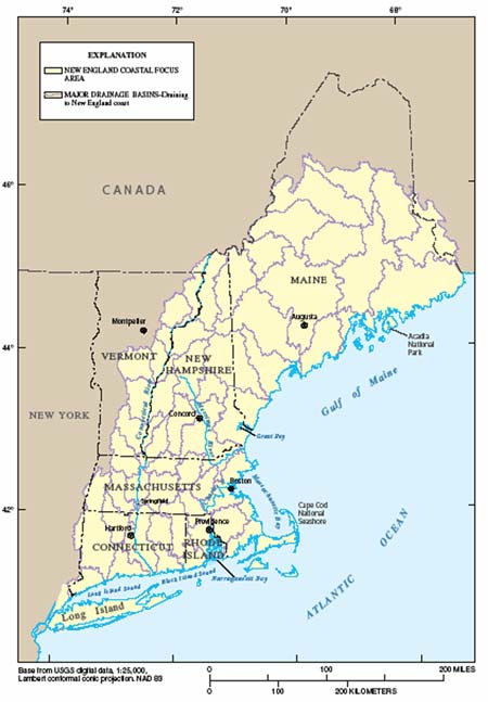
| Map showing Northeast coastal area |
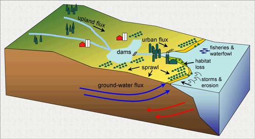 |
| Schematic diagram showing important natural processes and human pressures that
affect coastal ecosystems and resources of the Northeast. |
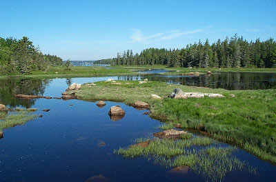 |
Wetlands habitat |
- Effects of streamflow depletion and water quality on habitat condition and ecosystem sustainability;
- Impact on coastal ecosystems of nutrient loading to coastal waters from surface- and ground-water, and atmospheric sources;
- Impact of invasive species on the structure, function, and sustainability of native plants and animals inhabiting coastal ecosystems; and,
- Effectiveness of restoration efforts in salt marshes, eutrophied embayments, commercial and recreational fisheries and shellfish beds, and disturbed eel grass habitats affected by urban sprawl.
 |
|
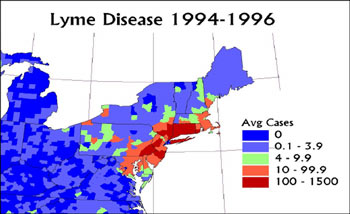
Graph showing incidence of Lyme disease, 1994-1996 |
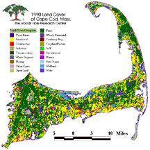 |
Map showing 1990 Cape Cod land cover |
The size, interstate location, and history of previous USGS work in the river make it a logical choice for integrated mountains-to-sea flux studies of water and sediment, integrated with ecological studies of anadromous fish and migratory birds. Natural resource management agencies, water-resource users and interested non-governmenal organizations seek scientific information to guide decisions about sustainable human uses that are compatible with maintaining functional ecosystems in a heavily populated area.
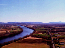 |
Connecticut River Valley |
| Crosswalk: Northeast Coastal Long-Term Integrated Science Priorities and Partners, Cooperators, and Stakeholders |
Department
of the Interior |
Federal Partners |
State
and Local |
Non- Governmental |
|||||||||||||||||
|
BLM |
FWS |
MMS |
NPS |
ACOE |
Census |
Coast |
EPA |
FEMA |
HUD |
NASA |
NIH- |
NIMA |
NOAA |
NRCS |
NSF- |
USFS |
State |
Universities |
Nature |
Audubon |
|
|
Fluxes: Water, Nutrients, |
|||||||||||||||||||||
|
Critical coastal wetland habitats |
X |
X |
X |
X |
X |
X |
X |
X |
X |
X |
|||||||||||
|
Remediation of toxic sediments |
X |
X |
X |
X |
X |
||||||||||||||||
|
Coastal aquifer interconnections with the sea |
X |
X |
X |
X |
X |
||||||||||||||||
|
Nutrient fluxes from wastewater |
X |
X |
X |
X |
|||||||||||||||||
|
River-seashore sediment interaction |
X |
X |
X |
X |
X |
X |
X |
||||||||||||||
|
Coastal Hazards |
|||||||||||||||||||||
|
Sea-level rise |
X |
X |
X |
X |
X |
X |
X |
||||||||||||||
|
Hazardous storms |
X |
X |
X |
X |
X |
X |
X |
X |
X |
X |
|||||||||||
|
Responses to climate variability and change |
X |
X |
X |
X |
X |
X |
X |
X |
|||||||||||||
|
Urbanization and Habitat Change |
|||||||||||||||||||||
|
Water resources |
X |
X |
X |
X |
X |
X |
X |
X |
|||||||||||||
|
Habitat health |
X |
X |
X |
X |
X |
X |
X |
X |
|||||||||||||
|
Human health |
X |
X |
X |
X |
X |
X |
X |
X |
X |
||||||||||||
|
Coastal contamination |
X |
X |
X |
X |
X |
X |
X |
X |
X |
||||||||||||
Biology |
Geography |
Geology |
Water |
||||||||||||||||||||||||||
| Crosswalk: Northeast Coastal Long-Term Integrated Science Priorities and Bureau Programs |
Biological |
Contaminants |
Cooperative |
Ecosystems |
Fisheries |
Invasive |
Status |
Wildlife |
Cooperative |
Land |
Geographic |
Coastal and |
Earth |
Earthquake |
Energy |
Geomagnetism |
Global |
Landslide |
Mineral |
National |
Volcano |
Federal-State |
Ground |
Hydrologic |
Hydrologic |
National |
National |
Toxic |
Water |
|
Fluxes: Water, Nutrients, |
|||||||||||||||||||||||||||||
|
Critical coastal wetland habitats |
X |
X |
X |
X |
X |
X |
X |
X |
X |
X |
X |
X |
X |
X |
|||||||||||||||
|
Remediation of toxic sediments |
X |
X |
X |
X |
X |
X |
X |
X |
X |
||||||||||||||||||||
|
Coastal aquifer interconnections with the sea |
X |
X |
X |
X |
X |
X |
X |
X |
|||||||||||||||||||||
|
Nutrient fluxes from wastewater |
X |
X |
X |
X |
X |
X |
X |
X |
X |
||||||||||||||||||||
|
River-seashore sediment interaction |
X |
X |
X |
X |
X |
X |
X |
X |
X |
||||||||||||||||||||
|
Coastal Hazards |
|||||||||||||||||||||||||||||
|
Sea-level rise |
X |
X |
X |
X |
X |
X |
X |
X |
X |
X |
X |
X |
X |
X |
X |
||||||||||||||
|
Hazardous storms |
X |
X |
X |
X |
X |
X |
X |
||||||||||||||||||||||
|
Responses to climate variability and change |
X |
X |
X |
X |
X |
X |
X |
X |
X |
X |
X |
||||||||||||||||||
|
Urbanization and Habitat Change |
|||||||||||||||||||||||||||||
|
Water resources |
X |
X |
X |
X |
X |
X |
X |
X |
X |
X |
X |
X |
X |
||||||||||||||||
|
Habitat health |
X |
X |
X |
X |
X |
X |
X |
X |
X |
X |
X |
X |
X |
X |
|||||||||||||||
|
Human health |
X |
X |
X |
X |
X |
X |
X |
X |
X |
X |
X |
X |
X |
X |
X |
X |
X |
X |
|||||||||||
|
Coastal contamination |
X |
X |
X |
X |
X |
X |
X |
X |
X |
X |
X |
||||||||||||||||||
USGS
Integrated Science Themes |
||||||
|
Crosswalk: Northeast Coastal Long-term
Integrated Science Priorities and Bureau Integrated Science Themes |
Water for humans and ecological needs |
Understanding large river systems |
Forecasting landscape change |
Status and trends across disciplines |
Applications of remote sensing and other monitoring |
Restoration of impaired habitats |
|
Fluxes: Water, Nutrients, |
||||||
|
Critical coastal wetland habitats |
X |
X |
X |
X |
X |
|
|
Remediation of toxic sediments |
X |
X |
X |
X |
||
|
Coastal aquifer interconnections with the sea |
X |
X |
||||
|
Nutrient fluxes from wastewater |
X |
X |
X |
|||
|
River-seashore sediment interaction |
X |
X |
X |
X |
X |
|
|
Coastal Hazards |
||||||
|
Sea-level rise |
X |
X |
X |
X |
||
|
Hazardous storms |
X |
X |
X |
|||
|
Responses to climate variability and change |
X |
X |
X |
X |
X |
X |
|
Urbanization and Habitat Change |
||||||
|
Water resources |
X |
X |
X |
X |
X |
|
|
Habitat health |
X |
X |
X |
X |
X |
|
|
Human health |
X |
X |
X |
X |
||
|
Coastal contamination |
X |
X |
X |
|||
I.
Urban Dynamic |
II. Ecosystem and Natural
Resources |
III. Human Health & Safety |
IV. Natural Hazards |
|||||||||||||
| Crosswalk: Northeast Coastal Long-Term Integrated Science Priorities and Eastern Region Integrated Science Priorities |
Water |
Habitat |
River and |
Urban expansion |
Climate |
Fish and |
Eutrophication |
Biodiversity, |
Invasive and |
Energy and |
Contaminants |
Pathogens |
Air |
Flooding, storms |
Earthquakes |
Slope failure |
|
Fluxes: Water, Nutrients, Sediment, |
||||||||||||||||
|
Critical coastal wetland habitats |
X |
X |
X |
X |
X |
X |
X |
X |
X |
X |
X |
X |
X |
|||
|
Remediation of toxic sediments |
X |
X |
X |
X |
X |
X |
X |
X |
X |
|||||||
|
Coastal aquifer interconnections with the sea |
X |
X |
X |
X |
X |
|||||||||||
|
Nutrient fluxes from wastewater |
X |
X |
X |
X |
X |
X |
X |
X |
X |
|||||||
|
River-seashore sediment interaction |
X |
X |
X |
X |
X |
X |
||||||||||
|
Coastal Hazards |
||||||||||||||||
|
Sea-level rise |
X |
X |
X |
X |
X |
X |
X |
X |
||||||||
|
Hazardous storms |
X |
X |
X |
X |
X |
X |
||||||||||
|
Responses to climate variability and change |
X |
X |
X |
X |
X |
X |
X |
X |
X |
X |
X |
|||||
|
Urbanization and Habitat Change |
||||||||||||||||
|
Water resources |
X |
X |
X |
X |
X |
X |
X |
X |
X |
X |
X |
|||||
|
Habitat health |
X |
X |
X |
X |
X |
X |
X |
X |
X |
X |
X |
X |
X |
|||
|
Human health |
X |
X |
X |
X |
X |
X |
X |
X |
X |
|||||||
|
Coastal contamination |
X |
X |
X |
X |
X |
X |
X |
X |
X |
X |
X |
|||||