Coastal Vulnerability Assessment of FIIS, USGS Open-File Report 03-439
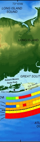
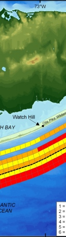
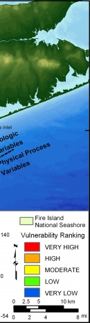
Figure 15. Relative Coastal Vulnerability for Fire Island National Seashore. The innermost color bar is the relative coastal vulnerability index (CVI). The remaining color bars are separated into the geologic variables (1-3) and physical process variables (4 - 6). The very high vulnerability shoreline is near Moriches inlet and the Fire Island lighthouse where the shoreline change rates are highest. High vulnerability shoreline is concentrated east of Watch Hill where overwash occurrence is most frequent. Moderate vulnerability shoreline is along the community section of Fire Island, and the low vulnerability portion of the shore lies within Robert Moses State Park where shoreline accretion rates are high because of spit progradation. Large-scale (10-15 km) coastal vulnerability is controlled by the geologic framework differences that exist east and west of Watch Hill. Smaller-scale (2-5 km) variations in vulnerability reflect the rates of historic shoreline change in the area. | |||||
|