THE ASSATEAGUE ISLAND NATIONAL SEASHORE (ASIS)
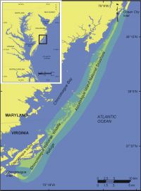 |
| Figure 1. Location of Assateague Island National Seashore in Maryland and Virginia. |
Assateague Island lies along the Atlantic coast of Maryland and Virginia (Figure 1). It is an undeveloped barrier island that consists of large stretches of dunes interrupted by low-lying areas that overwash during storms. Assateague Island is separated from Fenwick Island in Maryland by Ocean City Inlet, and is separated from Wallops Island and Chincoteague Island in Virginia by Chincoteague inlet.
The formation of Ocean City inlet during a hurricane in 1933 had a significant impact on the evolution of northern Assateague Island. Following the formation of Ocean City Inlet, the Army Corps of Engineers (USACE) built jetties to stabilize the inlet. Assateague Island began to experience accelerated rates of shoreline retreat as the jetties interrupted the longshore transport of sediment from north to south. In the 70 years since the opening of Ocean City Inlet, Assateague Island has retreated landward nearly 1 km. In an effort to mitigate this structure-induced shoreline change and habitat loss, NPS, the USACE, and the Minerals Management Service have implemented a restoration plan. The restoration plan will involve the placement of sand on Assateague beaches from an offshore borrow site.