USGS: Science for a Changing World - USGS visual identity mark and link to main Web site at http://www.usgs.gov/

U.S. Geological Survey Open-File Report 2004-1024

Mineral, Energy, and Fertilizer Resources of the North Coast of Perú: Perspective from the Santa Rita B Archaeological Site

By William E. Brooks,1 Jonathan D. Kent,2 and Jason C. Willett1

1U.S. Geological Survey, National Center, Reston, VA 20192 - wbrooks@usgs.gov
2Anthropology Department, Metropolitan State College, Denver, CO 80217

ABSTRACT

The Santa Rita B archaeological site is in the Chao Valley, approximately 65 km southeast of Trujillo, northern Perú. Location of Santa Rita B at the emergence of several drainages from the Andean cordillera is an important factor in the almost continuous occupation of the site over the past 3,000 years.

Mineral resources are abundant throughout the Andes; however, the north coast of Perú was an important center for pre-Columbian mining, metallurgy, and craftsmanship. Success of the Chavin, Moche, Chimu, and other north coast cultures is directly related to the availability and exploitation of mineral and energy resources that include: gold (±silver), as electrum, mainly from placers, and copper from local oxide and carbonate occurrences and from sulfides related to copper porphyry occurrences in the cordillera. An alloy of these three metals is referred to as tumbaga, which is the primary material for Andean metalcraft.

Anthracite was used for mirrors by north coast cultures and is available near Rio Chicama, Rio Santa, and east of Santa Rita B. These outcrops are a part of the Alto Chicama, Perú's largest coalfield, which extends from Rio Chicama, in the north, for 200 km southward to Rio Santa. Charcoal from the algorrobo tree and llama dung are considered to be the common pre-Columbian energy sources for cooking and metalwork; however, availability and the higher heat content of anthracite indicate that it was used in metallurgical applications. Bitumen is available from petroleum seeps near Talara, north of the study area, and may have been used as glue or as cement.

Hematite, goethite, limonite, and manganese oxides from clay-altered volcanic rock may have provided color and material for ceramics. Guano from the Islas Guañapes, Chinchas, and Ballestas was used as fertilizer for cotton and other crops.

INTRODUCTION

North coast of Peru from Rio Chicama south to Rio Santa

Figure 1. North coast of Perú from Rio Chicama south to Rio Santa. [SRB - Santa Rita B archaeological site. Base from parts of the Otuzco, Salaverry, Santa, Santiago de Chuco, and Santa Rosa 1:50,000 quadrangles. Cu, copper; Pb, lead; Ag, silver; C, coal. d, degrees; s, seconds]

[VIEW a better qualitity PDF file]


The purpose of this study is to locate the regional occurrences of mineral, energy, and fertilizer resources available to the north coast cultures of Perú from the perspective of the Santa Rita B Archaeological Site (SRB). Santa Rita B is approximately 65 km southeast of Trujillo and northeast of the town of Chao, Departamento La Libertad, northern Perú (fig. 1). The site is on a floodplain formed by the confluence of several local, northeast-to-southwest valleys that descend from the Andes and are collectively referred to as the Chao Valley. This valley, which is south of the Rio Moche Valley, is one of the more important of several valley systems in northern Perú explored by Lechtman (1976) because of its role in Andean metallurgy. Strategic location of Santa Rita B at the emergence of the Chao Valley from the cordillera is an important factor in the almost continuous occupation of the site over the past 3,000 years and may have provided control of the movement of resources, llamas, and people between the highlands and the coast. Ceramics from Santa Rita B include Moche III, Moche IV, Chimu, Chimu-Inca, and Inca styles.

MINERAL RESOURCES

Exploitation of Perú's abundant metals dates from 1410 to 1090 B.C. (Burger and Gordon, 1998; Cathro, 2000) to modern times (Petersen and others, 1990). However, the preeminence of north coast cultures in metallurgy and craftsmanship of copper, gold, and silver (Mujica, 1959) points to local availability and exploitation of resources and fuels for smelting. The intentional or accidental alloying of these metals, with occasional use of Hg (Kaufmann, 1978), resulted in tumbaga, an alloy that is commonly used in pre-Columbian Andean metalcraft. Platinum was also exploited and used in the Andean region but on a limited basis (Petersen, 1970; Craddock, 1995; Craig and others, 2001).

However, alloying of copper, gold, and silver as tumbaga for craft usage is not unique to pre-Columbian Andean cultures of South America, as is commonly thought. For example, in Japan, the black, copper-gold alloy used for jewelry and metalwork is termed "shakudo" and has 95 percent copper and 5 percent gold. An orange copper-silver alloy is referred to as "shibuichi" and has 75 to 85 percent copper and 15 to 25 percent silver (R.J. Farrell, oral communication, 2000). Japanese use of these metals in art dates to over 1,000 years ago when a gold, copper, and silver alloy, with occasional use of mercury, was used to decorate the protective ring or collar (habaki) between the blade of the ceremonial sword and the user's hand (Kapp and others, 1987).

Copper

Major copper deposits in Perú include Antamina, Cerro de Pasco, Morococha, Cerro Verde, Cuajone, Quellaveco, and Toquepala (Camus and others, 1996), and massive sulfides are being exploited north of Santa Rita B near Tambo Grande, Departamento Piura (Teggert and others, 2000).

SRB. -- There are seven major copper occurrences near Santa Rita B (Ministerio de Energia y Minas, 1999) and several copper and copper-lead-silver prospects east of Santa Rita B near Santiago de Chuco (Cossio and Pecho, 1964). Numerous copper prospects in the valleys near Chorobal and Santa Rita B were visited by Lechtman (1976). Our fieldwork resulted in finding a small copper mine less than 2 kilometers south of Santa Rita B on a low hill in Cerro Aguascalientes (fig. 1). Chrysocolla, abundant hematite and goethite from the breakdown of copper-sulfides, manganese oxide, and quartz veins (fig. 2) are present; copper values range from 416 parts per million (ppm) to 1.08 percent (table 1).

Chrysocolla and ceramic fragment from mine at Cerro Aguascalientes

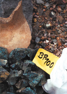
Figure 2. Chrysocolla and ceramic fragment from mine at Cerro Aguascalientes. Sample BP700 -- copper content (9000 ppm), table 1.
  Work area at copper mine at Cerro Aguascalientes

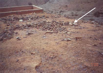
Figure 3. Angular stones outline work area at copper mine at Cerro Aguascalientes. White rocks to right are batanes (arrow), which are rounded stream cobbles used for crushing. Evidence of recent activity is shown by brick wall. Adits are immediately below these structures.


The Cerro Aguascalientes prospect has a small leach pad, brick buildings, and other signs of recent activity; therefore, any evidence for pre-Columbian mining at this site has been compromised. However, directly above the adits are found abundant ceramic fragments, charcoal, and stone outlines of three connected 4x6-m work areas (fig. 3). Within these stone outlines are several batanes (rounded river stones that are 20 to 30 cm in diameter) that were possibly used for crushing. Juxtaposition of the mine, abundant ceramic fragments, location on a hilltop for wind to fire smelting hearths or to dissipate smelting fumes, and the stone structures are strong evidence that the site was initially a pre-Columbian mine with an associated workshop. Adits in the mine are sinuous and were likely opened by firesetting, a common ancient mining technique (Craddock, 1995).

Table 1.  Analytical data for samples collected in conjunction with study of the Santa Rita B archaeological site, north coast Perú
[Fire-assay and atomic absorption methods by Cone Geochemical, Lakewood, CO, values in ppm, parts per million, unless otherwise noted]


Sample
no.
Au Cu Pb Zn Ag As Hg Sb   Comments

Chan Chan


BP100
0.003 20 4 69 0.2 5 0.01 1  

Tschudi "scoria"

Quartz veins


BP200
0.002 5 6 34 0.2 1 0.16 1  

Cm sized quartz vein, low hills east of SRB


BP300
0.001 48 11 73 0.2 2 0.12 1  

Cm sized quartz vein, low hills east of SRB


BP1000
0.001 38 19 51 0.2 3 0.01 1  

Sheared volcanic rock, base of Cerro Cabra


BP1100
0.002 118 2 710 0.2 7 0.01 1  

Cm quartz vein along shear, Cerro Cabra


BP1200
0.011 119 7 42 0.2 310 0.01 3  

Vertical quartz vein, Km 503, Pan Am Highway


BP1300
0.004 51 54 126 0.6 9 0.02 1  

Vertical quartz vein, Km 503, Pan Am Highway


BP1400
0.004 404 15 242 0.4 41 0.01 4  

Vertical quartz vein, Km 503, Pan Am Highway


BP2100
0.001 52 1 14 0.2 1 0.01 2  

Quartz vein, near Cerro La Cruz

Mina Cerro Aguascalientes


BP500
0.509 1460 67 700 5.7 310 0.47 179  

Area sample from adit


BP600
0.420 416 22 123 3.9 44 0.35 148  

Quartz vein in iron stained volcanic rock


BP700
0.010 9000 13 2500 0.2 2 0.09 2  

Chrysocolla float


BP800
0.754 3150 140 2430 6.5 93 0.67 13  

Area sample with oxide stain


BP2200
0.070 1.08% 6 4130 0.4 6 0.03 3  

Spot sample in adit

Colonial smelter -- near Chorobal


BP1500
0.001 87 1 78 0.2 3 0.01 5  

"Scoria"


BP1600
0.046 26 2 13 0.2 114 0.03 6  

Calcite for flux


BP1700
0.002 14 1 15 0.2 1 0.04 5  

Quartz for flux

Cerro Durango


BP1900
0.023 5790 146 203 4.1 99 0.02 40  

Polymetallic vein


BP2000
0.120 3.04% 10 105 18.0 12 0.17 8  

Polymetallic vein

Clay pit -- road to Chorobal


BP1800
0.015 333 27 216 0.5 22 0.05 3  

Altered volcanic rock, clay quarry

Baños de Chimu -- Alto Chicama


BP3000
0.020 66 42 295 0.9 1060 0.23 55  

Altered clastic rock near hot spring


Copper content of 3.0 percent with elevated lead and silver content was found during reconnaissance of Cerro Durango, northeast of Santa Rita B. However, owing to the absence of lead artifacts in the archaeological record, it is unlikely that polymetallic veins were exploited or were used as primary sources of copper or silver.

Gold

Perú hosts 14 major gold-producing districts (Ministerio de Energia y Minas, 1999) and at least 75 gold mines (Noble and Vidal, 1994). Three of these districts -- Cajamarca, Pataz, and Salpo -- are close to Santa Rita B. Of these three, Pataz has been a major gold-producing region since pre-Columbian times (Schreiber and others, 1990) and, through trade, was the source of gold for Chimu craftsmen (Mujica, 1959). Gold is commonly found in placer deposits in rivers, quartz veins, disseminated as micron-sized flakes, and in volcanic rocks associated with calderas. Placer gold was the likely source of most pre-Columbian gold because it was the easiest to mine and required little or no preparation before crafting. Goldworking is more commonly associated with centers north of the Moche Valley than it is with the Chao area (Bawden, 1999).

SRB. -- Several sites with the structural preparation for gold, such as iron-oxide-stained quartz veins (fig. 4) and shear zones with quartz veins, were found near Santa Rita B. These sites were sampled in order to evaluate the possibility of quartz-vein gold near the site. However, gold content of these veins was low, from < 0.001 to 0.01 ppm (table 1). The highest gold content for samples analyzed during this study was 0.5 to 0.7 ppm (fig. 5) at the Cerro Aguascalientes copper occurrence. Smelting of the Aguascalientes ore may have yielded a primary copper-gold alloy with little need for admixed gold. Fieldwork indicates that potential for quartz vein gold near Santa Rita B is low.

Detail of vertical iron oxide stained quartz vein north of Chao

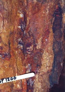
Figure 4. Detail of N55°E/vertical, iron oxide stained quartz vein north of Chao, near Km 503 marker on the Pan American Highway. Sample BP1200 -- gold content (0.01 ppm), table 1.
  Quartz vein with iron oxide stain at Cerro Aguascalientes mine

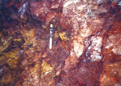
Figure 5. Quartz vein with iron oxide stain at Cerro Aguascalientes mine. Sample BP500 -- gold content (0.5 ppm), table 1.


Silver

Silver occurrences are numerous throughout the Andes (Ministerio de Energia y Minas, 1999). The closest active silver mine is at Quiruvilca (translation, silver tooth in Quechua) studied by Bartos (1990) and now operated by Pan American Silver Perú. Several copper-lead-silver prospects are located east of Santa Rita B near Santiago de Chuco (Cossio and Pecho, 1964), and silver may also occur naturally with gold as electrum.

SRB. -- The highest silver content found during this study was 18 ppm (fig. 6) in samples collected from polymetallic veins near the Cerro Durango drainage northeast of Santa Rita B. However, there is no evidence to indicate that polymetallic veins or argentiferous galena were exploited. Several Spanish colonial sites with evidence for smelting and processing of ore were described by Lechtman (1976) along Rio Huaraday northeast of Santa Rita B. Scoria, quartz, and calcite used for flux were sampled from one of these colonial smelters near Chorobal (fig. 7) (table 1).

Polymetallic vein near Cerro Durango

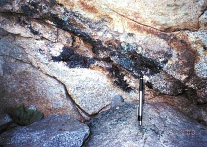
Figure 6. Polymetallic vein near Cerro Durango. Sample BP2000 -- silver content (18 ppm) and copper content (3.0 percent), table 1.
  Spanish colonial smelter near town of Chorobal

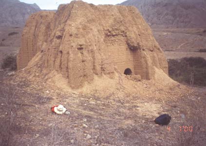
Figure 7. Spanish colonial smelter near town of Chorobal, Chao Valley.


Other Resources

Other mineral occurrences available near Santa Rita B include hematite, limonite, and manganese oxides derived from altered volcanic rock. These may have provided pigment (for example, ochre; Farnsworth, 1951) and clay for ceramics. There is no evidence for mercury near Santa Rita B; however, both mercury for metallurgy and cinnabar for decoration of mummies and masks (Mujica, 1959) were available through trade from mining areas in the cordillera near Huancavelica. Malachite and chrysocolla, available locally and also known as cardenillo, have artistic applications (Farnsworth, 1951) and were commonly used in Moche craft (Mujica, 1959). Salt, which also has metallurgical applications (Bray, 1985; Ramage and others, 2000), was also available along the north coast from shallow lagoons (Peele, 1893).

ENERGY RESOURCES

Charcoal from the algorrobo tree, dung, and plant material are considered to be the common pre-Columbian energy fuels (Lechtman, 1976; Shimada and Merkel, 1991). However, the combined effects of the depletion of algorrobo forests and the regional availability and higher heat content of anthracite (for example, 12,000-13,000 Btu/lb and 2 percent sulfur, as received, for Baños de Chimu coal; Escudero, 1979) permit the consideration of coal as a fuel in ancient metallurgical processes. Tylecote (1980) used the major oxide chemistry of ash at archaeological sites to determine whether the original fuel was coal, llama dung, or wood. Application of ash chemistry to ash horizons preserved at Chan Chan, a major Chimu center near Trujillo (fig. 1), has helped determine that coal was burned at Ciudadela Tschudi (Brooks and Willett, 2002), a part of the Chan Chan complex archaeological complex.

There are references to the use of coal by ancient Peruvians. Anthracite, sometimes referred to as jet, was used for mirrors (Hyams and Ordish, 1963; Burger 1992; Morris and von Hagen, 1993; Larco, 2001) and jewelry. Oscar Lostaunau, a Peruvian archaeologist (Lechtman, 1976), found bits of coal associated with an ancient north coast smelting site.

Considerations for the use of coal as a fuel by ancient Peruvians are compelling and include:

Coal

Coal is present throughout Perú (Ministerio de Energia y Minas, 1999) and data on Peruvian coalfields, reserves, and usage was compiled by Burgess (1985) and Weaver (1993). Estimates of the number of coal occurrences in Perú varies by author. For example, Weaver and Wood (1994) list 89; Carrascal and others (2000) provide information on 230 occurrences; and Instituto Geológico Minero y Metalúrgico (undated) lists 51. Peruvian coal ranges in rank from lignite to anthracite; however, the most significant occurrences are anthracite coal deposits that are Cretaceous in age (Alvarado, 1980; Agramonte and Diaz, 1983; Dunin-Borkowski, 1996). Escudero (1979) outlined an extensive area in northern Perú, the Alto Chicama, that extends from Rio Chicama (translation, coal in Quechua) in the north to Rio Santa in the south (fig. 1). This extensive area is also referred to as the Northern Anthracite Field by Petersen (1983). The Alto Chicama is considered to be the most significant coal resource area in Perú in terms of quality (7-23 percent ash, 7,000-13,000 Btu/lb, and less than 1 percent sulfur, as received) and quantity (223,710,000 metric tons) (Escudero, 1979; Carrascal and others, 2000).

SRB. -- North of Santa Rita B, anthracite is now being mined at Baños de Chimu (fig. 8), where miners report that pots and plates with pre-Inca animal designs were found in the mine. The name of this area is taken from a nearby hot spring that has altered the host sandstones as indicated by the presence of elevated arsenic (1,060 ppm), mercury (0.23 ppm), and other elements (table 1). Arsenic and mercury are considered elevated in comparison with the average crustal arsenic content of 1 ppm and average crustal mercury content of 0.03 ppm for sandstones established by Turekian and Wedepohl (1961).

Coal mine at Banos de Chimu

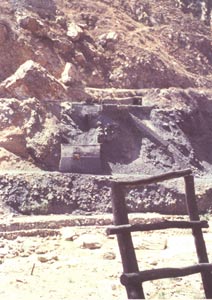
Figure 8. Coal mine at Baños de Chimu, Alto Chicama.
  Domestic use of coal from Banos de Chimu

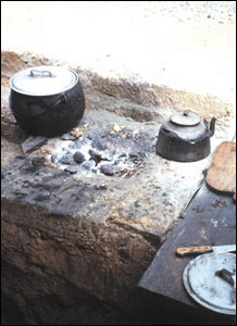
Figure 9. Domestic use of coal from Baños de Chimu, Alto Chicama.
  Coal briquette burner used to heat water in the town of Chao

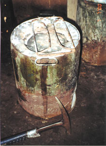
Figure 10. Coal briquette burner used to heat water in the town of Chao.


Today, coal mined from Mina La Victoria, near Quiruvilca (fig. 1), is burned directly for domestic use (fig. 9) or processed into briquettes for use in small unvented burners (fig. 10). Similarly, coal mined from this area may have been used by ancient people. Mining has also taken place at Mina Callacuyan, near Quiruvilca, but due to the high sulfur content of the coal (as much as 14-23 percent; Carrascal and others, 2000), mining has ceased. There are numerous mines and prospects in Cretaceous rocks 40 km east of the study area, near a village named Ancos. Of the mines in this area, Mina Galgada is one of the more well known (Cossio and Pecho, 1964; Dunin-Borkowski, 1996). Coal is also mined from the Santa Basin near Rio Santa, south of the study area (fig. 1). Because of the transport of coal float from the mouth of the Rio Santa, this coal is occasionally washed up as "sea coal" on the beach near Huanchaco, north of Trujillo, and may have provided a limited resource to ancient Peruvians (fig. 11).

Coal float found on the beach at Huanchaco     
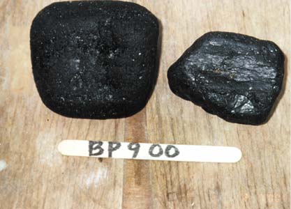
Figure 11. Coal float found on the beach at Huanchaco, north of the city of Trujillo. Possibly transported by longshore currents from coal occurrences in the Rio Santa drainage, southeast of the city of Trujillo.


Proximate and ultimate data and trace element geochemical data on coal samples from mines at Baños de Chimu and from La Victoria (fig. 1) are provided by Brooks and Willett (this volume).

Bitumen

Along the north coast of Perú near Talara, bitumen was used by the Spaniards to caulk their ships (Barrett, 1999). Bitumen has also been used to attach arrowheads, as a cement for stonework at Cuzco (Hyams and Ordish, 1963), for goldworking (Bray, 1985), or as a glue (for example, to secure shells as decoration onto a ceremonial timber known as the Poste Sagrado on display at the Museum of Anthropology, Archaeology, and History in Lima). However, thusfar, no reference to the use of this resource as a fuel by north coast cultures has been found.

In North America, by comparison, approximately 1000 years ago the Karankawa tribe of the Gulf Coast of Texas used bitumen from seeps as a paint on their ceramics and as a glue to attach points to wooden shafts (Ricklis, 1996; Newcomb, 1999). Modern groups in the Amazon region of Perú also use bitumen as a glue in the construction of blowguns. Bitumen may have been used in the treatment of some mummies in Persia (Arriaza, 1995); however, widespread use of bitumen in the mummification process is disputed by R. Evershed and S. Buckley of the University of Bristol (Glausiuz, 2002). Bitumen-lined coffins have been documented in Syria.

FERTILIZER RESOURCES

The Moche, who were the prevalent group in northern Perú approximately 2000 years ago, were probably the first to exploit the rich guano deposits derived from sea birds on the nearby Islas Guañapes (fig. 1), a resource initially described by Raimondi (1878). In a display at the Smithsonian Museum of Natural History it is indicated that these deposits were at least 20 m deep; Moche artifacts have been found in the guano. Ancient reed boats or "caballitos" similar to those in figure 12 and also shown in Moche drawings (Bawden, 1999) were used to reach the islands and transport the guano back to the coast for agricultural use. This natural resource, rich in nitrogen (13 percent), phosphate (12.5 percent), and potassium (2.5 percent) (Craig and others, 2001), was also used by the Inca at Machu Picchu and was exported to Europe during the 19th century (Rubio, 1988). Guano, which had almost been depleted, has now been replaced by artificial fertilizers in the Chao Valley. However, this ancient resource now presents new economic opportunities for exploitation (Elton, 2001). Along the south coast of Perú, guano deposits are also present on the Islas Chinchas (Bawden, 1999) and Ballestas. Phosphate-rich sands composed mainly of fish bones, scales, and teeth are occasionally exploited near Bayóvar in northern Perú (Caldas and others, 1980), but whether or not ancient man exploited this fertilizer resource for agriculture is unknown.

Caballitos, or reed fishing boats in use at Huanchaco beach

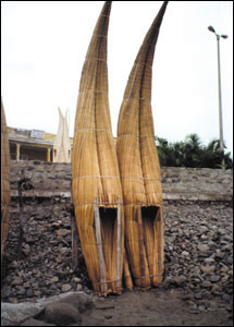
Figure 12. Caballitos, or reed fishing boats, in use at Huanchaco beach, north of the city of Trujillo.
  Copper tweezers from Santa Rita B

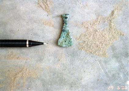
Figure 13. Copper tweezers from Santa Rita B.


OTHER MATERIALS

Charcoal, llama dung, potsherds, animal and human bones, seeds, and land and marine shells have been recovered from Santa Rita B. Additionally, ceramic, shell, and metal beads have also been found and catalogued. Copper artifacts include items such as pins, flat sheets, wire, tweezers (fig. 13), and a small tumi or knife (fig. 14). A stone cylinder (fig. 15) made from medium-grained porphyritic andesite was located on the slopes of Cerro Santa Rita, just west of the site. Shape, composition, and dimensions of this cylinder suggest comparison to an ancient metalworker's stone anvil and hammers (Grossman, 1972; Bird, 1979), which were used to make foils.

Copper knife or tumi from Santa Rita B

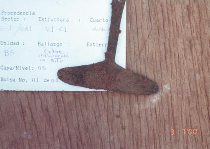
Figure 14. Copper knife or tumi from Santa Rita B.
   Andesite cylinder that may have been used as an anvil for making metal foils, found near Santa Rita B

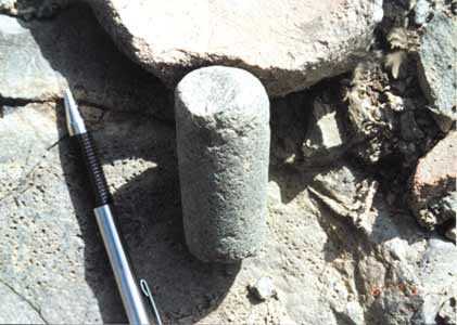
Figure 15. Andesite cylinder that may have been used as an anvil for making metal foils, found near Santa Rita B.


CONCLUSIONS

Santa Rita B is well situated to have exploited the abundant mineral, energy, and fertilizer resources identified in the north coast, especially the copper occurrences identified in the Chao Valley. Additionally, Santa Rita B occupied a key position for commerce in metallic resources from the cordillera and fertilizer and other maritime resources from the coast. The regional occurrence of energy fuels, such as anthracite, near Santa Rita B indicates the availability of an abundant, accessible, alternative fuel source, in addition to charcoal and animal dung, that may have been used domestically or in metallurgy.

SELECTED BIBLIOGRAPHY

Alvarado, B., 1980, Recursos de carbon en Suramerica: Revue de L'Institut Francais du Petrole, v. 35, no. 2, p. 387-421.

Agramonte, J., and Diaz, A., 1983, Inventario preliminar del carbon mineral en el Perú: Instituto Geológico Minero y Metalúrgico Boletin 6, 98 p.

Arriaza, B.T., 1995, Beyond death -- The Chinchorro mummies of ancient Chile: Washington, D.C., Smithsonian Institution Press, 176 p.

Bargellini, F., 1992, El uso del carbon en la industria del cobre: Minerales, v. 47, no. 197, p. 64-74.

Barrett, P., 1999, Perú -- Insight Guide: Singapore, APA Publications, 356 p.

Bartos, P.J., 1990, Metal ratios of the Quiruvilca mining district, northern Perú: Economic Geology, v. 55, p. 1629-1644.

Bawden, G., 1999, The Moche: Massachusetts, Blackwell Publishers, 375 p.

Bird, J.B., 1979, The copper man -- A prehistoric miner and his tools from northern Chile, in Benson, E.P., ed., Pre-columbian Metallurgy of South America: Washington, D.C., Dumbarton Oaks Research Library and Collections, p. 105-132.

Bray, W., 1985, Ancient American metallurgy, in Jones, J., ed., The Art of Precolumbian Gold, The Jan Mitchell Collection: Boston, Little, Brown and Company, p. 76-84.

Brooks, W.E., and Willett, J.C., 2002, Coal usage indicated at Chan Chan, northern Perú: Geological Society of America Abstracts with Programs, Annual Meeting, v. 34, no. 6, p. 184.

Burger, R.L., 1992, Chavin and the origins of Andean civilization: New York, Thames and Hudson, 248 p.

Burger, R.L., and Gordon, R.B., 1998, Early central Andean metalworking from Mina Perdida, Perú: Science, v. 282, p. 1108-1111.

Burgess, I.C., 1985, Peruvian coal studies: Nottingham, British Geological Survey-Technical Report, Overseas Geology Series, no. 85/1, 25 p.

Caldas, J., Palacios, O., Pecho, V., and Vela, C., 1980, Geologia de los cuadrangulos de Bayovar, Sechura y Morrope: Instituto Geológico Minero y Metalúrgico Boletin 32, 78 p.

Camus, F., Sillitoe, R.M., and Petersen, R., 1996, Andean copper deposits: Society of Economic Geologists Special Publication 5, 198 p.

Carrascal, R., Matos, C., and Silva, O., 2000, Carbón en El Perú: Instituto Geológico Minero y Metalúrgico Boletin no. 7, serie B, Geología Económica, Lima, Perú, 150 p.

Cathro, R.J., 2000, The history of mining and metallurgy in Latin America, 1500 BC-1600 AD, in Sherlock, R., and Logan, A., (eds.), Volcanogenic Massive Sulfide Deposits of Latin America, Geological Association of Canada, Mineral Deposits Division, Special Publication 2, p. 1-17.

Cossio, A., and Pecho, V., 1964, Mapa geologico del cuadrangulo de Santiago de Chuco: Instituto Geológico Minero y Metalúrgico Mapa 17-g, scale 1:100,000.

Craddock, P.T., 1995, Early metal mining and production: Washington, D.C., Smithsonian Institution Press, 363 p.

Craig, J.R., Vaughan, D.J., and Skinner, B.J., 2001, Resources of the Earth: New Jersey, Prentice Hall, 520 p.

Dunin-Borkowski, E., 1996, Minerales industriales del Perú: Instituto Geológico Minero Y Metalúrgico, Publicacion Especial, 166 p.

Elton, C., 2001, Vaivenes de una industria milenaria: Americas, April, p. 6-15.

Escudero, J., 1979, El carbon del Alto Chicama: Instituto Geológico Minero y Metalúrgico Boletin 2, Lima, 79 p.

Farnsworth, M., 1951, Ancient pigments: Journal of Chemical Education, v. 28, p. 72-76.

Glausiusz, J., 2002, Recipe for the dead; Discover, v. 23, no. 3, p. 20-21.

Grossman, J.W., 1972, An ancient gold worker's tool kit: Archaeology, v. 25, no. 4, p. 270-275.

Hyams, E., and Ordish, G., 1963, The last of the Incas: New York, Barnes and Noble, 294 p.

Instituto Geológico Minero y Metalúrgico, undated, Yacimientos no metalicos del Perú: Lima, 13 p.

Kapp, L., Kapp, H., and Yoshira, Y., 1987, The craft of the Japanese sword: Tokyo, Kodansha International, 167 p.

Kauffman, F., 1978, Manual de arqueología Peruana: Lima, 800 p.

Larco, R., 2001, Los Mochicas: Lima, Museo Arqueologico Rafael Larco Herrera, 350 p.

Lechtman, H., 1976, A metallurgical site survey in the Peruvian Andes: Journal of Field Archaeology, v. 3, no 1, p. 1-42.

Ministerio de Energía y Minas, 1999, Atlas -- Mineria y energía en el Perú: Lima, 111 p.

Morris, C., and von Hagen, A., 1993, The Inka empire and its Andean origins: New York, Abbeville Press, 251 p.

Mujica, M., 1959, Gold museum of Perú: Recklinghausen, Germany, Aurel Bongers, 305 p.

Newcomb, W.W., 1999, The Indians of Texas (12th ed.): Austin, University of Texas Press, 404 p.

Noble, D.C., and Vidal, C.E., 1994, Gold in Perú: Society of Economic Geologists Newsletter, no. 17, p. 1-13.

Peele, R., 1893, A Peruvian salt mine: (Columbia College) School of Mines Quarterly, v. 15, p. 219-221.

Pfordte, O.F., 1893, Ancient method of silver-lead smelting in Perú: Transactions of the American Institute of Mining Engineers, v. 21, p. 25-30.

Petersen, C.R., 1983, Coal resources of Perú, in Kottlowski, F.E., Cress, A.T., and Meyerhoff, A.A., eds., Coal Resources of the Americas, Selected Papers: Boulder, Colorado, Geological Society of America: The Geology of North America Special Paper 179, p. 35-42.

Petersen, G., 1970, Mineria y metalurgia en el antiguo Perú: Arqueologicas 12, Publicaciones del Instituto de Investigaciones Antropologicas, Museo Nacional de Antropologia y Arqueologia, Lima, Perú, 140 p.

Petersen, U., Vidal, C.E., and Noble, D.C., 1990, A special issue devoted to the mineral deposits of Perú preface: Bulletin of the Society of Economic Geologists, v. 85, no. 7, p 1287-1295.

Raimondi, A., 1878, Minerales del Perú: Lima, Imprenta del Estado, 305 p.

Ramage, A., Craddock, P., Craddock, P.T., 2000, King Croesus' gold -- Excavations at Sardis and the history of gold refining, v. 11: Boston, Mass., Harvard University Press, 264 p.

Ricklis, R.A., 1996, The Karankawa Indians of Texas: Austin, University of Texas Press, 222 p.

Rubio, P., 1988, Perú: Madrid, Biblioteca Iberoamericana, 127 p.

Schreiber, D.A., Fontbote, L., and Lochmann, D., 1990, Geologic setting, paragenesis, and physicochemistry of gold quartz veins hosted by plutonic rocks in the Pataz region: Economic Geology, v. 85, p. 1328-1347.

Shimada, I., and Merkel, J.F., 1991, Copper-alloy metallurgy in ancient Perú: Scientific American, v. 265, no. 1, p. 80-86.

Teggert, P., Allen, G., and Carstensen, A., 2000, Regional setting, stratigraphy, alteration and mineralization of the Tambo Grande VMS district, Piura Department, northern Perú, in Sherlock, R., and Logan, A., eds., Volcanogenic massive sulfide deposits of Latin America: Geological Association of Canada, Mineral Deposits Division, Special Publication 2, p. 1-17.

Turekian, K.K., and Wedepohl, K.H., 1961, Distribution of the elements in some major units of the Earth's crust: Geological Society of America Bulletin, v. 72, p. 175-191.

Tylecote, R.F., 1980, Furnaces, crucibles, and slags, in Wertime, T.A., and Muhly, J.D., eds., The coming of the Age of Iron: New Haven, Conn., Yale University Press, p. 183-228.

Weaver, J.N., 1993, Coal in Latin America: U.S. Geological Survey Open File Report 93-239, 60 p.

Weaver, J.N., and Wood, G.H., 1994, Coal map of South America: U.S. Geological Survey Map C-145, scale 1:7,500,000


U.S. Department of the Interior, U.S. Geological Survey
URL: http://pubsdata.usgs.gov/pubs/of/2004/1024/1024.html
For more information, contact William E. Brooks
Maintained by Eastern Publications Group
Last modified: 22:57:51 Sat 12 Jan 2013
Privacy statement | General disclaimer | Accessibility