U.S. Geological Survey Open-File Report 2004-1030 (Published May 2004)
The Upper Floridan aquifer is part of the Floridan aquifer system that underlies most of the Coastal Plain of Georgia, southern South Carolina, extreme southeastern Alabama, and all of Florida (Miller, 1986). The aquifer system is one of the most productive in the United States and a major source of water in the coastal area of Georgia. In 1997, approximately 347 million gallons per day (Mgal/d) of ground water was withdrawn in coastal Georgia mainly for industrial and irrigation purposes (Fanning, 1999).
This report shows the potentiometric surface of the Upper Floridan aquifer in coastal Georgia for September 2000. The potentiometric surface, which represents the altitude at which water would have stood in tightly cased wells open to the Upper Floridan aquifer, was constructed by using water-level and pressure measurements collected from 225 wells during September 2000. The distribution of data used to construct the map is similar to a previously contoured map (Peck and others, 1999) with the exception of the Jesup, Wayne County area. In this area, a cone of depression has historically been present due to industrial pumping of about 63.9 Mgal/d (Fanning, 2003). During September 2000 however, water-level measurements were not obtained in this area; therefore, the May 1998 surface (Peck and others, 1999) is shown on an inset map.
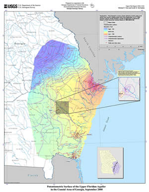
Potentiometric surface of the Upper Floridan aquifer
in the coastal area of Georgia, September 2000
(1.3 MB PDF file, print size 34 in. x 44 in.)
This study was conducted as part of the Georgia Department of Natural Resources, Environmental Protection Division's Sound Science Initiative, a series of scientific and feasibility studies designed to determine how to limit or reduce saltwater intrusion in coastal Georgia. As part of this program, the U.S. Geological Survey (USGS), in cooperation with the Environmental Protection Division (EPD), Georgia Geologic Survey (GGS), is investigating the paths and rates of saltwater movement into the Upper Floridan aquifer, determining other areas where saltwater contamination could occur, assessing alternative sources of freshwater supplies, such as the surficial and upper and lower Brunswick aquifers, and developing a monitoring network to assess ground-water levels and quality.
Two vector digital geospatial datasets are provided as zipped archive ESRI©[1] shapefiles[1] or as a zipped archive ArcInfo© coverage workspace format of original point measurements of well locations and the manually interpreted contour lines from these points. Additionally, a raster-based water-surface elevation model is provided in an ArcInfo© GRID format, or as a formatted data file, which was derived from the two vector data sources using the TOPOGRID function of ArcInfo. The completed map is available in an Adobe Acrobat Portable Document Format (PDF) file .
Downloads:
References Cited
Fanning, J.L., 1999, Water use in coastal Georgia by county and source, 1997; and water-use trends, 1980-97: Georgia Geologic Survey Information Circular 104, 37 p.
Fanning, J.L., 2003, Water use in Georgia by county for 2000 and water-use trends for 1980-2000: Georgia Geologic Survey Information Circular 106, 176 p.
Miller, J.A., 1986, Hydrogeologic framework of the Floridan aquifer system in Florida and parts of Georgia, Alabama, and South Carolina: U.S. Geological Survey Professional Paper 1403-B, 91 p.
Peck, M.F., Clarke, J.S., Ransom, Camille III, and Richards, C.J., 1999, Potentiometric surface of the Upper Floridan aquifer in Georgia and adjacent parts of Alabama, Florida, and South Carolina, May 1998, and water level-trends in Georgia, 1990-98: Georgia Geologic Survey Hydrologic Atlas 22, 1 sheet.
[1] Use of trade names does not constitute endorsement by the U.S. Government.
This report is complete online: the above text, and the map in pdf format:
Open-File Report 2004-1030 (1.3 MB)
To view the map, you need the Adobe Acrobat® Reader installed on
your computer. (A free
copy of the Acrobat® Reader may be downloaded from Adobe Systems
Incorporated.)
Document Accessibility: Adobe Systems Incorporated has information about PDFs and the visually impaired. This information provides tools to help make PDF files accessible. These tools and the accessible reader may be obtained free from Adobe at Adobe Access.
Recent USGS publications on Georgia or Georgia Water-Resources Information
For more information, please contact webmaster-ga@usgs.gov.
| AccessibilityFOIAPrivacyPolicies and Notices | |
 |
|