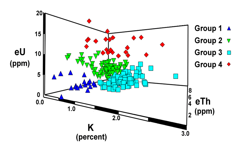
All of the in situ gamma-ray data collected at sites on the Palos Verdes Peninsula were classified into groups using a maximum likelihood clustering algorithm. These calculations were done to test how well the gamma-ray data discriminate the different geologic units. The data were clustered into four groups based upon the potassium (K), uranium (eU), and thorium (eTh) concentrations. The figure below shows a 3-dimensional representation of the groups and the table lists the mean values and standard deviations for each of the groups. Groups 1 and 3 generally correspond to areas of terrace cover or the lower part of the Altamira Shale. Group 2 may reflect the Valmonte Diatomite although a number of sites classified as group 2 lie within areas mapped as the phosphatic lithofacies of Conrad and Ehlig (1987). Group 4 is probably characteristic of the more uraniferous parts of the phosphatic lithofacies.
|
Group |
Potassium |
Uranium |
Thorium |
|||
|
Number |
% K |
Std. Dev. |
ppm eU |
Std. Dev. |
ppm eTh |
Std. Dev. |
|
1 |
0.5 |
0.2 |
2.3 |
1.5 |
1.7 |
0.8 |
|
2 |
0.9 |
0.3 |
6.2 |
1.7 |
3.6 |
1.0 |
|
3 |
1.4 |
0.3 |
2.7 |
1.4 |
4.2 |
0.9 |
|
4 |
1.2 |
0.5 |
13.0 |
2.5 |
3.7 |
1.0 |
[an error occurred while processing this directive]