The description of the geology presented here is based mainly upon that of Conrad and Ehlig (1987). The Palos Verdes Peninsula is part of an extensive, mostly submarine terrane where Middle Miocene and younger sediments lie unconformably on a tectonically disrupted basement of Mesozoic Catalina Schist (Platt, 1975; Howell and Vedder, 1981). The uplift and unroofing of the Catalina Schist are estimated to have occurred about 16 mybp in the Middle Miocene (Woodford, 1925; Stuart, 1979) and the marine sediments of the Monterey Formation were deposited from the Middle Miocene to the Upper Miocene (based on fossils found by Woodring, Bramlette, and Kew, 1946). Subsequent volcanic activity resulted in sills and irregularly-shaped intrusions of basalt, minor pillow basalt, and extensive tuff. The Monterey Formation is overlain by Pliocene Repetto Siltstone along the northern edge of the peninsula. Uplift starting in the Pliocene resulted in the submarine formation of a doubly plunging anticline along the south side of the northwest-trending Palos Verdes fault. The anticline emerged as an island during the Early Pleistocene and became part of the mainland by the end of the Pleistocene.
Click on the geologic unit identifiers for brief descriptions of the units.
Woodring, Bramlette, and Kew (1946) subdivided the Monterey Formation of the Palos Verdes Peninsula into three members: Altimira Shale, Valmonte Diatomite, and Malaga Mudstone. The Altimira Shale is the oldest and the Malaga Mudstone is the youngest. They further subdivided the Altimira Shale into lower, middle and upper parts using the top of Portuguese Tuff as the top of the lower part and a change from cherty shale to phosphatic shale as the boundary between the middle and upper parts. Because of difficulties in distinguishing the subdivisions of the Altimira Shale in the field, they did not attempt to map the sub-units. Click here to view a digital rendition of the geology as mapped by Woodring, Bramlette, and Kew (1946).
The Altamira Shale is the oldest of three subunits of the Monterey Shale and underlies most of the area of the Palos Verdes peninsula. Conrad and Ehlig (1987) found that they could not map the boundary between the lower and middle parts of the Altamira Shale using the Portuguese Tuff because it is either not present or not recognizable in many areas. Instead, they divided the Altamira Shale into tuffaceous, cherty, and phosphatic lithofacies. The tuffaceous lithofacies extends to the highest occurrence of basalt and thick tuff beds and includes all of the lower and most of the middle parts of the Altamira Shale as defined by Woodring, Bramlette, and Kew (1946). The cherty lithofacies is equivalent to the upper 16 m of the middle part of the Altamira Shale as defined by Woodring, Bramlette, and Kew (1946) and the phosphatic lithofacies is the same as their upper part of the Altamira Shale. According to Conrad and Ehlig (1987) the change from the cherty to the phosphatic lithofacies was likely caused by a regional change in oceanographic and climatic change rather than a local change in climate. Click here to view a digital version of the map published by Conrad and Ehlig (1987).
Conrad and Ehlig (1987) estimate that tuff and tuffaceous sedimentary rocks comprise 10 to 20 percent of the total volume of the tuffaceous lithofacies. They found that silty shale dominates in the lower part of the type section (along the Crenshaw extension) whereas porcelanite dominates in the upper part. Sandy shale, tuff, tuffaceous siltstone, dolostone, and dolomitic siltstone are also common in the type section (Conrad and Ehlig, 1987). Six samples from the tuffaceous lithofacies were analyzed and found to contain less than 3 ppm uranium (table 4, Conrad and Ehlig, 1987).
The type section of the cherty lithofacies (along the Crenshaw extension) consists of 16 m of porcelanite and chert with minor dolostone and siliceous shale (Conrad and Ehlig, 1987). According to Conrad and Ehlig (1987), the most distinctive lithology within the cherty lithofacies is a zone of ellipsoidal chert concretions that is present near the center of the lithofacies throughout the peninsula and serves as a valuable marker horizon.
The type section of the phosphatic lithofacies at the Crenshaw extension contains 25 m of soft phosphatic and diatomaceous siltstone and shale (Conrad and Ehlig, 1987). Conrad and Ehlig (1987) note that fine-grained sandstone occurs in beds from a few millimeters thick to a few centimeters thick. These beds are interlayered with diatomaceous shale throughout the section but are most abundant in the upper two-thirds of the section. Two samples from the section were analyzed and found to contain greater than 25 ppm uranium (table 4, Conrad and Ehlig, 1987).
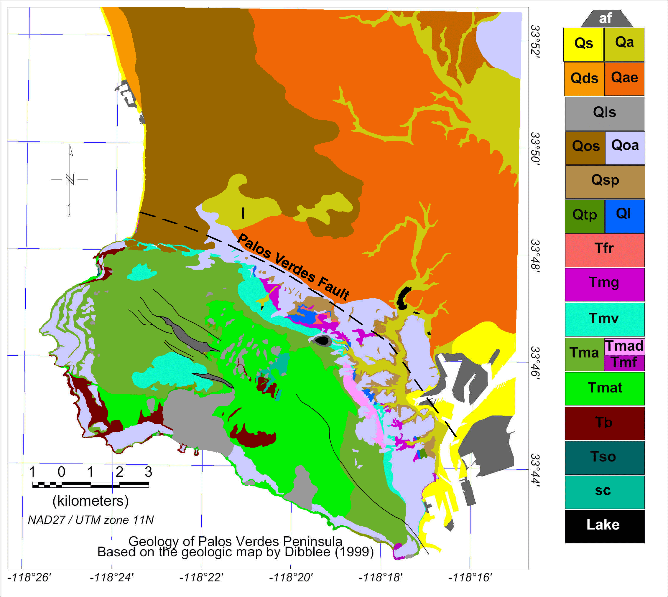
In 1999, Dibblee (1999) published a geologic map (click here to see a digital version of that map) at a scale of 1:24,000 that incorporates most of the information from the maps of Woodring, Bramlette, and Kew (1946) and Conrad and Ehlig (1987).
The Valmonte Diatomite overlies the Altamira Shale and includes the relatively pure diatomaceous strata of the Monterey as defined by Woodring, Bramlette, and Kew (1946). They note that diatomite occurs in the Valmonte in layers or laminae of varying thickness. In some areas they found thinly laminated diatomite several feet thick alternating with massive diatomaceous mudstone but in other areas the exposed Valmonte consists of laminated diatomite and diatomaceous shale.
The Malaga Mudstone, the youngest of the three Monterey Formation members, overlies the Valmonte Diatomite and is defined as the uppermost member of the Monterey shale according to Woodring, Bramlette, and Kew (1946). The Malaga Mudstone consists mostly of massive radiolarian mudstone or fine-grained siltstone with layers of diatomite and diatomaceous shale and limestone concretions and lenses (Woodring, Bramlette, and Kew, 1946). The Malaga is only found along the northern and eastern margins of the Palos Verdes hills.
As the Palos Verdes Peninsula rose above sea level, marine terraces formed around what was then an island. Woodring, Bramlette, and Kew (1946) identified a series of terraces of different ages at elevations ranging from near sea level up to 1,200 feet above sea level. They numbered the mapped terraces from 1 (youngest) to 13 (oldest). The oldest terraces occur in the vicinity of San Pedro Hill. Click here to view a digital version of the terrace map.
Most of the marine terraces are covered by non-marine deposits of sand, pebbles, and cobbles. Deposits covering the younger terraces were shown as terrace cover on the geologic map by Woodring, Bramlette, and Kew (1946) and as older alluvium on the map by Dibblee (1999).
[an error occurred while processing this directive]