The Cape Hatteras National Seashore
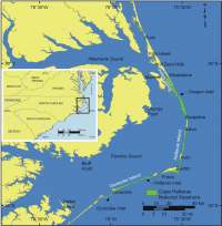 |
| Figure 1. Location of Cape Hatteras National Seashore in North Carolina. Click on figure for larger image. |
Cape Hatteras National Seashore is part of the Outer Banks of North Carolina, which stretch more than 280 kilometers (175 miles) from Virginia to Shackleford Banks, along the Atlantic coast of North Carolina (Figure 1). The National Seashore extends 115 km (70 mi) over portions of three barriers islands, Bodie, Hatteras, and Ocracoke. These narrow barriers are separated from the North Carolina mainland by wide, shallow Pamlico Sound. Most of the barriers within the National Seashore are only a few hundred (<400 m) meters in width and they lie entirely within the 100-year flood zone (Wolverton and Wolverton, 1988). The widest part of Cape Hatteras National Seashore is near Cape Point between Buxton and Frisco; here the barrier reaches a maximum width of about 4 km.
Nor'easters, hurricanes, and tropical storms all pass over the Outer Banks allowing storms to potentially play a role in coastal evolution throughout the year. The combination of intense storms and shallow shoals near Cape Hatteras has led to this area being named the Graveyard of the Atlantic. Historians estimate that over 1000 shipwrecks have occurred along the North Carolina coast since the 1600s (for more information see http://coastalguide.com/packet/
shipwrecks01.htm or http://www.nps.gov/caha/
shipwreck.htm).
Storm impacts on coastal evolution along the Outer Banks are too numerous to detail here, but for a comprehensive overview of storms and storm tracks along the coast of North Carolina since 1933 see: http://www.erh.noaa.gov/er/akq/hist.htm. Also a summary of the recent impacts of Hurricane Isabel (September 2003) is hosted by USGS at: http://coastal.er.usgs.gov/hurricanes/Isabel/.
Six locations in and around the national seashore have been identified by the Outer Banks Task Force (http://www.obtf.org/) as erosional hot spots, or sections of coast where the dunes are frequently destroyed by storms. Sections of North Carolina highway 12 have been relocated in these hot spot areas, and when breaks form in the dunes they are immediately filled, which may interfere with natural barrier overwash processes. Some scientists suggest that storms and overwash processes are essential to the evolution of these barriers, and human interference through dune building, road maintenance, and breach filling only ensures an increase in vulnerability of these islands (Dolan and Lins, 1986; Pilkey and others, 1998). Park managers, charged with resource preservation for future generations, are faced with a difficult task along the Outer Banks.
This report does not directly address the vulnerability of the bay side shoreline of Cape Hatteras National Seashore to future sea-level rise, because the methodology presented here does not apply well to quieter water or estuarine wetland environments; however, the authors acknowledge the important issues impacting the Pamlico and Albemarle Sound shoreline and direct interested readers to investigations on sea-level rise and estuarine shoreline erosion along the North Carolina Coast produced by Riggs (2001) and Riggs and Ames (2003).