Skip past header information USGS Logo with link to USGS web page
Coastal Vulnerability Assessment of Cape Hatteras National Seashore to Sea-Level Rise, USGS Open-File Report 2004-1064


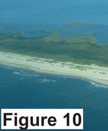
Figure 10. Numerous overwashes have occurred on the eastern end of Ocracoke Island. Deposits from washover events are visible on the landward side of the island (very high vulnerability).


Figure 10. Numerous overwashes have occurred on the eastern end of Ocracoke Island.  Figure 10.  Numerous overwashes have occurred on the eastern end of Ocracoke Island.  Figure 10.  Numerous overwashes have occurred on the eastern end of Ocracoke Island.

Skip Footer Information [an error occurred while processing this directive]