 |
|
|
||||
| Open-File Report 2004-1085: Online Report |
| About USGS / Science Topics / Maps, Products & Publications / Education / FAQ |
This report is preliminary and has not been reviewed for conformity with the U.S. Geological Survey editorial standards or with the North American Stratigraphic Code.
Any use of trade names is for descriptive purposes only and does not imply endorsement
by the U.S. Government.
U.S. DEPARTMENT OF THE INTERIOR
U.S. GEOLOGICAL SURVEY
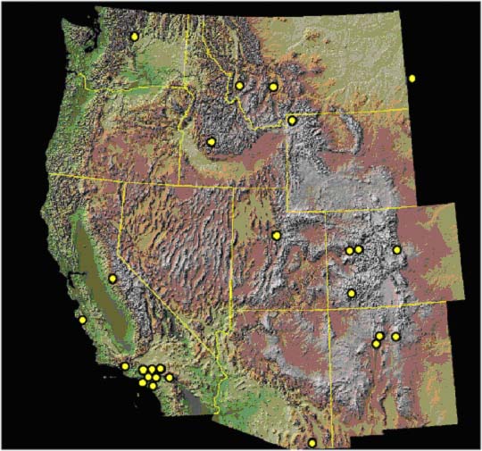
This report supersedes Open-file Report 01-0474 and is a compilation of peak-discharge and volume data measured from basins burned by wildfire in the western U.S. Changes that have been made include the addition of three recent wildfire related debris-flow events in Colorado and Utah, three historic events in southern California, more complete rainfall information, and some minor restructuring of the table. Each point in Figure 1 represents the location of a fire that resulted in a significant debris-flow or sediment-laden flood event. These points are linked to a database organized by state that includes the location and year of the fire, measures of basin area and relief ratio, the percentage of the basin burned, discharge and/or volume of deposits, rainfall conditions, the runoff process and a reference for each event. The information compiled here is a combination of published and personally communicated data. When not reported by the original reference, we measured basin areas and relief ratios from 1:24,000 scale topographic maps or from DEMs using GIS. The relief ratio is expressed as a percentage and is calculated by dividing the change in elevation of the longest stream channel extended to the drainage divide by the length of that channel. In some cases we measured basin areas using the DEM. The references for this report can be linked to by clicking on the reference or author’s name. The Database and References can also be accessed directly through these links. This database will be periodically updated as a new Open-File Report as more information becomes available. If you have data you would like to contribute to this database contact Sue Cannon at cannon@usgs.gov.
| AccessibilityFOIAPrivacyPolicies and Notices | |
| |
|