THE CUMBERLAND ISLAND NATIONAL SEASHORE
The barrier islands of South Carolina, Georgia, and northernmost Florida are wide and short when compared to many other East Coast barriers for two reasons. First, the mean tidal range is greater than 1 meter along the Georgia Bight, which creates a large tidal prism in the backbarrier; therefore inlet spacing is closer in order to accommodate the volume of water exchanged during a tidal cycle (Hayes, 1979). Second, two generations of barrier islands have welded together to make up the present-day Georgia barriers. The core of the barrier islands was formed during the late Pleistocene when sea level was approximately a meter higher than present (Oertel, 1979). The Holocene (modern) portion of the barriers in southern Georgia is thin and generally comprises only the foredunes and shoreface. Along the central portion of Cumberland Island, parts of the Pleistocene barrier are exposed at the shoreface.
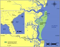 |
| Figure 1. Location of Cumberland Island National Seashore in North Carolina. Click on figure for larger image. |
Cumberland Island and Little Cumberland Island stretch about 30 km (~ 19 miles) from St. Andrews Sound to the Florida border (Figure 1). Christmas Creek separates Little Cumberland Island from 'big' Cumberland Island to the south. Little Cumberland Island lies within National Park Service legislative boundaries, but it remains privately owned and is not subject to park jurisdiction. Cumberland Island National Seashore has a rich archeological history that began about 4,000 years ago with Native American inhabitants, followed by European explorers, British occupation during the War of 1812, and Civil War fortification. Other major historical influences on the archeology and also the present character of Cumberland Island include the Plantation Era and the Carnegie Estate (for more information on the history of Cumberland Island see: http://koransky.com/Trip/History/CumberlandIslandGA/History.html). In 1972, the park service began acquiring land through purchases and donations. Since the establishment of Cumberland Island National Seashore, the Park Service has tried to preserve the important cultural and natural resources on Cumberland Island. Threats to resource preservation include feral pigs and horses, regional development, and erosion of the backbarrier shore.