Skip past header information USGS Logo with link to USGS Web page
Coastal Vulnerability Assessment of Cumberland Island National Seashore to
Sea-Level Rise, USGS Open-File Report 2004-1196

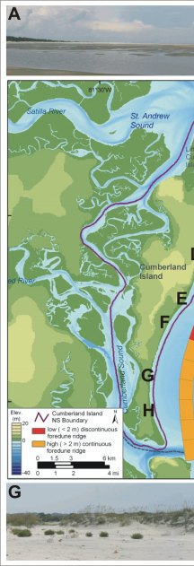
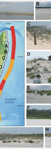
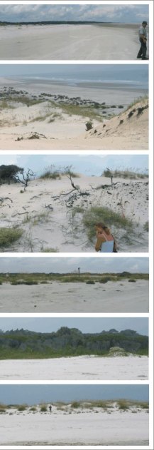
Figure 3. The colorbar indicates geomorphology along the ocean shore of Cumberland Island National Seashore. Geomorphology within the red area consists of low discontinuous foredunes (< 2m), while the orange area consists of high or more continuous foredunes (> 2m). A) Photo taken from Long Point looking towards Christmas Creek. The dunes are low and generally coppice mounds near Long Point. B) Low elevation dunes located south of Christmas Creek. C) A location where the height of the foredune ridge changes. The photo is taken looking north from a high dune (> 5m). D) A high elevation foredune ridge that is actively migrating into maritime forest. E) and F) These are low elevation overwash areas where the foredune ridge is low or absent. G) and H) Although the dunes are lower here than at location C and D, they are more stable and continuous. H) The person is 1.8 m tall for scale.

Figure 3. The colorbar indicates geomorphology along the ocean hore of Cumberland Island National Seashore. Figure 3. The colorbar indicates geomorphology along the ocean hore of Cumberland Island National Seashore. Figure 3. The colorbar indicates geomorphology along the ocean hore of Cumberland Island National Seashore.

Skip Footer Information [an error occurred while processing this directive]
Figure 3A. Photo from Long Point looking towards Christmas Creek, dunes are low and generally coppice near Long Point. Figure 3G. Although the dunes are lower here than at location C and D they are more stable and continuous. Figure 3A. Photo from Long Point looking towards Christmas Creek, dunes are low and generally coppice near Long Point. Figure 3B. Low elevation dunes south of Christmas Creek. Figure 3C. Location where the height of the foredune ridge changes, the photo is taken looking north from a high dune (> 5m). Figure 3D. High elevation foredune ridge, the dunes in this area are migrating into maritime forest. Figure 3E. Low elevation overwash areas where the foredune ridge is low or absent. Figure 3F. Low elevation overwash areas where the foredune ridge is low or absent. Figure 3G. Although the dunes are lower here than at location C and D they are more stable and continuous. Figure 3H. Although the dunes are lower here than at location C and D they are more stable and continuous. Figure 3B. Low elevation dunes south of Christmas Creek. Figure 3C. Location where the height of the foredune ridge changes, the photo is taken looking north from a high dune (> 5m). Figure 3D. High elevation foredune ridge, the dunes in this area are migrating into maritime forest. Figure 3E. Low elevation overwash areas where the foredune ridge is low or absent. Figure 3F. Low elevation overwash areas where the foredune ridge is low or absent. Figure 3H. Although the dunes are lower here than at location C and D they are more stable and continuous.