Skip past header information USGS Logo with link to USGS Web page
Coastal Vulnerability Assessment of Cumberland Island National Seashore to
Sea-Level Rise, USGS Open-File Report 2004-1196


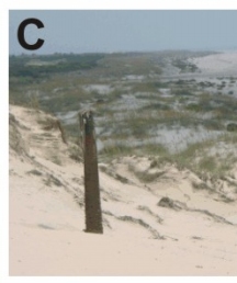
Figure 3C. A location where the height of the foredune ridge changes. The photo is taken looking north from a high dune > 5m).


Figure 3C. Location where the height of the foredune ridge changes. Figure 3C. Location where the height of the foredune ridge changes. Figure 3C. Location where the height of the foredune ridge changes.

Skip Footer Information [an error occurred while processing this directive]