

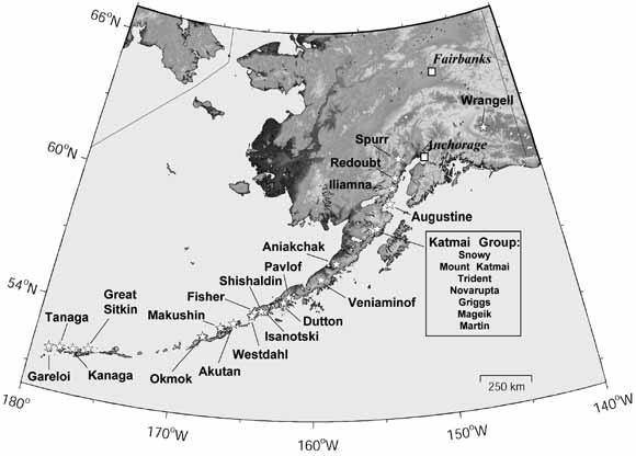
Alaskan volcanoes seismically instrumented by AVO in 2003. Stars show the location of volcanoes and squares show the location of Anchorage and Fairbanks. |
|
The Alaska Volcano Observatory (AVO), a cooperative program of the U.S. Geological Survey, the Geophysical Institute of the University of Alaska Fairbanks, and the Alaska Division of Geological and Geophysical Surveys, has maintained seismic monitoring networks at historically active volcanoes in Alaska since 1988. The primary objectives of this program are the near real time seismic monitoring of active, potentially hazardous, Alaskan volcanoes and the investigation of seismic processes associated with active volcanism. This catalog presents the calculated earthquake hypocenter and phase arrival data, and changes in the seismic monitoring program for the period January 1 through December 31, 2003. The AVO seismograph network was used to monitor the seismic activity at twenty-seven volcanoes within Alaska in 2003. These include Mount Wrangell, Mount Spurr, Redoubt Volcano, Iliamna Volcano, Augustine Volcano, Katmai volcanic cluster (Snowy Mountain, Mount Griggs, Mount Katmai, Novarupta, Trident Volcano, Mount Mageik, Mount Martin), Aniakchak Crater, Mount Veniaminof, Pavlof Volcano, Mount Dutton, Isanotski Peaks, Shishaldin Volcano, Fisher Caldera, Westdahl Peak, Akutan Peak, Makushin Volcano, Okmok Caldera, Great Sitkin Volcano, Kanaga Volcano, Tanaga Volcano, and Mount Gareloi. Monitoring highlights in 2003 include: continuing elevated seismicity at Mount Veniaminof in January-April (volcanic unrest began in August 2002), volcanogenic seismic swarms at Shishaldin Volcano throughout the year, and low-level tremor at Okmok Caldera throughout the year. Instrumentation and data acquisition highlights in 2003 were the installation of subnetworks on Tanaga and Gareloi Islands, the installation of broadband installations on Akutan Volcano and Okmok Caldera, and the establishment of telemetry for the Okmok Caldera subnetwork. AVO located 3911 earthquakes in 2003. This catalog includes: (1) a description of instruments deployed in the field and their locations; (2) a description of earthquake detection, recording, analysis, and data archival systems; (3) a description of velocity models used for earthquake locations; (4) a summary of earthquakes located in 2003; and (5) an accompanying UNIX tar-file with a summary of earthquake origin times, hypocenters, magnitudes, phase arrival times, and location quality statistics; daily station usage statistics; and all HYPOELLIPSE files used to determine the earthquake locations in 2003. |
Download the text portion of this report as a PDF document (of2004-1234.pdf; 12.3 MB)
Download the data to accompany this report as an archived and compressed file (2003AVOEarthquakeCatalog.tar.Z; 8.7 MB)
A .tar file is a tape archive file. A .tar file keeps related files together, and thus facilitates the transfer of multiple files between computers. The files in a .tar archive must be extracted before they can be used.
A .tar.Z file is a .tar file that has subsequently been compressed. These files must be both uncompressed and then untarred before they can be used.
For questions about the content of this report, contact James Dixon
| Help
| PDF help
| Publications main page | Open-File
Reports for 2004 |