
U.S. Geological Survey
Open File Report 04-1302
On-line only
Version 1.0
By Curt Larsen1, Inga Clark1, Glenn Guntenspergen2, Don Cahoon2,
Vincent Caruso1, Cliff Hupp1, and Tom Yanosky1
1USGS, Reston, VA, 2USGS, Patuxent Wildlife Research Center, Laurel, MD
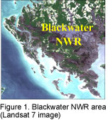 The Blackwater National Wildlife Refuge (BNWR), on the Eastern Shore of Chesapeake Bay (figure 1), occupies an area less than
1 meter above sea level. The Refuge has been featured prominently in studies of the impact of sea level rise on coastal
wetlands. Most notably, the refuge has been sited by the Intergovernmental Panel on Climate Change (IPCC) as a key
example of "wetland loss" attributable to rising sea level due to global temperature increase. Comparative studies
of aerial photos taken since 1938 show an expanding area of open water in the central area of the refuge. The
expanding area of open water can be shown to parallel the record of sea level rise over the past 60 years.
The Blackwater National Wildlife Refuge (BNWR), on the Eastern Shore of Chesapeake Bay (figure 1), occupies an area less than
1 meter above sea level. The Refuge has been featured prominently in studies of the impact of sea level rise on coastal
wetlands. Most notably, the refuge has been sited by the Intergovernmental Panel on Climate Change (IPCC) as a key
example of "wetland loss" attributable to rising sea level due to global temperature increase. Comparative studies
of aerial photos taken since 1938 show an expanding area of open water in the central area of the refuge. The
expanding area of open water can be shown to parallel the record of sea level rise over the past 60 years.
The U.S. Fish and Wildlife Service (FWS) manages the refuge to support migratory waterfowl and to preserve endangered upland species. High marsh vegetation is critical to FWS waterfowl management strategies. A broad area once occupied by high marsh has decreased with rising sea level. The FWS needs a planning tool to help predict current and future areas of high marsh available for waterfowl.
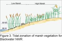
"Wetland loss" is a relative term. It is dependant on the boundaries chosen for measurement. Wetland vegetation, zoned by elevation and salinity (figure 3), respond to rising sea level. Wetlands migrate inland and upslope and may vary in areas depending on the adjacent land slopes. Refuge managers need a geospatial tool that allows them to predict future areas that will be converted to high and intertidal marsh. Shifts in location and area of coverage must be anticipated. Viability of a current marsh area is also important. When will sea level rise make short-term management strategies to maintain an area impractical?
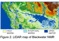 The USGS has developed an inundation model for the BNWR centered on the refuge and surrounding areas. Such models
are simple in concept, but they require a detailed topographic map upon which to superimpose future sea level positions.
The new system of LIDAR mapping of land and shallow water surfaces has solved this problem. Our team has developed
a detailed LIDAR map of the BNWR area at a 30 centimeter (ca. 1 ft) contour interval (figure 2). The new map allows us to
identify the present marsh vegetation zones and to predict the location and area of future zones on a decade-by-
decade basis over the next century at increments of sea level rise on the order of 3 cm/decade (ca. 1 inch).
The USGS has developed an inundation model for the BNWR centered on the refuge and surrounding areas. Such models
are simple in concept, but they require a detailed topographic map upon which to superimpose future sea level positions.
The new system of LIDAR mapping of land and shallow water surfaces has solved this problem. Our team has developed
a detailed LIDAR map of the BNWR area at a 30 centimeter (ca. 1 ft) contour interval (figure 2). The new map allows us to
identify the present marsh vegetation zones and to predict the location and area of future zones on a decade-by-
decade basis over the next century at increments of sea level rise on the order of 3 cm/decade (ca. 1 inch).
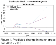
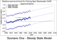
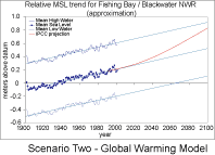
We have developed two scenarios for the model. The first is a steady-state model that uses the historic rate of sea level rise of 3.1 mm/yr to predict marsh areas. The second is a "global warming" scenario utilizing a conservative IPCC model with an exponentially-increasing rate of sea level rise. Under either scenario, the BNWR is progressively inundated with an expanding core of open water. Although their positions change in the future, the areas of intertidal marsh as well as those of the critical high marsh remain fairly constant until the year 2050. Beyond that time, the low-lying land surface is overtopped by rising sea level and the area is dominated by open water.
Our model suggests that wetland habitat in the Blackwater area might be maintained and sustained through a combination of public and private preservation efforts through easements in combination with judicious Federal land acquisition into the predicted areas of suitable marsh formation - but for only the next 50 years. Beyond that time much of this area will become open water.
 |
 |
 |
 |
For additional information please contact Curt Larsen or Inga Clark.
[an error occurred while processing this directive]