USGS Logo with link to USGS home page.

USGS Open File Report 2004-1400

pr_eez_region - United States Exclusive Economic Zone Regional Boundary.

pr_eez_region - United States Exclusive Economic Zone Regional Boundary

Metadata also available as - [Questions & Answers] - [Parseable text] - [XML]

Metadata:


Identification_Information:
Citation:
Citation_Information:
Originator: National Oceanic and Atmospheric Administration (NOAA)
Publication_Date: 20031203
Title:
pr_eez_region - United States Exclusive Economic Zone Regional Boundary
Edition: 1.0
Geospatial_Data_Presentation_Form: vector digital data
Other_Citation_Details:
Originally entitled: Approved Exclusive Economic Zone for Puerto Rico and the U.S. Virgin Islands, USA.
Online_Linkage: <http://nauticalcharts.noaa.gov/csdl/mbound.htm>
Online_Linkage:
<http://pubs.usgs.gov/of/2004/1400/data/boundaries/pr_eez_region.zip>
Larger_Work_Citation:
Citation_Information:
Originator: Uri ten Brink
Originator: William Danforth
Originator: Chris Polloni
Originator: Castle Eugene Parker
Originator: Toshi Uozumi
Originator: Glynn Williams
Publication_Date: 2004
Title:
Project PROBE Leg II - Final Report and Archive of Swath Bathymetric Sonar, CTD/XBT and GPS Navigation Data Collected During USGS Cruise 03008 (NOAA Cruise RB0303) Puerto Rico Trench 18 February - 7 March, 2003
Geospatial_Data_Presentation_Form: vector digital data
Series_Information:
Series_Name: Open-File Report
Issue_Identification: 2004-1400
Publication_Information:
Publication_Place: Woods Hole, MA
Publisher: U.S. Geological Survey, Coastal and Marine Geology Program
Other_Citation_Details:
Puerto Rico Trench Project Probes Legs I and III: 24 September - 30 September, 2002; and 28 August - 4 September, 2003, respectively relative to Leg II.
Online_Linkage: <http://pubs.usgs.gov/of/2004/1400>
Description:
Abstract:
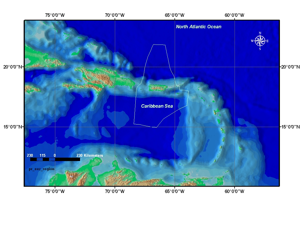
Exclusive Economic Zone (EEZ) and Maritime Boundaries; Notice of Limits By Presidential Proclamation No. 5030 made on March 10, 1983, the United States established an exclusive economic zone, the outer limit of which is a line drawn in such a manner that each point on it is 200 nautical miles from the baseline from which the breadth of the territorial sea is measured. The Government of the United States of America has been, is, and will be, engaged in consultations and negotiations with governments of neighboring countries concerning the delimitation of areas subject to the respective jurisdiction of the United States and of these countries. The limits of the exclusive economic zone of the United States as set forth below are intended to be without prejudice to any negotiations with these countries or to any positions which may have been or may be adopted respecting the limits of maritime jurisdiction in such areas. Further, the limits of the exclusive economic zone set forth below are without prejudice to the outer limit of the continental shelf of the United States where that shelf extends beyond 200 nautical miles from the baseline in accordance with international law.
Purpose:
The purpose of this data layer is to provide a general basemap showing the United States EEZ for the Puerto Rico area as studied by the U.S. Geological Survey, Coastal Marine Geology Program and National Oceanic Atmospheric Administration (NOAA).
Time_Period_of_Content:
Time_Period_Information:
Single_Date/Time:
Calendar_Date: 2004
Currentness_Reference: publication date
Status:
Progress: Complete
Maintenance_and_Update_Frequency: None planned
Spatial_Domain:
Bounding_Coordinates:
West_Bounding_Coordinate: -68.482224
East_Bounding_Coordinate: -63.888889
North_Bounding_Coordinate: 21.856779
South_Bounding_Coordinate: 14.930000
Keywords:
Theme:
Theme_Keyword_Thesaurus: General
Theme_Keyword: U.S. Geological Survey
Theme_Keyword: USGS
Theme_Keyword: Exclusive Economic Zone
Theme_Keyword: EEZ
Theme_Keyword: boundary
Theme_Keyword: GIS
Theme_Keyword: Geographic Information System
Theme_Keyword: regional boundary
Place:
Place_Keyword_Thesaurus: General
Place_Keyword: North America
Place_Keyword: North Atlantic Ocean
Place_Keyword: Puerto Rico
Place_Keyword: US Possessions
Place_Keyword: US Caribbean Islands
Place_Keyword: Atlantic Ocean
Place_Keyword: Caribbean Sea
Access_Constraints: None
Use_Constraints: These data are not to be used for legal purposes.
Point_of_Contact:
Contact_Information:
Contact_Organization_Primary:
Contact_Organization: U.S. Geological Survey
Contact_Person: Glynn Williams
Contact_Position: Spatial Data Technician
Contact_Address:
Address_Type: mailing and physical address
Address: 384 Woods Hole Road
City: Woods Hole Road
State_or_Province: Massachusetts
Postal_Code: 02543-1598
Country: USA
Contact_Voice_Telephone: 508.548.8700x2290
Contact_Facsimile_Telephone: 508.457.2310
Contact_Electronic_Mail_Address: gwilliams@usgs.gov
Hours_of_Service: 8:00AM to 5:00PM; M-F
Data_Set_Credit:
Public domain data from the U.S. government are freely redistributable with proper metadata and source attribution. Please recognize the U.S.Geological Survey and National Oceanic Atmospheric Administration as the source of this information.
Native_Data_Set_Environment:
Microsoft Windows 2000 Version 5.1 (Build 2600) Service Pack 2; ESRI ArcCatalog 8.3.0.800

Data_Quality_Information:
Attribute_Accuracy:
Logical_Consistency_Report:
No additional checks for topological consistency were performed on this data set.
Completeness_Report: complete
Positional_Accuracy:
Horizontal_Positional_Accuracy:
Vertical_Positional_Accuracy:
Lineage:
Source_Information:
Source_Citation:
Citation_Information:
Originator: National Oceanic Atmospheric Administration (NOAA)
Publication_Date: 19980401
Title: Exclusive Economic Zone and Maritime Boundaries
Geospatial_Data_Presentation_Form: vector digital data
Online_Linkage: <http://nauticalcharts.noaa.gov/csdl/eez.htm>
Source_Time_Period_of_Content:
Time_Period_Information:
Single_Date/Time:
Calendar_Date: 19980401
Source_Currentness_Reference: publication date
Source_Contribution:
The original EEZ coverage was downloaded from the NOAA website and was used as the base data layer for separating the Puerto Rico EEZ region (see NOAA Special Projects Office or <http://nauticalcharts.noaa.gov/csdl/eez.htm>)
Process_Step:
Process_Description: Created ArcView shapefile from coverage.
Source_Used_Citation_Abbreviation: pr_eez_region.zip
Process_Date: 20010630
Source_Produced_Citation_Abbreviation: pr_eez_region.dbf
Source_Produced_Citation_Abbreviation: pr_eez_region.shx
Source_Produced_Citation_Abbreviation: pr_eez_region.sbx
Source_Produced_Citation_Abbreviation: pr_eez_region.shp
Process_Contact:
Contact_Information:
Contact_Organization_Primary:
Contact_Organization: U. S. Geological Survey
Contact_Person: Chris Polloni
Contact_Position: Information Specialist
Contact_Address:
Address_Type: mailing and physical address
Address: 384 Woods Hole Road
City: Woods Hole
State_or_Province: Massachusetts
Postal_Code: 02543-1598
Country: USA
Contact_Voice_Telephone: 508-548-8700 x2280
Contact_Facsimile_Telephone: (508)457-2310
Contact_Electronic_Mail_Address: cpolloni@usgs.gov
Hours_of_Service: 8:00AM to 5:00PM; M - F
Process_Step:
Process_Description: EEZ boundary for Puerto Rico extracted for this project.
Source_Used_Citation_Abbreviation: pr_eez_region.zip
Source_Used_Citation_Abbreviation: useez.shp
Source_Used_Citation_Abbreviation: useez.shx
Process_Date: 20040730
Source_Produced_Citation_Abbreviation: pr_eez_region.dbf
Source_Produced_Citation_Abbreviation: pr_eez_region.shp
Source_Produced_Citation_Abbreviation: pr_eez_region.shx
Source_Produced_Citation_Abbreviation: pr_eez_region.sbx
Process_Contact:
Contact_Information:
Contact_Organization_Primary:
Contact_Organization: U.S. Geological Survey
Contact_Person: Chris Polloni
Contact_Position: Information Specialist
Contact_Address:
Address_Type: mailing and physical address
Address: 384 Woods Hole Road
City: Woods Hole
State_or_Province: Massachusetts
Postal_Code: 02543-2310
Country: USA
Contact_Voice_Telephone: 508-548-8700x2280
Contact_Facsimile_Telephone: 508.457.2310
Contact_Electronic_Mail_Address: cpolloni@usgs.gov
Hours_of_Service: 8:00AM to 5:00PM; M-F
Process_Step:
Process_Description:
Using ArcGIS Arctools the Horizontal Datum was changed from NAD 1983 to WGS 1984 (See special reference information)
Source_Used_Citation_Abbreviation: pr_eez_region.zip
Source_Produced_Citation_Abbreviation: pr_eez_region.dbf
Source_Produced_Citation_Abbreviation: pr_eez_region.prj
Source_Produced_Citation_Abbreviation: pr_eez_region.sbn
Source_Produced_Citation_Abbreviation: pr_eez_region.sbx
Source_Produced_Citation_Abbreviation: pr_eez_region.shp
Source_Produced_Citation_Abbreviation: pr_eez_region.shp.xml
Source_Produced_Citation_Abbreviation: pr_eez_region.shx
Process_Contact:
Contact_Information:
Contact_Person_Primary:
Contact_Person: Chris Polloni
Contact_Organization: U.S. Geological Survey
Contact_Position: Information Specialist
Contact_Address:
Address_Type: physical address
Address: 384 Woods Hole Road
City: Woods Hole
State_or_Province: MA
Postal_Code: 02543-1598
Country: USA
Contact_Voice_Telephone: 508-548.8700 x2280
Contact_Facsimile_Telephone: 508.457.2310
Hours_of_Service: 8:00AM to 4:00PM; M - F

Spatial_Data_Organization_Information:
Direct_Spatial_Reference_Method: Vector
Point_and_Vector_Object_Information:
SDTS_Terms_Description:
SDTS_Point_and_Vector_Object_Type: G-polygon
Point_and_Vector_Object_Count: 1

Spatial_Reference_Information:
Horizontal_Coordinate_System_Definition:
Geographic:
Latitude_Resolution: 0.00001
Longitude_Resolution: 0.00001
Geographic_Coordinate_Units: Decimal degrees
Geodetic_Model:
Horizontal_Datum_Name: D_WGS_1984
Ellipsoid_Name: WGS_1984
Semi-major_Axis: 6378137.000000
Denominator_of_Flattening_Ratio: 298.257224

Entity_and_Attribute_Information:
Detailed_Description:
Entity_Type:
Entity_Type_Label: pr_eez_region
Entity_Type_Definition: Shapefile Attribute Table
Entity_Type_Definition_Source: ESRI
Attribute:
Attribute_Label: FID
Attribute_Definition: Internal feature number.
Attribute_Definition_Source: ESRI
Attribute_Domain_Values:
Unrepresentable_Domain:
Sequential unique whole numbers that are automatically generated.
Attribute:
Attribute_Label: Shape
Attribute_Definition: Feature geometry.
Attribute_Definition_Source: ESRI
Attribute_Domain_Values:
Unrepresentable_Domain: Coordinates defining the features.
Attribute:
Attribute_Label: AREA
Attribute_Definition: Area of polygon in native units.
Attribute_Definition_Source: User Defined
Attribute_Domain_Values:
Range_Domain:
Range_Domain_Minimum: 6
Range_Domain_Maximum: 20
Attribute_Measurement_Resolution: .001
Attribute:
Attribute_Label: PERIMETER
Attribute_Definition: length of polygon
Attribute_Definition_Source: User Defined
Attribute_Domain_Values:
Range_Domain:
Range_Domain_Minimum: 4
Range_Domain_Maximum: 100
Attribute_Measurement_Resolution: .001

Distribution_Information:
Distributor:
Contact_Information:
Contact_Organization_Primary:
Contact_Organization: U.S. Geological Survey
Contact_Person: Uri ten Brink
Contact_Position: Research Geologist
Contact_Address:
Address_Type: mailing address
Address: 384 Woods Hole Road
City: Woods Hole
State_or_Province: MA
Postal_Code: 02543-1598
Country: USA
Contact_Voice_Telephone: 508.548.8700x2396
Contact_Facsimile_Telephone: 508.457.2310
Contact_Electronic_Mail_Address: utenbrink@usgs.gov
Hours_of_Service: 8AM - 9PM; M-F
Resource_Description: Downloadable Data: Open-File Report 2004-1400
Distribution_Liability:
Although this dataset has been used by the National Oceanic and Atmospheric Administration, National Geophysical Data Center, and The U.S. Geological Survey, no warranty, expressed or implied, is made by NOAA, NGDC or the USGS as to the accuracy of the data and/or related materials. The act of distribution shall not constitute any such warranty, and no responsibility is assumed by the NOAA, NGDC or the USGS in the use of these data or related materials.
Standard_Order_Process:
Digital_Form:
Digital_Transfer_Information:
Format_Name: Arcview shapefile
Format_Version_Number: 3.2
Format_Specification: ESRI polygon shapefile
Format_Information_Content:
The five files (pr_eez_region.dbf, pr_eez_region.sbn, pr_eez_regions.shp, pr_eez_region.shx and pr_eez_region.sbx)
File_Decompression_Technique: zip
Transfer_Size: 7
Digital_Transfer_Option:
Offline_Option:
Offline_Media: DVD-ROM
Recording_Capacity:
Recording_Density: 4,700
Recording_Density_Units: Mbyte
Recording_Format: UDF
Compatibility_Information:
The user must have a computer system with a DVD-ROM available. To browse the information contained on this DVD-ROM, the user must have a current WWW browser available. The user must also have software installed on their computer to unzip the archived file.
Fees: none
Technical_Prerequisites:
The data is available in Environmental Systems Research Institute, Inc. (ESRI) shapefile format. The user must have ArcView 3.+ or ArcGIS 8.+ to read and process the data file. In lieu of ArcView/ArcGIS, the user may utilize another GIS application package capable of importing data.

Metadata_Reference_Information:
Metadata_Date: 20041102
Metadata_Contact:
Contact_Information:
Contact_Organization_Primary:
Contact_Organization: U.S. Geological Survey
Contact_Person: Glynn Williams
Contact_Position: Spatial Data Technician
Contact_Address:
Address_Type: mailing and physical address
Address: 384 Woods Hole Road
City: Woods Hole
State_or_Province: MA
Postal_Code: 02543-1598
Country: USA
Contact_Voice_Telephone: 508.548.8700 x2290
Contact_Facsimile_Telephone: 508.457.2310
Contact_Electronic_Mail_Address: gwilliams@usgs.gov
Hours_of_Service: 8AM to 5PM; M-F
Metadata_Standard_Name: FGDC Content Standards for Digital Geospatial Metadata
Metadata_Standard_Version: FGDC-STD-001-1998
Metadata_Time_Convention: local time
Metadata_Extensions:
Online_Linkage: <http://www.esri.com/metadata/esriprof80.html>
Profile_Name: ESRI Metadata Profile

Generated by mp version 2.8.17 on Thu Dec 09 21:00:54 2004