USGS Logo with link to USGS home page.

USGS Open File Report 2004-1400

ctd - Oceanographic Data Device Location for Joint USGS Cruise 03008 and NOAA RB0303.

ctd - Oceanographic Data Device Location for Joint USGS Cruise 03008 and NOAA RB0303

Metadata also available as - [Questions & Answers] - [Parseable text] - [XML]

Metadata:


Identification_Information:
Citation:
Citation_Information:
Originator: National Oceanic and Atmospheric Administration (NOAA)
Originator: U.S. Geological Survey (USGS)
Publication_Date: 2004
Title:
ctd - Oceanographic Data Device Location for Joint USGS Cruise 03008 and NOAA RB0303
Geospatial_Data_Presentation_Form: vector digital data
Series_Information:
Series_Name: Open-File Report
Issue_Identification: 2004-1400
Publication_Information:
Publication_Place: Woods Hole Science Center, Woods Hole, MA
Publisher: U.S. Geological Survey, Coastal and Marine Geology Program
Online_Linkage:
<http://pubs.usgs.gov/of/2004/1400/data/oceanography/ctd/ctd.zip>
Larger_Work_Citation:
Citation_Information:
Originator: Uri ten Brink
Originator: William Danforth
Originator: Chris Polloni
Originator: Castle Eugene Parker
Originator: Toshi Uozumi
Originator: Glynn Williams
Publication_Date: 2004
Title:
Project PROBE Leg II - Final Report and Archive of Swath Bathymetric Sonar, CTD/XBT and GPS Navigation Data Collected During USGS Cruise 03008 (NOAA Cruise RB0303) Puerto Rico Trench 18 February - 7 March, 2003
Series_Information:
Series_Name: Open-File Report
Issue_Identification: 2004-1400
Publication_Information:
Publication_Place: Woods Hole Science Center, Woods Hole, MA
Publisher: U.S. Geological Survey, Coastal and Marine Geology Program
Online_Linkage: <http://pubs.usgs.gov/of/2004/1400>
Description:
Abstract:
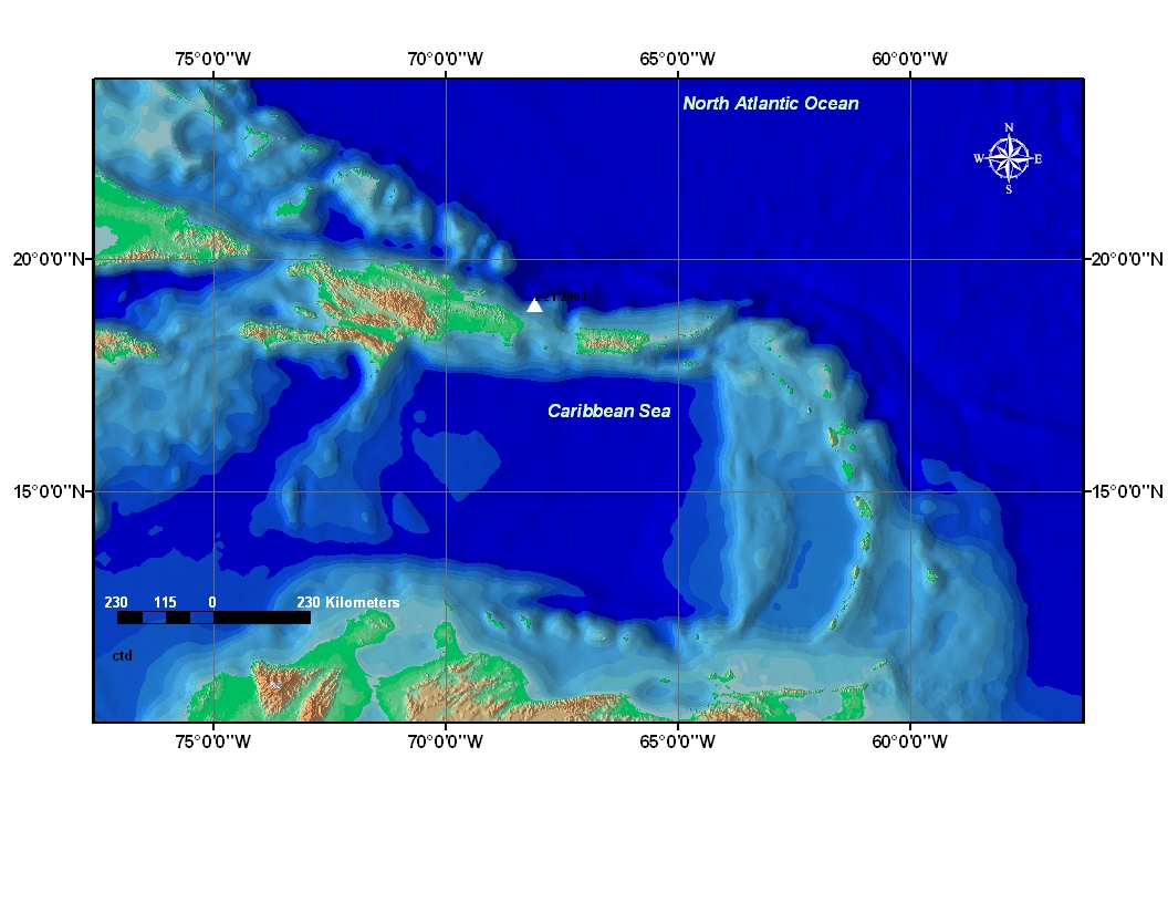
This data set shows the location where a CTD (Conductivity -Temperature - Depth) device was used. CTD were determined while in the Caribbean Sea. The point location attributes are longitude, latitude, and date of placement in the water; this information was acquired during the U.S. Geological Survey Science Cruise 03008 in collaboration with National Oceanic and Atmospheric Administration Research Cruise RB0303 from 18 February to 7 March 2003, Leg II of III. (Leg I and III: 20020924 to 20020930 and 20030828 to 20030904, respectively).
Purpose:
To derive sound velocity information used for sonar mapping calibration and to determine some water characteristics.
Time_Period_of_Content:
Time_Period_Information:
Range_of_Dates/Times:
Beginning_Date: 20030217
Ending_Date: 20030307
Currentness_Reference: ground condition
Status:
Progress: Complete
Maintenance_and_Update_Frequency: None planned
Spatial_Domain:
Bounding_Coordinates:
West_Bounding_Coordinate: -68.091670
East_Bounding_Coordinate: -68.091670
North_Bounding_Coordinate: 19.009730
South_Bounding_Coordinate: 19.009730
Keywords:
Theme:
Theme_Keyword_Thesaurus: General
Theme_Keyword: CTD
Theme_Keyword: Conductivity
Theme_Keyword: Seabird SBE-9+
Theme_Keyword: USGS
Theme_Keyword: CMGP
Theme_Keyword: location
Theme_Keyword: point shapefile
Theme_Keyword: USGS Cruise 03008
Theme_Keyword: NOAA Cruise RB0303
Theme_Keyword: NOAA
Theme_Keyword: U.S. Geological Survey
Theme_Keyword: Coastal and Marine Geology Program
Theme_Keyword: National Oceanic and Atmospheric Administration
Place:
Place_Keyword_Thesaurus: General
Place_Keyword: North America
Place_Keyword: North Atlantic Ocean
Place_Keyword: Puerto Rico
Place_Keyword: Atlantic Ocean
Place_Keyword: Caribbean Sea
Place_Keyword: Puerto Rico Trench
Access_Constraints: None
Use_Constraints:
Public domain data from the U.S. government are freely redistributable with proper metadata and source attribution. Please recognize the U.S. Geological Survey (USGS) as the source of this information.
Point_of_Contact:
Contact_Information:
Contact_Person_Primary:
Contact_Person: Chris Polloni
Contact_Organization: U.S. Geological Survey
Contact_Position: Information Specialist
Contact_Address:
Address_Type: mailing and physical address
Address: 384 Woods Hole Road
City: Woods Hole
State_or_Province: MA
Postal_Code: 02543-1598
Country: USA
Contact_Voice_Telephone: (508) 548-8700 x2280
Contact_Facsimile_Telephone: (508) 457-2310
Contact_Electronic_Mail_Address: cpolloni@usgs.gov
Hours_of_Service: 8:00AM to 5:00PM; M-F
Native_Data_Set_Environment:
Microsoft Windows 2000 Version 5.1 (Build 2600) Service Pack 2; ESRI ArcCatalog 8.3.0.800

Data_Quality_Information:
Completeness_Report: complete
Positional_Accuracy:
Horizontal_Positional_Accuracy:
Horizontal_Positional_Accuracy_Report:
The GPS was considered to have a horizontal accuracy of < 10 meters.
Vertical_Positional_Accuracy:
Lineage:
Source_Information:
Source_Time_Period_of_Content:
Source_Currentness_Reference: ground condition
Process_Step:
Process_Description:
The CTD data file was received from the R/V Ron Brown Oceanographic data network, sent directly to the central storage system and logged to a spreadsheet file.
Process_Date: 2004
Process_Contact:
Contact_Information:
Contact_Organization_Primary:
Contact_Organization: U.S. Geological Survey
Contact_Person: Chris Polloni
Contact_Position: Information Specialist
Contact_Address:
Address_Type: mailing and physical address
Address: 384 Woods Hole Road
City: Woods Hole
State_or_Province: Massachusetts
Postal_Code: 02543-1589
Country: USA
Contact_Voice_Telephone: (508) 548-8700 x2280
Contact_Facsimile_Telephone: (508) 457-2310
Contact_Electronic_Mail_Address: cpolloni@usgs.gov
Hours_of_Service: 8AM to 5PM; M-F
Process_Step:
Process_Description:
The CTD spreadsheet file was reformatted as table input file for ArcView.
Process_Date: 2004
Process_Contact:
Contact_Information:
Contact_Person_Primary:
Contact_Person: Chris Polloni
Contact_Organization: U.S. Geological Survey
Contact_Position: Information Specialist
Contact_Address:
Address_Type: mailing and physical address
Address: 384 Woods Hole Road
City: Woods Hole
State_or_Province: Massachusetts
Postal_Code: 02543-1589
Country: USA
Contact_Voice_Telephone: 508-457-2280
Contact_Facsimile_Telephone: (508) 457-2310
Contact_Electronic_Mail_Address: cpolloni@usgs.gov
Process_Step:
Process_Description:
CTD table location file saved as ArcView shapefile. ArcView 3.2 used to process shapefile.
Process_Date: 2004
Source_Produced_Citation_Abbreviation: ctd.dbf
Source_Produced_Citation_Abbreviation: ctd.shp
Source_Produced_Citation_Abbreviation: ctd.shx
Process_Contact:
Contact_Information:
Contact_Person_Primary:
Contact_Person: Chris Polloni
Contact_Organization: U.S. Geological Survey
Contact_Position: Information Specialist
Contact_Address:
Address_Type: mailing and physical address
Address: 384 Woods Hole Road
City: Woods Hole
State_or_Province: Massachusetts
Postal_Code: 02543-1589
Country: USA
Contact_Voice_Telephone: (508) 548-8700
Contact_Facsimile_Telephone: (508) 457-2310
Contact_Electronic_Mail_Address: cpolloni@usgs.gov
Hours_of_Service: 8AM to 5PM; M-F

Spatial_Data_Organization_Information:
Direct_Spatial_Reference_Method: Vector
Point_and_Vector_Object_Information:
SDTS_Terms_Description:
SDTS_Point_and_Vector_Object_Type: Entity point
Point_and_Vector_Object_Count: 1

Spatial_Reference_Information:
Horizontal_Coordinate_System_Definition:
Geographic:
Latitude_Resolution: 0.000001
Longitude_Resolution: 0.000001
Geographic_Coordinate_Units: Decimal degrees
Geodetic_Model:
Horizontal_Datum_Name: D_WGS_1984
Ellipsoid_Name: WGS_1984
Semi-major_Axis: 6378137.000000
Denominator_of_Flattening_Ratio: 298.257224
Vertical_Coordinate_System_Definition:
Altitude_System_Definition:
Depth_System_Definition:

Entity_and_Attribute_Information:
Detailed_Description:
Entity_Type:
Entity_Type_Label: CTD
Entity_Type_Definition: Shapefile Attribute Table
Entity_Type_Definition_Source: ESRI
Attribute:
Attribute_Label: FID
Attribute_Definition: Internal feature number.
Attribute_Definition_Source: ESRI
Attribute_Domain_Values:
Unrepresentable_Domain:
Sequential unique whole numbers that are automatically generated.
Attribute:
Attribute_Label: Shape
Attribute_Definition: Feature geometry.
Attribute_Definition_Source: ESRI
Attribute_Domain_Values:
Unrepresentable_Domain: Coordinates defining the features.
Attribute:
Attribute_Label: ID
Attribute_Definition:
a unique character string or numeric value associated with a particular object.
Attribute_Definition_Source: ESRI
Attribute:
Attribute_Label: LATITUDE
Attribute_Definition:
The north/south geographic coordinate reference point (location) where the CTD device was placed in water.
Attribute_Definition_Source: NOAA shipboard technician
Attribute:
Attribute_Label: LONGITUDE
Attribute_Definition:
The east/west geographic coordinate reference point (location) where the CTD device was placed in water.
Attribute_Definition_Source: NOAA shipboard technician
Attribute:
Attribute_Label: WAYPTS
Attribute_Definition: Name assigned to designate CTD cast start location
Attribute_Definition_Source: User defined
Attribute_Domain_Values:
Enumerated_Domain:
Enumerated_Domain_Value: CTD
Enumerated_Domain_Value_Definition: CTD (Conductivity - Temperature - Depth) device
Enumerated_Domain_Value_Definition_Source: USGS
Attribute:
Attribute_Label: DATE
Attribute_Definition:
The recorded date by month, day, and year, mm:dd:yyyy, when the device/equipment was lowered into the water
Attribute_Definition_Source: User defined
Attribute_Domain_Values:
Unrepresentable_Domain: Character string in the format of mm/dd/yyyy
Attribute:
Attribute_Label: TIME
Attribute_Definition:
The recorded time by hour:minute:second, hh:mm:ss, when the device/equipment was lowered into the water
Attribute_Definition_Source: User defined
Attribute_Domain_Values:
Unrepresentable_Domain: Character string in the format of hh:mm:ss
Overview_Description:
Entity_and_Attribute_Overview:
This is an ArcView table that shows attribute information of longitude, latitude, and date that this CTD device was temporarily placed at a location.

Distribution_Information:
Distributor:
Contact_Information:
Contact_Person_Primary:
Contact_Person: Uri ten Brink
Contact_Organization: U.S. Geological Survey
Contact_Position: Research Geologist
Contact_Address:
Address_Type: mailing and physical address
Address: 384 Woods Hole Road
City: Woods Hole
State_or_Province: Massachusetts
Postal_Code: 02543-1589
Country: USA
Contact_Voice_Telephone: (508) 548-8700 x2396
Contact_Facsimile_Telephone: (508) 457-2310
Contact_Electronic_Mail_Address: utenbrink@usgs.gov
Hours_of_Service: 8AM to 5PM; M-F
Resource_Description: Downloadable Data: Open-File Report 2004-1400 - ctd
Distribution_Liability:
Although this dataset has been used by the U.S. Geological Survey, no warranty, expressed or implied, is made by the USGS as to the accuracy of the data and/or related materials. The act of distribution shall not constitute any such warranty, and no responsibility is assumed by the USGS in the use of these data or related materials.
Standard_Order_Process:
Digital_Form:
Digital_Transfer_Information:
Format_Name: ArcView shapefile
Format_Version_Number: 3.2
Format_Specification: ESRI polygon shapefile
Format_Information_Content:
The six files (ctd.dbf, ctd.prj, ctd.shp, ctd.shx, ctd_metadata.txt, and ctd.xml)
File_Decompression_Technique: zip
Transfer_Size: 7
Digital_Transfer_Option:
Offline_Option:
Offline_Media: DVD-ROM
Recording_Capacity:
Recording_Density: 4,700
Recording_Density_Units: Mbyte
Recording_Format: UDF
Compatibility_Information:
The user must have a computer system with a DVD-ROM available. To browse the information contained on this CD-ROM, the user must have a current WWW browser available. The user must also have software installed on their computer to unzip the archived file.
Fees: none
Technical_Prerequisites:
The data is available in Environmental Systems Research Institute, In. (ESRI) shapefile format. The user must have ArcView 3.x, ArcGIS 8.x or greater equivalents of either software to read and process the data file. In lieu of ArcView/ArcGIS, the user may utilize another GIS application package capable of importing data.

Metadata_Reference_Information:
Metadata_Date: 20041102
Metadata_Contact:
Contact_Information:
Contact_Person_Primary:
Contact_Person: Glynn Williams
Contact_Organization: U.S. Geological Survey
Contact_Position: Spatial Data Technician
Contact_Address:
Address_Type: physical address
Address: 384 Woods Hole Road
City: Woods Hole
State_or_Province: Massachusetts
Postal_Code: 02543-1598
Country: USA
Contact_Voice_Telephone: (508) 548-8700.x2290
Contact_Facsimile_Telephone: (508) 457-2310
Contact_Electronic_Mail_Address: gwilliams@usgs.gov
Hours_of_Service: 8:00AM to 5:00PM; M-F
Metadata_Standard_Name: FGDC Content Standards for Digital Geospatial Metadata
Metadata_Standard_Version: FGDC-STD-001-1998
Metadata_Time_Convention: local time
Metadata_Access_Constraints: None
Metadata_Use_Constraints: None
Metadata_Extensions:
Online_Linkage: <http://www.esri.com/metadata/esriprof80.html>
Profile_Name: ESRI Metadata Profile
Metadata_Extensions:
Online_Linkage: <http://www.esri.com/metadata/esriprof80.html>
Profile_Name: ESRI Metadata Profile

Generated by mp version 2.7.33 on Tue Dec 21 17:14:41 2004