 |
|
|
||||
| U.S. Geological Survey Open-File Report 2004-1445 |
By
E.
L. Rowan, R. T. Ryder, J. E. Repetski,
M. H. Trippi, and L. F. Ruppert
| A
preliminary model of burial/thermal
history and hydrocarbon
generation
is presented for a regional-scale
(354 km) geologic cross
section
oriented approximately
perpendicular
to the Appalachian basin
axis. The section extends
through relatively undeformed
strata, from the Rome trough
in central West Virginia,
northwestward to the Findlay
arch in northwestern Ohio.
The model incorporates
sedimentation,
compaction, uplift, and
erosion,
and assumes a constant
basement
heat flow of 60 mW/m2.
Relatively low
thermal conductivities
are
assigned to coals (0.2
W/m°C)
and to kerogen-rich black
shales
(0.9 W/m°C).
Thermal maturity measurements
of conodont color alteration
index (CAI) and vitrinite
reflectance (Ro%) from
Ordovician,
Devonian, and Pennsylvanian
rocks
constrain the model.
Even
with the low thermal
conductivities,
the model requires the
deposition
of additional Permo-Triassic
sediment, subsequently
removed
by erosion, in order
to match measured thermal
maturity
values. In this model,
maximum
burial is assumed
to have occurred at
the end
of the Middle Triassic
(230
m.y.), with deposition
of
a
wedge of Permo-Triassic
sediment.
The added sediment is
7200
ft (2195 m) thick at
the southeast end of
the section,
thins to the northwest,
and
pinches out at the western
margin
of the basin. The additional,
modeled, Permo-Triassic
sediment
is completely eroded
by present
day, leaving only the
current,
measured formation thicknesses.
An important goal of the study is to predict the timing of thermal maturation of key hydrocarbon source rocks. We present calculations for two source rock intervals, Middle-Upper Devonian shales and the Ordovician Utica Shale. The Devonian shales have generated predominantly gas and lesser amounts of oil. These hydrocarbons are trapped in sandstones of Devonian and Mississippian age as well as in fractured intervals of Devonian shale. The Utica Shale is a 100-200 ft (30-60 m) thick, laterally extensive, source rock that generated petroleum that is now trapped in Cambrian-Silurian carbonates and sandstones. DOWNLOAD THE REPORT [13.1-MB PDF FILE] |
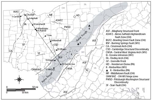 Locations of some of the major structural and geologic features in the vicinity of the model cross section. |
| AccessibilityFOIAPrivacyPolicies and Notices | |
 |
|