![]()
Digital Mapping Techniques '04— Workshop Proceedings
U.S. Geological Survey Open-File
Report 2004–1451
Science Language, Parsing and Querying: The Surficial Side of Things*
1Geological Survey of Canada, GSC-Québec, 490 de la Couronne, Québec, Canada G1K 9A9; Telephone: (418) 654-2635; Fax: (418) 654-2615ABSTRACT
Communicating geological concepts amongst geologists as well as from geologists to the general public requires that a well established and documented science language be available. This task is tackled by various groups that have an interest in making available geological data to a broad community. This paper focuses on science language needed to adequately represent geological concepts portrayed on surficial geology maps in Canada. Words necessary to describe glacial and ice-contact deposits, environments, landforms, etc., have been extracted from map legends. They have been organized hierarchically under high level concepts such as earth materials, physical characteristics, and genesis. The science language will be an evolving tool used by geologists and the general public. Therefore, it needs to have the flexibility to accommodate modifications under the supervision of an expert committee to insure that such modifications are made according to the accepted philosophy.
INTRODUCTION
Words are a powerful tool for communication, if the definition of the word is agreed upon by all users. Too many times do we hear: “in this context, we use the word (insert your choice) to mean (a definition of the word).” With the advent of digital mapping, it has become more and more important to develop common terminologies in order to facilitate the querying of maps by knowledgeable and lay users of geological information. The Science Language Technical Teams of the North America Data Model Steering Committee (http://nadm-geo.org/) have undertaken this very task. We will refer to reports by the Science Language Technical Team on Sedimentary Materials (North American Geologic Map Data Model Science Language Technical Team, 2003 and their paper in this volume) as needed, using the acronym “SLTTS_1.0”.
Traditionally, surficial geology has been regarded as a completely separate geological topic, especially in Canada where it is largely equivalent to Quaternary glacial geology. This is not rigidly enforced, and one could rightly argue that recently erupted lavas are surficial materials. There remain problematic issues (pyroclastic materials are a good example) that will not be resolved here. Rather, we will treat this subject from a Canadian surficial geological map point of view, recognizing that it is incomplete. The main objective of this paper is to present the science language that is being used with the parsing and querying tools currently under development at the Geological Survey of Canada (GSC).
Recently, the point has been made that surficial geology describes unconsolidated earth material of sedimentary origin. Glacial geology is thus a subset of sedimentary geology where the sedimentation agent is ice, rather than water or wind, although both (water and wind) are involved in forming the materials and landscape of the ice contact environment. This clarification comes at a time when the GSC is developing web-based tools (http://cgkn.net/) to help a variety of geological data users to sort through the information available on maps (Moore and others, 2003). The challenge remains: providing a coherent science language adapted to surficial geology. Specialized terminology needed to adequately describe glacial deposits, especially landforms, had not yet been developed under SLTTS_1.0. We hope to contribute to science language development in North America by providing such terminology and a coherent classification scheme. The reader should keep in mind that the rest of this paper is focused on the ultimate GSC goal, parsing map legends (by the geologist) and querying the data (by any user).
THE SCIENCE LANGUAGE
The goal of the GSC is to develop a science language to be used in the parsing and querying of surficial geology maps, supported by a glossary of all terms used. The science language needs to adhere to a coherent classification scheme. It also should be intuitively simple enough for non-expert users (novice geologist-users as well as the general public), and complete enough for experienced users. For bedrock geology, the problem was tackled using NADM-C1 (2004) as a starting point (Davenport and others, 2002; Struik and others, 2002).
The group working on the science language for surficial geology adopted a “legend to science language” approach, similar to the one described in Thorleifson and Pyne (2003). As a starting point, we identified the science words most commonly used in surficial geology map legends, rather than using an already existing classification. The rationale behind this approach was to quickly provide users with a working science language that would cover most of the terminology used on maps. Following two pan-Canadian workshops, the results of this exercise were organised into a flat table, the heading of each column representing first order concepts such as depositional environment or sedimentary material. Quickly, it became clear that this simple schema was not satisfying if it was to be incorporated into SLTTS_1.0.
The next step was to look at the results of the legend analysis exercise and to compare it with SLTTS_1.0. A large proportion of the words readily found a niche in SLTTS_1.0. Words for earth materials, sedimentary structures, and, to a certain extent, depositional environments already existed. We put together a series of tables, each representing a high level concept (e.g., earth materials (Figure 1), physical characteristics (Figure 2), genesis (Figure 3)). Each of the tables then proposes a hierarchical classification of terminology into lower level concepts until the words resulting from the map legend analysis exercise were reached. In most cases, words from the legends were introduced on the 4th level or lower.
Earth Material
Earth material (“a naturally occurring substance formed in or on the Earth by physical, chemical, or biogenic processes that produce solid particles or crystals of mineral and (or) rock”; SLTTS_1.0 (NADM, unpublished document) is the starting point for all map unit descriptions. As shown in Figure 1, following SLTTS_1.0 philosophy, this first level concept is divided at level two according to the primary genetic process, into igneous, composite-genesis (includes metamorphic rocks), and sedimentary earth material. Sedimentary earth materials are further subdivided into consolidated sedimentary materials and unconsolidated sedimentary materials (level 3). Terminology for Quaternary glacial geology resides underneath the latter. Any older consolidated glacial deposits such as tillites would reside under consolidated sedimentary earth material. There is no need to introduce additional terminology for earth material, since sand is sand whether deposited by water, wind or ice. Therefore, for surficial geology science language needs, we extract from SLTTS_1.0 the subset of terms needed to adequately describe map units on surficial geology maps.
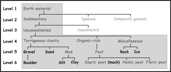 |
Figure 1. Classification of earth materials for surficial geology. The subset of words in the greyed area represents surficial glacial materials. Words in bold were either already in SLTTS_1.0 and in map legends, or they were added by the legend analysis exercise. |
However, a “miscellaneous” category was required to accommodate polygons that are identified as “bedrock” without further description, or ice, in areas where icefields and/or glaciers are large enough to be mapped. In the case of bedrock, we would suggest that the polygon, whenever possible, be identified at least to its 2nd level (sedimentary, igneous, or composite genesis) or 3rd level (general rock name) concept, and where possible, a link to the appropriate bedrock geology map (if web-available) should be included with the description of the polygon.
Because map units are rarely composed of a unique earth material, we suggest the use of a table of relative abundance (as proposed in NADM-C1, http://nadm-geo.org/) in conjunction with earth materials. The combination of the two tables would yield the information necessary to answer a data user query such as “Show me, in this region, places where the surficial deposits are mostly sand”.
Physical Characteristics
SLTTS_1.0 has proposed language to describe map unit characteristics. As shown in Figure 2, we have chosen to group under the first level concept of “physical characteristics” second level concepts such as outcrop characteristics, map-unit thickness, sedimentary fabric, and sedimentary structures. Descriptions of map units are usually qualitative, but there may be some quantitative information where there exists, for example, grain size analysis or others. Therefore, we offer the parser the choice between using qualitative terminology or quantitative terminology at the same level.
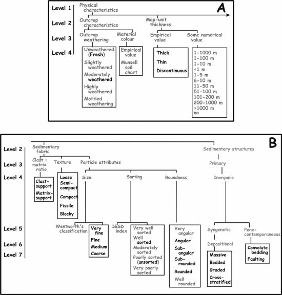 |
Figure 2. Classification of physical characteristics for surficial geology: A) Outcrop characteristics and map-unit thickness; B) Sedimentary fabric and sedimentary structures. Words in bold were either already in SLTTS_1.0 and in map legends, or they were added by the legend analysis exercise. It is possible to provide some choices for “material colour” such as grey(ish), yellow(ish), red(dish), etc. if the Munsell chart is not used. The distinction between map-unit thickness values “thick” and “thin” will need to be decided by the CGKN stewardship committee. Although “thin” is usually associated with “discontinuous”, i.e. with numerous bedrock outcrops found in the deposit, it may actually be continuous and range from less than 1m to 5 m depending on the map maker. |
Sedimentary structures are an important aspect of all sedimentary materials, but perhaps because surficial geology is partly done via air-photo interpretation, descriptions of sedimentary structures are rarely included, or briefly mentioned, in surficial geology map legends. When this information is provided in the map legend, it can be captured using SLTTS_1.0 proposed hierarchy, following the path: sedimentary structures → primary → inorganic → syngenetic (or penecontemporaneous) and depositional (or erosional) structures (Figure 2B). Again, because this paper provides science language derived from the analysis of map legends, Figure 2 only shows a very restricted number of words, but all the terminology proposed in SLTTS_1.0 is available as needed.
There are a number of features that may be grouped under secondary sedimentary structures, like those produced by the growth of ground ice. Because the development of such features is normally of a scale large enough to allow mapping of individual features, we suggest that these may be better classified as landforms. Micro-landforms such as striation could also be argued to be secondary sedimentary structures imposed on bedrock surfaces. We prefer, however, to include these in glacial landforms, where they more intuitively belong.
Genesis
Considerable attention in SLTTS_1.0 has been given to the high level concept of genesis. Depositional processes, environments, and products are three interrelated second level concepts; in Figure 3 the hierarchy of glacial processes and environments are shown. We would like to introduce a fourth concept, landforms, in order to address the needs of surficial geologists (Figure 4). The rationale is as follows.
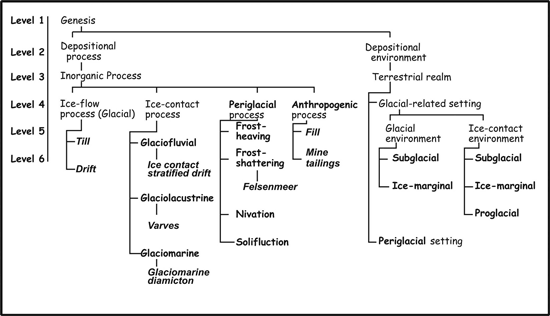 |
Figure 3. The high-level concept of “genesis” and its constituents, processes and environments. Words in bold-italics represent depositional products, and words in bold were either already in SLTTS_1.0 and in map legends, or they were added by the legend analysis exercise. |
|
GLACIAL PROCESS
|
ICE-CONTACT PROCESS
|
PERIGLACIAL PROCESS
|
||||
|---|---|---|---|---|---|---|
|
Subglacial
|
Ice-marginal
|
Subglacial
|
Ice-Marginal
|
Perenially frozen
|
Extreme cold temperatures
|
|
| Plain | Cover moraine, veneer | Outwash plain | ||||
| Cover moraine, blanket | Kame terrace | |||||
| Cover moraine, undulating | Apron | |||||
| Ridge (stream- lined drift) |
Flute | Flute | ||||
| Drumlinoid | Drumlinoid | |||||
| Drumlin | Drumlin | |||||
| Crag-and-tail | Streamlined drift | |||||
| Till ramp | ||||||
| Ridge (stream- lined bedrock) |
Rock drumlin (whaleback) | |||||
| Roche moutonnée | ||||||
| Rat-tails | ||||||
| Ridges (drift, not stream- lined |
Ribbed (Rogen) moraine | Terminal moraine | Crevasse filling | Ice-wedge polygons | ||
| DeGeer moraines | Frontal moraine | Esker | ||||
| Thrust moraines |
Recessional moraine Lateral moraine Interlobate moraine |
|||||
| Mound | Hummocky moraine | Kame | Outwash fan | Pingo | Solifluction lobe | |
| Subwash | Palsa | Sorted circles | ||||
| Depression | Cirque | Channel | ||||
| Glacial flow | Kettle | |||||
| U-shaped trough | ||||||
| Fjord | ||||||
| Glacial-lake basin | ||||||
| Striation | ||||||
| Figure 4. Glacial, ice-contact, and periglacial landforms. All the words found in this table were added by the map legend analysis exercise. |
We believe that depositional products (the map unit itself) and the landform (of which there may be one or more within a map unit) are both the direct results of a depositional process taking place in an environment. In the most simple case, the landform is a flat plain that does not contribute very much to the description of the map unit or the interpretation of the map. In the most complex case, a map unit would host many landforms that result from interrelated processes, such as the association of recessional moraines with kames and kettles (ridges, mounds and depressions to speak in non-genetic terms).
In devising the hierarchy for depositional processes and environments related to a glacial setting, we were inspired by the comprehensive work produced by the Commission on Genesis and Lithology of Glacial Quaternary Deposits of the International Union for Quaternary Research [INQUA] (in Goldthwait and Matsch, 1988), specifically those papers by Dreimanis (1988), Goldthwait and others (1988), and Lundqvist (1988). We subdivide ice flow processes and environments into “glacial” (requiring the direct action of glacial ice; Lundqvist, 1988) and “ice-contact” rather than “glacigenic” (processes, depositional environments, deposits or landforms that require glacial ice, but not necessarily directly related to it; Lundqvist, 1988). We prefer the term “ice-contact” because it is in common usage amongst glacial mappers. Under “ice-contact”, we find concepts such as glaciofluvial, glaciolacustrine and glaciomarine. We also introduce the concept of “periglacial” processes and environments for those regions where extreme cold conditions result in unique depositional products and landforms.
Clearly, the dividing line between glacio (fluvial-lacustrine-marine) and strictly fluvial-lacustrine-marine terminology requires some thought. It has been argued amongst members of the SLTTS working group that processes and environments outside of a glacier already have terminology and descriptions. Fluvial processes are the same whether the water comes from direct precipitation or from the melting of glacier ice. Similarly, lacustrine and marine processes/environments exist whether in contact with a glacier or not. Therefore, these should not be duplicated under “ice flow processes”, or “glacial-related settings”. Perhaps a multihierarchical classification, such as proposed in Struik and others (2002) would better serve this complex concept of genesis.
We believe there is a logical reason to address glaciofluvial, glaciolacustrine and glaciomarine processes/environments separately, because there are some unique features associated with them. For example, landforms such as eskers and kames are not formed without the presence of glacial ice. Similarly, deposits such as varves and glaciomarine diamictons will not be formed in non-glacial lacustrine/marine environments. We thus use in Figure 4 some specialized terminology related to those transitional environments, where the “glacio-” component is critical in the development of deposits and landforms. Because there is a continuous evolution between the glacially-influenced and the non-glacially influenced, the distinction is seldom evident in surficial geology map legends. This paper will not address the non-glacial fluvial, lacustrine and marine processes/environments that are present on surficial geology maps, as we recognize that the terminology and hierarchy provided by SLTTS_1.0 satisfies our needs.
Two more concepts need to be introduced to adequately capture the information on surficial geology map legends: periglacial and anthropogenic. We use Lundqvist’s (1988) definition of the term periglacial. It encompasses processes, depositional environments, deposits or landforms “caused by cold climate and thus often occurring outside a glacier but not requiring its presence”.
From the Glossary of Geology (Jackson, 1997), periglacial is more narrowly defined as “said of the processes, conditions, areas, climates, and topographic features at the immediate margins of former and existing glaciers and ice sheets, and influenced by the cold temperature of the ice”. This definition is extended to include “an environment in which frost action is an important factor, or of phenomena induced by a periglacial climate beyond the periphery of the ice” (Jackson, 1997). This extension of the term “periglacial” might include features that do not require perennially frozen ground, but that do require extreme cold temperatures.
We believe that the heading “cryogenic” (processes, depositional environments, deposits or landforms that are related to extreme cold conditions including but not restricted to perennially frozen grounds) should be the higher-level concept under which periglacial (requiring perennially frozen grounds) and extreme cold climate would reside. Whether this distinction is needed is open to discussion. This is why Figures 3 and 4 do not reflect this thinking. Similarly, how we choose the cut-off percentage for the volume of ground ice required before a process, depositional environment, deposit, or landform is classified under periglacial needs to be fine-tuned. We offer language to at least cover the terminology found in map legends. We will need to address this issue with expert references such as those available at the Frozen Ground Data center web site (http://nsidc.org/fgdc/glossary/description.html), and specifically Everdingen (1998).
Finally, a concept that also requires some thought is the action of man on its environment. Anthropogenic processes result in such deposits as fill or mine tailings, which are important mappable units, especially where they conceal the underlying geology.
CONCLUSIONS
Science language development is not a minor task. Those involved in this effort each have a different view of the hierarchy and organisation of the terminology depending on their professional background. A carefully considered philosophy brings together ideas and concepts into a largely accepted consensus from which the science language is built. This is by no means a static issue. Users will need to work with the proposed science language and offer suggestions to improve its usefulness. Discussions will result in modifications, minor and perhaps major, which will lead to a new release of the science language. In order to facilitate this process, the GSC has established a stewardship policy (http://cgkn.net/2002/working/surficial_e.htm; see Appendix for the description of the CGKN working group on surficial materials).
The progress report that we present here shows the situation at the GSC regarding surficial geology. Future versions of this science language will most likely include more specialized terminology, and perhaps change the classification scheme somewhat in order to better comply to SLTTS_1.0. We welcome discussion and comments on this proposition. We also believe that we need to publicly discuss our thought processes and science language so that potential users can critically comment on it. We think the approach we have taken will satisfy users’ needs and allow the geologists to find the terminology they want to use. It will take some time before we are all comfortable with the science language and its use, but it is a powerful tool for earth scientists and for decision-making authorities, planners, and the general public.
ACKNOWLEDGMENTS
This work is being carried out by the authors under, and financially supported by, project GK4350 “Integrated Information System for Bedrock, Surficial, Geochronological, Stratigraphic and Paleontological Data” of the program “Consolidating Canada’s Geoscience Knowledge” of the Earth Science Sector, Natural Resources Canada. We wish to acknowledge the numerous discussions we have had with our colleagues, as well as Dr. Alain Plouffe for critically reviewing this manuscript. The first author has nagged repeatedly some specific individuals, Éric Boisvert of GSC-Québec, Peter Davenport of GSC-Calgary, and Jonathan Matti of the USGS. Thank you all!
REFERENCES
Davenport, P., Boisvert, É., Quat, M., Okulitch, A., Brodaric, B., Colman-Sadd, S., Noland, L., Struick, B., MacIntyre, D., Tzeng, P., Scott, D., Gilbert, C., Abbott, G., Bassan, A., Journeay, M., Francis, J., Houlahan, T., 2002, A Scalable, Digital Map Database of Bedrock Geology for Canada: A Progress Report, in Soller, D.R., ed., Digital Mapping Techniques ’02—Workshop Proceedings, U.S. Geological Survey Open-file Report 02–370, p. 54–73, accessed at http://pubs.usgs.gov/of/2002/of02-370/.
Dreimanis, A., 1988, Tills: their genetic terminology and classification, in Goldthwait, R.P., and Matsch, C.L., eds., Genetic classification of glacigenic deposits (Final report of the Commission on Genesis and Lithology of Glacial Quaternary Deposits of the International Union for Quaternary Research [INQUA]): Rotterdam, A.A. Balkema, p. 17–83.
Everdingen, Robert van, ed., 1998 revised January 2002, Multi-language glossary of permafrost and related ground-ice terms: Boulder, CO, National Snow and Ice Data Center/World Data Center for Glaciology, accessed at http://nsidc.org/fgdc/glossary/description.html.
Goldthwait, R.P., and Matsch, C.L., eds., 1988, Genetic classification of glacigenic deposits (Final report of the Commission on Genesis and Lithology of Glacial Quaternary Deposits of the International Union for Quaternary Research [INQUA]): Rotterdam, A.A. Balkema, 294 p.
Goldthwait, R.P., Matsch, C.L., and Dreimanis, A., 1988, Preface, in Goldthwait, R.P., and Matsch, C.L., eds., Genetic classification of glacigenic deposits (Final report of the Commission on Genesis and Lithology of Glacial Quaternary Deposits of the International Union for Quaternary Research [INQUA]): Rotterdam, A.A. Balkema, p. vii–ix.
Jackson, J.A., 1997, Glossary of geology, 4th ed.: Alexandria, Virginia, American Geological Institute, 769 p.
Lundqvist, J., 1988, Glacigenetic processes, deposits, and landforms, in Goldthwait, R.P., and Matsch, C.L., eds., Genetic classification of glacigenic deposits (Final report of the Commission on Genesis and Lithology of Glacial Quaternary Deposits of the International Union for Quaternary Research [INQUA]): Rotterdam, A.A. Balkema, p. 3–16.
Moore, A., Dilabio, R., Thorleifson, H., Matile, G., Pyne, M., Murray, R. and Bolduc, A., 2003, Developing and deploying a surficial Geology Science Language: Geological Society of America Abstracts with Programs, No 6, September 2003, p. 278, accessed at http://gsa.confex.com/gsa/2003AM/finalprogram/abstract_66536.htm.
North American Geologic Map Data Model Science Language Technical Team, 2003, Science Language for Geologic-Map Databases in North America: A Progress Report, in Soller, D.R., ed., Digital Mapping Techniques ’03—Workshop Proceedings: U.S. Geological Survey Open-file Report 03–471, p.109–138, accessed at http://pubs.usgs.gov/of/2003/of03-471/matti/index.html.
North American Geologic Map Data Model Steering Committee, 2004, NADM Conceptual Model 1.0, A Conceptual Model for Geologic Map Information: preliminary website release under the auspices of the Geological Survey of Canada, the U.S. Geological Survey, and the Association of American Geologists, accessed at http://nadm-geo.org/.
North American Geologic Map Data Model Steering Committee, unpublished document, Sedimentary materials: science language for their classification, description, and interpretation in digital geologic-map databases, Version 1.0.
Struik, L.C., Quat, M.B., Davenport, P.H., Okulitch, A.V., 2002, A preliminary scheme for multihierarchical rock classification for use with thematic computer-based query systems: Geological Survey of Canada Current Research, 9 p., accessed at http://geoscan.ess.nrcan.gc.ca/cgi-bin/starfinder/20479/geoscan_f.txt.
Thorleifson, L. H. and Pyne, D. M. 2003, Conversion of lithological data in the Manitoba water well database (GWDrill) to a mappable format, in Soller, D.R., ed., Digital Mapping Techniques ‘03—Workshop Proceedings: U.S. Geological Survey Open-file Report 03-471, p. 139–156, accessed at http://pubs.usgs.gov/of/2003/of03-471/thorleifson/index.html.