
Digital Mapping Techniques '04— Workshop Proceedings
U.S. Geological Survey Open-File
Report 2004–1451
Brownfield and Contaminated Site Remediation: Historic Fill Series
New Jersey Department of Environmental Protection, New Jersey Geological Survey, 29 Arctic Parkway, P.O. Box 427, Trenton, NJ 08625-0427; Telephone: (609) 292-2576; Fax: (609) 633-1004; e-mail: mike.girard@dep.state.nj.usThe “Brownfield and Contaminated Site Remediation Act” (P. L. 1997, c. 278) requires the New Jersey Department of Environmental Protection (the New Jersey Geological Survey’s parent agency) to map regions of the state where large areas of historic fill exist, and make this information available to the public. The legislation defines “historic fill material” as “large volumes of non-indigenous material… used to raise the topographic elevation of a site” (N.J.S.A. 58:10B–12(h)1). Fill is mapped on USGS 7.5-minute topographic quadrangle maps (1:24,000-scale) by analyzing landforms using stereo aerial photography, and by comparing areas of swamp, marsh, and floodplain shown on archival (ca. 1840–1880) topographic and geologic maps to their extent as shown on the most recent map. In a few places, fill is mapped from field observations and from driller’s logs of wells and borings. Most areas of fill larger than about 5 acres can be identified and mapped using this method. The Historic Fill Map Series has been digitized in ESRI’s ArcEdit software at a scale of 1:24,000 and compiled with ESRI’s ArcInfo and Adobe Illustrator software. Historic Fill of the Elizabeth Quadrangle (HFM–52 and Figure 1) was mapped by S.D. Stanford of the New Jersey Geological Survey in 2001.
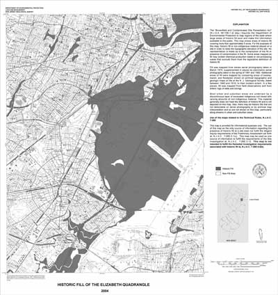 |
Figure 1. New Jersey Geological Survey Map HFM–52, Historic Fill of the Elizabeth Quadrangle. |