
Digital Mapping Techniques '04— Workshop Proceedings
U.S. Geological Survey Open-File
Report 2004–1451
Geology, Stewart River Area (Parts of 115 N/1,2,7,8 and 115-O/2-12), Yukon Territory
Geological Survey of Canada, 101-605 Robson Street, Vancouver, B.C., Canada V6B 5J3; Telephone: (604) 666-2116; Fax: (604) 666-1124; e-mail: sgordey@nrcan.gc.caINTRODUCTION
Geological mapping in the Stewart River area (NTS 115 N, O, in the Yukon along the Alaska border) began as part of the Ancient Pacific Margin NATMAP Project. Initiated by the Geological Survey of Canada, Yukon Geological Survey, and British Columbia Geological Survey Branch, the NATMAP Project seeks to improve understand of the composition, relationships, and metallogeny of terranes lying between the ancestral North American margin and those known with more certainty to be tectonically accreted (Thompson and others, 2000; Colpron and others, 2001). The Stewart River component (Figure 1) focuses on the Yukon-Tanana terrane (Mortensen, 1990 and 1992), comprising complexly deformed, mostly (?) Paleozoic meta-igneous and metasedimentary rocks. The final two years of the Stewart River Project are funded under the Geological Survey of Canada’s Northern Resources Development Program.
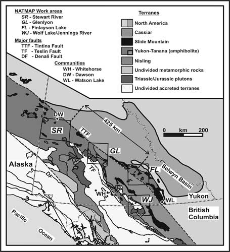 |
Figure
1. Regional tectonic
setting of the Stewart River area. |
The objective of the Stewart River Project is to investigate the stratigraphic, structural, and tectonic history, and the economic framework, of this large tract of Yukon-Tanana terrane by mapping about 2/3 of the area over a four year period. Geology is being interpreted in light of new geophysical data collected in this area under the Targeted Geoscience Initiative (Figure 2; Shives and others, 2002). Concurrent surficial geological studies were aimed at understanding the Quaternary history and setting of the numerous placer gold deposits in the region (e.g. Jackson and others, 2001, 2002; Rotheisler and others, 2003).
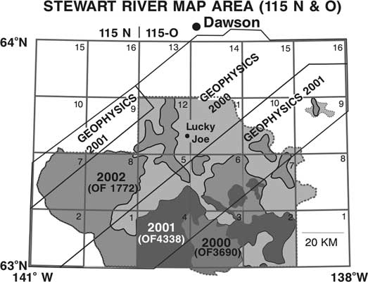 |
Figure
2. Cumulative progress
of bedrock mapping in the Stewart River area (reference to previous Geological
Survey of Canada open file reports are in parentheses). The grid outlines
1:50 000 NTS boundaries. Helicopter-borne detailed aeromagnetic and gamma-ray
surveys (gray areas denoted as “Geophysics <date>”) were flown in
2000 and 2001. |
In summer 2003, gaps in the previous mapping were bridged and the mapping extended to cover about eleven 1:50 000 scale map areas (see Figure 2). These new data and previous work in surrounding areas (e.g. Bostock, 1942; Tempelman-Kluit, 1974; Mortensen, 1996) will be synthesized into a new geological map of the Stewart River map area (1:250,000 scale; 115N–O).
Access into the heart of the Stewart River area is afforded by boat along the Yukon and Stewart rivers and by truck on placer mining roads, many of which extend south from Dawson. Fieldwork in 2000-2003 included foot traverses from small camps mobilized along these routes and from helicopter or fixed-wing supported camps in more remote areas. All-terrain vehicles were used on placer mining access roads along Thistle, Kirkman, Henderson, Black Hills and Maisy Mae creeks and the Sixty Mile River. Helicopter spot checks were used to fill in widely separated outcrops in the southwest part of the map area where foot traverses or fly camps were impractical. Bedrock mapping is hampered by a deep (~1 m) soil veneer, thick gravel, and loess deposits in valley bottoms, and by dense cover of forest, moss, and lichen. The detailed aeromagnetic and gamma-ray surveys (Shives and others, 2002) are an effective aid to bedrock mapping in this poorly exposed, unglaciated terrain.
GEOLOGICAL FRAMEWORK
The Stewart River area is underlain by twice-transposed, amphibolite-facies gneiss and schist of mostly (?) Paleozoic age. These are intruded by younger plutonic rocks and overlain by Upper Cretaceous volcanic rocks and local occurrences of Lower Cretaceous conglomerate. The reader is directed to Ryan and Gordey (2001a, b; 2002a, b) and Ryan and others (2003) for a more comprehensive description of the geology.
Metasiliciclastic rocks are widespread, and dominated by psammite and quartzite, with lesser pelites and rare conglomerate. These were thought to be as old as late Proterozoic (e.g. Tempelman-Kluit, 1974); however, preliminary detrital zircon geochronology and geochronology for plutonic rocks suggest a middle Paleozoic age (M. Villeneuve, Geological Survey of Canada, in preparation). Intermediate to mafic composition amphibolite interdigitates with, and lies stratigraphically above, the siliciclastic rocks. Although intensely tectonized, heterogeneous compositional layering and local vestiges of primary textures in the amphibolite, such as breccia clasts and pillow selvages, indicate derivation from volcanic and volcaniclastic rocks. Marble horizons occur within the amphibolite, as well as the siliciclastic rocks. In turn, dark carbonaceous quartzite, metapelite and minor marble of the Nasina assemblage, markedly sparse in volcanic-derived material, lies structurally above and/or may be partly equivalent to the aforementioned metaclastic rocks. Abundant orthogneiss bodies with diorite, tonalite, granodiorite, monzogranite and granite protoliths, intrude the above assemblages. Some are Devono-Mississippian in age, whereas others are known to be Permian. For many others, the age is probably one of these, yet remains unclear. The tectonic significance of ultramafic and gabbroic rocks that lie near the boundary between the siliciclastic and metavolcanic-metavolcaniclastic successions is also unclear.
An extensive area of likely Permian, low to medium grade muscovite-quartz and chlorite-quartz schist in the western part of the map area, correlated by Tempelman-Kluit (1974) with the Klondike Schist (McConnell, 1905) is derived from a combination of volcanic, volcaniclastic and plutonic rocks. Southeast of the White River this succession may lie beneath a low-angle fault. To the northwest, contact relationships are uncertain. East of Ladue River these rocks are overlain by relatively unstrained, chlorite-altered intermediate to mafic volcanics, of unknown but possibly Permian age.
In summary, the extensive metaplutonic and metavolcanic rocks represent two periods of arc activity. The older arc, built upon a siliciclastic foundation, largely comprises Devono-Mississippian amphibolite associated with coeval widespread tonalitic orthogneiss that formed its subvolcanic intrusive complex. A Permian arc, built upon the previous, is represented by granitic orthogneiss and coeval metavolcanics.
STRUCTURE
The Paleozoic rocks in the field area exhibit a regional foliation (ST), characterized by high-strain transposition of layering in the gneiss and schist, with abundant intrafolial isoclinal folds that are commonly rootless. The intensity of strain within the regional foliation locally grades to mylonite. Primary compositional layering (S0) in metasedimentary rocks, unit contacts, and a pre-existing foliation (S1) can be traced around closures of the transposition folds, indicating that they are at least F2 structures. F2 deformation appears to accompany the regional metamorphism, and preliminary geochronological results indicate that this happened during the mid-Permian (M. Villeneuve, Geological Survey of Canada, in preparation). The F2 folds are generally recumbent to shallowly inclined, close to isoclinal, long-wavelength structures. They commonly lack an axial planar foliation, and their axes parallel a regional extension lineation (L2). This relationship helps distinguish F2 and F3 folds, which can have very similar style. The latter are open, moderately inclined (but varying from shallow to steep), shallowly plunging structures, that have weak axial-planar fabric where developed in schistose layers, and have no associated extension lineation. The map area is also affected by faults of varying significance. Most of these could not be observed directly, but are interpreted from changes in rock type and/or structural grain; some are also well delineated by prominent physiographic and aeromagnetic lineaments. Locally, fault breccia and slickensides provide direct evidence of fault contacts.
ECONOMIC GEOLOGY
One of the more significant findings is that parts of the area are dominated by a mid-Paleozoic volcano-plutonic arc (?) complex with implied potential for VMS type mineralization. In the Finlayson Lake area (Figure 1), originally contiguous with the Stewart River area (allowing for 425 km of late Mesozoic-Tertiary dextral offset), correlative mid-Paleozoic strata host massive sulphide mineralization in both felsic (e.g., Kudz Ze Kayah and Wolverine Lake deposits; Murphy (1998, and references therein), Piercey and others, 2001) and mafic (Fyre Lake deposit; Foreman (1998)) metavolcanic sequences. It should be noted that primary geochemical (e.g., alteration), structural, and lithological signatures may be strongly modified by the amphibolite facies metamorphism and high state of strain in the Stewart River area.
The Lucky Joe occurrence was explored in 2003 by Kennecott Exploration. Two large strong parallel geochemical trends defined by high soil values of Cu and Au, with associated Mo and Ag, have been identified (see press release at http://www.copper-ridge.com/). The origin of the occurrence is obscured by complex structure and metamorphism. Cu-Au porphyry, Fe-oxide Cu-Au, or sediment-hosted Cu deposit models have all been suggested. A metallogenic study now underway (Jan Peter (GSC)) is aimed at identifying the deposit type and its origin. The Lucky Joe represents a new type of potentially large occurrence within Yukon-Tanana terrane.
In Yukon and Alaska, mid-Cretaceous (105-90 Ma) and Late Cretaceous (70-65 Ma) plutons and their country rock are prospective targets for intrusion-related gold deposits (e.g., Hart and others, 2000). Undeformed granite-syenite stocks, such as near Mt. Stewart, possibly of Cretaceous or Tertiary age, could be prospective. Although perhaps of less significance, Early Jurassic plutons are known to host Au±Cu rich shear zones, stockworks and skarns in Alaska (Newberry, 2000) as well as central Yukon (e.g. Minto deposit, Tafti and Mortensen, 2004). Other plutonic bodies show evidence of significant strain, are all pre-Early Jurassic (Paleozoic) in age, and regionally unproductive. The source of gold leading to significant placer deposits in many drainages (e.g. Thistle, Kirkman, Barker, Scroggie, Black Hills, Maisy Mae and Henderson creeks) remains enigmatic. For example, Dumula and Mortensen (2002) suggest undiscovered intrusion-related gold as a placer source within the Thistle basin, on the basis of placer gold composition. However, Mesozoic plutonic rocks are rare within this drainage. They also indicate that as yet undiscovered sources for placer gold in the Eureka Dome or Henderson Dome area are of epithermal origin. Rotheisler and others (2003) suggest two separate, as yet unidentified lode gold occurrences as sources for placer deposits in the Scroggie Creek basin.
CARTOGRAPHY
Cartography for this map was done in ArcInfo Workstation version 8.3, with CorelDraw 11 and Excel primarily supporting the work. Map information was processed, as follows:
REFERENCES
Bostock, H.S., 1942, Ogilvie, Yukon Territory: Geological Survey of Canada, Map 711A, scale 1:250,000.
Colpron, M., and Yukon-Tanana Working Group, 2001, Ancient Pacific Margin — an update on stratigraphic comparison of potential volcanogenic massive sulphide-hosting successions of Yukon-Tanana Terrane, northern British Columbia and Yukon, in Yukon Exploration and Geology 2000: Exploration and Geological Services Division, Yukon, Indian and Northern Affairs Canada, p. 97–110.
Deklerk, R. (compiler), 2003, Yukon Minfile 2003 — A mineral occurrence database: Yukon Geological Survey, CD-ROM.
Dumula, M.R. and Mortensen, J.K., 2002, Composition of placer and lode gold as an exploration tool in the Stewart River map area, western Yukon, in Emond, D.S., Weston, L.H., and Lewis, L.L., eds., 2001, Yukon Exploration and Geology: Exploration and Geological Services Division, Yukon Region, Indian and Northern Affairs Canada, p. 87–102.
Foreman, I., 1998, The Fyre Lake project 1997: Geology and mineralization of the Kona massive sulphide deposit, in Yukon Exploration and Geology 1997: Exploration and Geological Services Division, Yukon Region, Indian and Northern Affairs Canada, p. 105–113.
Gordey, S.P. and Ryan, J.J., 2003, Geology, Stewart River area (parts of 115 N/1, 2, 7, 8 and 115 O/2 - 7, 12), Yukon Territory: Geological Survey of Canada, Open File 1772, scale 1:100,000.
Hart, C.J.R., Baker, T. and Burke, M., 2000, New exploration concepts for country-rock-hosted, intrusion-related gold systems: Tintina gold belt in Yukon, in Tucker, T. and Smith, M.T., eds., The Tintina gold belt: concepts, exploration and discoveries, Special Volume 2: British Columbia and Yukon Chamber of Mines, Cordilleran Roundup, January, 2000, p. 145–172.
Jackson, L.E., Shimamura, K., and Huscroft, C.A., 2001, Late Cenozoic geology, Ancient Pacific Margin NATMAP Project, report 3: a re-evaluation of glacial limits in the Stewart River basin of Stewart River map area, Yukon Territory: Geological Survey of Canada, Current Research 2001–A3, 17 p.
Jackson, L.E., Froese, D.G., Telka, A.M., Westgate, J.A., Preece, S.J., Storer, J.E., and Huscroft, C.A., 2002, Late Cenozoic geology, Ancient Pacific Margin NATMAP Project, report 5: paleoecology and proxy climatic change records, south Klondike placer region, Yukon Territory: Geological Survey of Canada, Current Research 2002–A2, 16 p.
McConnell, R.G., 1905, Report on the Klondike Gold Fields: Geological Survey of Canada Annual Report, v.XIV, part B. Mortensen, J.K., 1990,Geology and U-Pb geochronology of the Klondike District, west-central Yukon Territory: Canadian Journal of Earth Sciences, v. 27, p. 903–914.
Mortensen, J.K., 1992, Pre-mid-Mesozoic tectonic evolution of the Yukon-Tanana terrane, Yukon and Alaska: Tectonics, v. 11, no. 4, p. 836–853.
Mortensen, J.K., 1996, Geological compilation maps of the northern Stewart River area, Klondike and Sixtymile Districts (115N/15, 16, 115O/13, 14 and Parts of 115 O/15, 16): Indian and Northern Affairs Canada, Northern Affairs, Yukon Region, Open File 1996–1(G), scale 1:50,000.
Murphy, D.C., 1998, Stratigraphic framework for syngenetic mineral occurrences, Yukon-Tanana terrane south of Finlayson Lake: a progress Report, in Yukon Exploration and Geology, 1997: Exploration and Geological Services Division, Yukon Region, Indian and Northern Affairs Canada, p. 51–58.
Newberry, R., 2000, Mineral deposits and associated Mesozoic and Tertiary igneous rocks within the interior Alaska and adjacent Yukon portions of the ‘Tintina gold belt’: a progress report, in Tucker, T. and Smith, M.T., eds., The Tintina gold belt: concepts, exploration and discoveries, Special Volume 2: British Columbia and Yukon Chamber of Mines, Cordilleran Roundup, January, 2000, p. 59–88.
Piercey, S.J, Paradis, S., Murphy, D.C. and Mortensen, J.K., 2001, Geochemistry and paleotectonic setting of felsic volcanic rocks in the Finlayson Lake volcanic-hosted massive sulfide district, Yukon, Canada: Economic Geology and the Bulletin of the Society of Economic Geologists, v. 96, no. 8, p. 1877–1905.
Rotheisler, P.N; Jackson, L.E, Jr. and Hicock, S.R., 2003, Late Cenozoic geology, Ancient Pacific Margin NATMAP Project, report 6: glacial limits, Middle Pleistocene sediments, and placer gold in the Scroggie Creek basin, south Klondike placer region, Yukon Territory: Geological Survey of Canada, Current Research, no. 2003–A1, 8 p.
Ryan, J.J. and Gordey, S.P., 2001a, New geological mapping in Yukon-Tanana terrane near Thistle Creek, Stewart River map area, Yukon Territory: Geological Survey of Canada, Current Research 2001–A2, 18 p.
Ryan, J.J. and Gordey, S.P., 2001b, Geology of the Thistle Creek area (115–O/3), Yukon Territory: Geological Survey of Canada, Open File 3690, scale 1:50,000.
Ryan, J.J. and Gordey, S.P., 2002a, Bedrock geology of Yukon Tanana terrane in southern Stewart River map area, Yukon Territory: Geological Survey of Canada, Current Research 2002–A1, 11 p.
Ryan, J.J. and Gordey, S.P., 2002b, Geology, southern Stewart River area, Yukon Territory (Parts of 115 J/14, 115–O/2,3,4,5,7): Geological Survey of Canada, Open File 4338, scale 1:100,000.
Ryan, J.J., Gordey, S.P., Glombick, P., Piercey, S.J. and Villeneuve, M.E., 2003, Update on bedrock geological mapping of the Yukon-Tanana terrane, southern Stewart River map area, Yukon Territory: Geological Survey of Canada, Current Research, no. 2003–A9, 7 p.
Shives, R.B.K., Carson, J.M., Ford, K.L., Holman, P.B., Gordey, S.P., and Abbott, G., 2002, Airborne multisensor geophysical survey, Stewart River area, Yukon Territory, Phase 1 and 2 (Parts of 115 N, O and 116 B): 120 digital images of 1:50,000 (110) and 1:250,000 (10) scale colour interval maps, on CD-ROM, in Portable Document Format (PDF): Geological Survey of Canada, Open File 4311 (also Yukon Exploration and Geological Services Division Open File 2002–17D).
Tafti, R. And Mortensen, J.K., 2004, Early Jurassic porphyry(?) copper (-gold) deposits at Minto and Williams Creek, Carmacks copper belt, western Yukon, in Emond, D.S. and Lewis, L.L., eds., 2003, Yukon Exploration and Geology: Yukon Geological Survey, p. 289–303.
Tempelman-Kluit, D.J., 1974, Reconnaissance geology of Aishihik Lake, Snag and part of Stewart River map-areas, west-central Yukon: Geological Survey of Canada, Paper 73–41, 97 p. (including maps).
Thompson, R.I., Nelson, J.L., Paradis, S., Roots, C.F., Murphy, D.C., Gordey, S.P., and Jackson, L.E., 2000, Ancient Pacific Margin NATMAP Project, year one: Geological Survey of Canada, Current Research, 2000–A1, 8 p.