
Digital Mapping Techniques '04— Workshop Proceedings
U.S. Geological Survey Open-File
Report 2004–1451
Geoenvironmental Map of the Christmas Point Quadrangle, Texas Gulf Coast
The University of Texas at Austin, John A. and Katherine G. Jackson School of Geosciences, Bureau of Economic Geology, 10100 Burnet Rd., Austin, TX 78758-4445; Telephone: (512) 475-9537; Fax: (512) 471-0140; e-mail: tom.tremblay@beg.utexas.eduINTRODUCTION
The Bureau of Economic Geology (BEG) has been mapping wetlands and aquatic habitats on Texas coastal barrier systems since 2001. Approximately one-third of the Texas coast has been mapped, and we expect to complete the entire coastal area by 2006 (Figure 1). The maps provide a recent status map of wetland and aquatic habitats and a basis for measuring wetland change over time. Wetland maps serve an important function but are limited in their use for other coastal applications. Therefore, BEG proposes a geoenvironmental map series that incorporates wetland information into a more general-purpose coastal map. Our present example of the Christmas Point, Texas, quadrangle combines barrier-island wetland habitats with bay and delta-margin geologic units. Map units are coded based on primary, well-defined mapping criteria. Wetland units are coded according to a wetland classification, and areas outside the barrier-island system are assigned traditional geologic descriptions. The database design retains original unit coding but also identifies like units within the “geoenvironmental” attribute code.
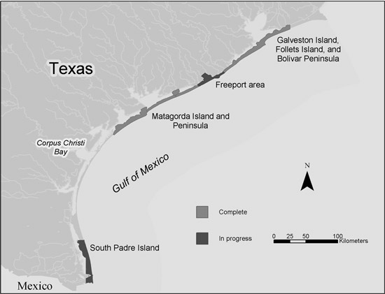 |
Figure 1. Status of barrier-system wetland mapping on the Texas Gulf Coast. |
METHODS
Since 2001 the Texas General Land Office (GLO) has flown aerial photography missions in areas of particular interest along the Texas coast. The photography program produces high-resolution (1-meter), color-infrared, digital aerial photographs that are georeferenced to a 1995–1996 digital orthophoto quadrangle (DOQ) base. BEG scientists use these photographs within the GIS environment to map wetland boundaries. Wetland unit codes are based on the National Wetlands Inventory (NWI) classification of Cowardin et al. (1979).
Bay and delta-margin mapping was conducted in a like manner using the 1995–1996 DOQ base. The bay and delta-margin units are a modification of those found in the Environmental Geologic Atlas of Texas (Fisher et al., 1972). Marsh delineation was aided through consultation of wetland mapping conducted by White et al. (1986) in the Submerged Lands of Texas series.
Wetland, bay, and delta-margin mapping were merged into a seamless data set and assigned codes on the basis of newly-devised mapping criteria. Map units that exhibit similar geoenvironmental characteristics, which are based on location or physical properties, were assigned a cross-classification “geoenvironmental” code.
Surface faulting was mapped by White and Morton (1997) in a paper examining wetland losses related to fault movement. The fault data were gathered from existing GIS data sets contained within the Coastal Hazards Atlas of Texas—Volume 1 (Gibeaut et al., 2000).
CONCLUSION
The proposed “Geoenvironmental Map” series will utilize existing barrier-system wetland and habitat mapping in conjunction with generalized geologic mapping to produce a multipurpose coastal-map series. Digitally based, the series will adapt to incorporate the best and most timely data sets available. The GIS-based map is seamless not only in spatial extent but in data content as well. Highly detailed wetland information, where available, will be retained within the database design. This aspect of the database provides additional information not found in traditional coastal-environmental maps. The BEG Coastal Studies Group owns and operates a LIDAR system that is used in various shoreline studies. Shoreline position and geomorphic features such as washover channels, obtained from LIDAR, will enhance the information content of future versions of the geoenvironmental map. With some regional modifications, the geoenvironmental map model can be applied to any coastal region.
ACKNOWLEDGMENTS
Wetlands mapping is funded through grants provided by the National Oceanic and Atmospheric Administration and the Coastal Coordination Council, administered by the Texas General Land Office. The STATEMAP component of the National Cooperative Geologic Mapping Program, administered by the U.S. Geological Survey, also provided funding for this study.
REFERENCES
Cowardin, L.M., Carter, V., Golet, F.C., and LaRoe, E.T., 1979, Classification of wetlands and deepwater habitats of the United States: U.S. Department of Interior, Fish and Wildlife Service, Washington, D.C., USA, 131 p.
Fisher, W.L., McGowen, J.H., Brown, L.F., and Groat, C.G., 1972, Environmental geologic atlas of the Texas Coastal Zone—Galveston–Houston area: The University of Texas at Austin, Bureau of Economic Geology, 91 p.
Gibeaut, J.C., Tremblay, T.A., and White, W.A., 2000, Coastal hazards atlas of Texas: a tool for hurricane preparedness and coastal management—volume 1, the southeast coast: The University of Texas at Austin, Bureau of Economic Geology, final report prepared for the Texas Coastal Coordination Council, pursuant to National Oceanic and Atmospheric Administration Award No. NA770Z0202, 69 p., accessed at http://www.beg.utexas.edu/coastal/hazard_atlas1.htm.
White, W.A., Calnan, T.R., Morton, R.A., Kimble, R.S., Littleton, T.G., McGowen, J.H., Nance, H.S., and Schmedes, K.E., 1986, Submerged lands of Texas, Brownsville–Harlingen area: sediments, geochemistry, benthic macroinvertebrates, and associated wetlands: The University of Texas at Austin, Bureau of Economic Geology Special Publication, 138 p.
White, W.A., and Morton, R.A., 1997, Wetland losses related to fault movement and hydrocarbon production, southeastern Texas coast: Journal of Coastal Research, v. 13, no. 4, p. 1305–1320.