|
|
|
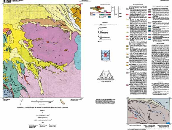
The Hemet 7.5' quadrangle is located near the eastern edge of the Perris block of the Peninsular Ranges batholith. The northeastern corner of the quadrangle extends across the San Jacinto Fault Zone onto the edge of the San Jacinto Mountains block. The Perris block is a relatively stable area located between the Elsinore Fault Zone on the west and the San Jacinto Fault Zone on the east. Both of the fault zones are active; the San Jacinto being the seismically most active in southern California. The fault zone is obscured by very young alluvial deposits. The concealed location of the San Jacinto Fault Zone shown on this quadrangle is after Sharp, 1967. The geology of the quadrangle is dominated by Cretaceous tonalite formerly included in the Coahuila Valley pluton of Sharp (1967). The northern part of Sharp's Coahuila Valley pluton is separated out as the Hemet pluton. Tonalite of the Hemet pluton is more heterogeneous than the tonalite of the Coahuila Valley pluton and has a different sturctural pattern. The Coahuila Valley pluton consists of relatively homogeneous hornblende-biotite tonalite, commonly with readily visible large euhedral honey-colored sphene crystals. Only the tip of the adjacent Tucalota Valley pluton, another large tonalite pluton, extends into the quadrangle. Tonalite of the Tucalota Valley pluton is very similar to the tonalite of the Coahuila Valley pluton except it generally lacks readily visible sphene. In the western part of the quadrangle a variety of amphibolite grade metasedimentary rocks are informally referred to as the rocks of Menifee Valley; named for exposures around Menifee Valley west of the Hemet quadrangle. In the southwestern corner of the quadrangle a mixture of schist and gneiss marks a suture that separated low metamorphic grade metasedimentary rocks to the west from high metamorphic grade rocks to the east. The age of these rocks is interpreted to be Triassic and the age of the suturing is about 100 Ma, essentially the same age as the adjacent Coahuila Valley pluton. Rocks within the suture zone consist of a mixture of lithologies from both sides of the suture. Gneiss, schist, and anatectic gneiss are the predominate lithologies within the rocks on the east side of the suture. Lesser amounts of metalithic greywacke and lenticular masses of black amphibolite are subordinate rock types. Biotite, biotite-sillimanite and lesser amounts of garnet-biotite-sillimanite schist and metaquartzite-metalithic greywacke lithologies occur west of the suture. Pleistocene continental beds, termed the Bautista beds occur east of the San Jacinto Fault Zone in the northeast corner of the quadrangle. Most of the Bautista beds were derived from the San Jacinto pluton that is located just to the east of the sedimentary rocks. Along the northern part of the quadrangle is the southern part of a large Holocene-late Pleistocene fan emanating from Baustista Canyon. Sediments in the Bautista fan are characterized by their content of detritus derived from amphibolite grade metasedimentary rocks located in the Bautista Canyon drainage. Between the Holocene-late Pleistocene Bautista fan and the Santa Rosa Hills is the remnant of a much older Bautista Canyon alluvial fan. A pronounced Holocene-late Pleistocene channel was developed along the south fringe of the very old alluvial fan and the Santa Rosa Hill. A now dissected late to middle Pleistocene alluvial complex was produced by the coalesced fans of Goodhart, St. Johns, and Avery canyons, and Cactus Valley. Pleistocene continental beds, termed the Bautista beds occur east of the San Jacinto Fault Zone in the northeast corner of the quadrangle. Most of the Bautista beds were derived from the San Jacinto pluton that is located just to the east of the sedimentary rocks. Along the northern part of the quadrangle is the southern part of a large Holocene-late Pleistocene fan emanating from Baustista Canyon. Sediments in the Bautista fan are characterized by their content of detritus derived from amphibolite grade metasedimentary rocks located in the Bautista Canyon drainage. Between the Holocene-late Pleistocene Bautista fan and the Santa Rosa Hills is the remnant of a much older Bautista Canyon alluvial fan. A pronounced Holocene-late Pleistocene channel was developed along the south fringe of the very old alluvial fan and the Santa Rosa Hill. A now dissected late to middle Pleistocene alluvial complex was produced by the coalesced fans of Goodhart, St. Johns, and Avery canyons, and Cactus Valley. |
Download this map as a 44x36-inch PDF document. This file is used for viewing and plotting the geologic map at full scale, correlation of map units and description of map units. (hmt1.1_map.pdf; 3.5 MB)
Download the readme file for this report as a text document (hmt1.1_readme.txt; 8 kB)
Download the metadata file for this report as a text document (hmt1.1_met.txt; 28 kB)
Download this map as a zipped .ps (PostScript) document. This file is used for plotting the geologic map at full scale, correlation of map units and description of map units. (hmt1.1_map.zip; 8.9 MB compressed; 19.9 MB uncompressed)
Download the digital-data plot package as a zip file (hmt.zip; 2.3 MB compresed; 3.8 MB uncompressed)
Download the map symbols as a zip document. Files in the plot package have been prepared to produce optimum plots using the shade, line, and marker sets; these symbol sets and supporting fonts are included in this file (symbols.zip; 183 kB compressed; 1.3 MB uncompressed).
For questions about the content of this report, contact Doug Morton.
| Help
| PDF help
| Publications main page | Open-File
Reports for 2005 |