
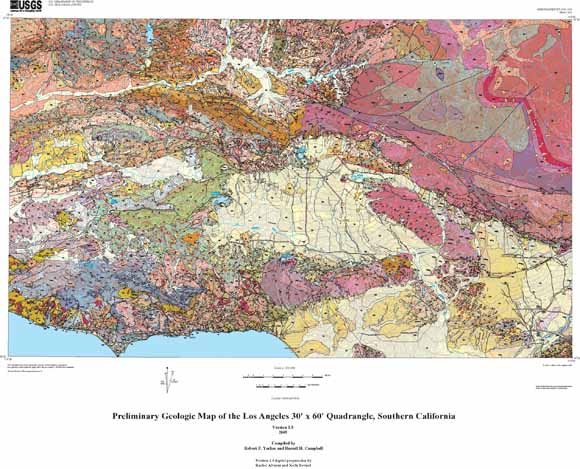
The Los Angeles 30' x 60' quadrangle covers approximately 5,000 km2 including much of the densely populated urban and suburban areas of the southern California megalopolis. The quadrangle is about 90 km east-west and about 55 km north-south, extending from Fillmore and Thousand Oaks in the west to Vincent in the northeast and Montebello in the southeast. It covers the urban San Gabriel Valley and San Gabriel Mountain foothill communities from Monrovia to Pasadena, as well as Glendale, downtown Los Angeles, Hollywood, Santa Monica, Malibu, and all the communities in the San Fernando Valley, Simi Valley, and the upper Santa Clara River Valley. Population of these urban and suburban areas, as listed in the 2000 Census, totals approximately 5.6 million, and property value is estimated to total hundreds of billions of dollars. The quadrangle also includes large areas of wilderness in the Angeles and Los Padres National Forests, in the Santa Monica Mountains National Recreation Area, and the Sespe Condor Sanctuary. The relief in the quadrangle ranges from about a hundred meters sub sea (in Santa Monica Bay) to more than 2,000 meters above sea level at Pacifico Mountain in the high San Gabriel Mountains. Residents and transient visitors are subject to potential hazards from earthquakes, debris flows and other landslides, floods, wildfires, subsidence from ground water and petroleum withdrawal, This geologic map is intended to illustrate the distribution of the rocks and surficial deposits of the area and their structural and stratigraphic relations to one another. It provides a regional geologic framework as an aid to better evaluations of the potential for hazard from active earth processes; however, it is not sufficiently detailed to serve as a basis for site-specific evaluations. |
| File
Name |
File
Type and Description |
File
Size |
| | ||
| DATA FILES |
||
| Spatial Data Package for GIS users in ArcInfo export format | 15.3-MB file that opens into an 84.8-MB folder |
|
| FILES FOR VIEWING AND PLOTTING |
||
| A zipped Encapsulated Postscript file for viewing and plotting the geologic map at full scale. The plot is approximately 44 x 36 inches in size | 23.7-MB file that opens into a 54.2 MB file |
|
| A Portable Document Format (PDF) file for viewing and plotting the geologic map at full scale. The plot is approximately 44 x 36 inches in size. | 28.1 MB |
|
| A zipped Encapsulated Postscript file for viewing and plotting the correlation of map units and abbreviated description of map units, approximately 42 x 36 inches in size. | 584-KB file that opens into a 1.3-MB file |
|
| A Portable Document Format (PDF) file for viewing and plotting the correlation of map units and abbreviated description of map units, approximately 42 x 36 inches in size. | 440 KB |
|
| A Portable Document Format (PDF) file for viewing and printing a pamphlet that accompanies the map. The pamphlet contains a geologic interpretation and the description of map units. | 1 MB |
|
| README |
||
| Database explanation pamphlet as a text file. This pamphlet will be of use to anyone interested in using the data and (or) the maps that are port of this product | 16 KB |
|
| METADATA |
||
| Federal Geographic Data Committee (FGDC) compliant metadata file derived from the digital database. | 64 KB |
|
| SYMBOLS |
||
| Symbol sets used in plotting geologic map. | 184-KB file that opens into a 1.3-MB folder |
|
For questions about the content of this report, contact Robert Yerkes or Russ Campbell
| Help
| PDF help
| Publications main page | Open-File
Reports for 2005 |