
U.S. Geological Survey Open-File Report 2005-1046
2005 - Version 1.0
Available online only
Results of Coalbed Methane Drilling in Panola
County, Texas
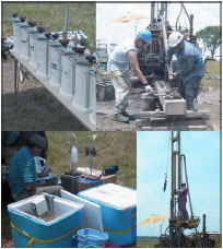 |
From June 13 to June 28, 1999, the U.S. Geological Survey (USGS), in cooperation with the Texas A&M University, drilled and continuously cored two coalbed methane test wells in the lower Wilcox Group (Paleocene) of Panola County, Texas. This report presents data obtained from the drilling and analytical program. The rock core obtained from this drilling project is in storage at the Texas A&M University Department of Geology and Geophysics. The purpose of this report is to release the raw data obtained from these two test wells. A number of preliminary interpretive reports were generated from this data. This report consists of: detailed rock core descriptions and selected core photographs from both wells; detailed laboratory descriptions of the coal and associated rock; plots of the geophysical logs (natural gamma, caliper, gamma-gamma density, and resistivity) from both wells; coal physical and geochemical data (proximate, ultimate, forms of sulfur, ash fusion temperatures, free swelling index, apparent specific gravity, and trace element data) for both wells; coal petrographic results including coal maceral | |
| composition, and vitrinite reflectance data; palynological data; dinocyst data; coal gas desorption results for samples from USGS–PA–2 (no gas was measured from samples obtained from USGS–PA–1); methane and carbon dioxide sorption data from selected samples from USGS–PA–2; Langmuir models for coal sorption of various mixtures of methane and carbon dioxide; coal gas molecular and isotopic data for a mixture of coal gas and canister headspace gas (air); Railroad Commission of Texas Coal Exploration Registration application and approval letters with detailed location maps; and digital files for geophysical logs and spread sheets. | ||
View a PDF file of this report [5.4 MB]
Data files are linked from the PDF file. If your browser does not fully support
the links, download the PDF file
to your desktop and view with Adobe Reader. Data files may also be downloaded
separately as a package
[25.5-MB .zip file] or browsed individually online
[photos | raw_data].
U.S. Department of the Interior, U.S. Geological Survey
URL: http://pubsdata.usgs.gov/pubs/of/2005/1046/index.html
For more information, contact Peter Warwick
Maintained by Eastern Publications Group
Last modified: 21:11:33 Sat 12 Jan 2013
Privacy statement | General disclaimer | Accessibility