![]()
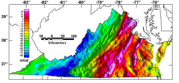
Virginia Complete Bouguer Gravity Anomaly Map
![]()
Bouguer gravity anomaly map (East illumination). Click on map to view larger image.

![]()
Station Index Map
![]()
Map showing distribution of gravity stations. Click on map to view larger image.
The complete-Bouguer gravity anomaly grid was compiled using data from 29,488 gravity stations from 65 separate sources in the state of Virginia. These data were extracted from the Gravity 1999 edition CD-ROM issued by the National Geophysical Data Center (Dater and others, 1999). Of the 29,488 gravity stations within the state of Virginia, approximately 18,200 were provided by the Virginia Division of Mineral Resources (VDMR). A previous statewide compilation was published by Johnson (1977).
Observed gravity relative to the IGSN-71 datum were reduced to the Bouguer anomaly using the 1967 gravity formula (Cordell and others, 1982) and a reduction density of 2.67 g/cm3. Outer-zone terrain corrections for 0.895 km (Hammer zone G) to 166.7 km from each station were computed using the computer algorithm of Godson and Plouff (1988). A digital elevation model with a 15 arc-second sample interval (digitized from USGS 1:250,000 scale topographic maps) was used closest to the station. No inner-zone terrain corrections (Hammer zones A-F) nor hand terrain corrections were made for the data in this report. The data were converted to a 2-km grid using minimum curvature techniques (Webring, 1981) and are displayed with an illumination from the east. The gravity data are available as an ASCII file or as a comma separated value (.csv) file for station data or as a grid.
The grids for this map in various formats are available from the data directory as vagrav.***

USGS Links || Eastern Minerals Team || Geologic Discipline || USGS Home Page