The National Park of American Samoa
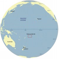 |
| Figure 1. Location of Samoa Islands in the South Pacific Ocean. Click on figure for larger image. |
The Samoan Archipelago consists of 14 volcanic islands (not all are inhabited) in the South Pacific Ocean (Figure 1). These islands are divided into the US Territory of American Samoa (Figure 2) and the independent country of Samoa. American Samoa contains the youngest volcanoes in the hot spot island chain with Tutuila being the oldest island in American Samoa. Presently, a new volcano, Vailulu'u (still 600 meters below the sea surface), is forming 45 km (28 miles) to the east of Ta'u, the youngest subaerial volcano in the Samoan chain (Hart and others, 2000) (Figure 2). The rocky, irregular coastline of American Samoa reflects the volcanic origin of these islands.
The National Park of American Samoa is separated into 3 main units on four islands. The four islands on which the park resides are: Tutuila (the largest and most populous of American Samoa), Ofu, Olosega, and Ta'u. Rose and Swain atolls are also within the US Territory of American Samoa, but there are no National Parklands on these islands.
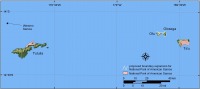 |
| Figure 2. Location of National Park of American Samoa. Click on figure for larger image. |
The park boundary on Tutuila lies along the northeast coast and largely consists of steep volcanic cliffs and headlands with small embayments containing carbonate beaches, alluvium, and wetlands (Richmond, 1995). Most of the fringing coral reefs and carbonate beaches are on Ofu and Olosega. Ta'u, like Tutuila, has areas of fringing coral reef, but the park coastline is primarily rocky cliff. Coral reefs in American Samoa are vulnerable to not only expected sea-level rise acceleration, but also storm damage, increased water temperatures, coral diseases, and land runoff and sedimentation. Because coral reef systems need light to grow, sea-level rise will likely result in death to ecosystems at the depth limit of light penetration (Hoegh-Guldberg, 1999). Some scientists would argue that sea-level rise alone could result in increased coral growth by providing more 'headroom' for ecosystems that have reached their limit of vertical growth. Although this could be a scenario, sea-level rise is likely to be accompanied by increased water temperatures and changes in salinity, which could further damage or stress coral ecosystems. Further, slow growing corals may not be able to keep pace with potential increases in the rate of sea-level rise (Hoegh-Guldberg 1999; Graus, 1998).
Other natural hazards that can impact coastal evolution in American Samoa include tropical cyclones, tsunamis, and landslides, but they are not directly addressed in the methodology of this report because their occurrence is episodic and the coastal impacts are difficult to predict.
American Samoa supports a diverse ecosystem that National Park of American Samoa is trying to preserve. In addition to the vast natural resources along this coast (Craig, 2002), there are also 3,000 years of Samoan cultural and archaeological resources within the park. For more information on park resources please see the National Park of American Samoa Web page: http://www.nps.gov/npsa.

 [an error occurred while processing this directive]