The Channel Islands National Park
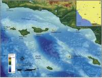 |
| Figure 1. Location of Channel Islands National Park, California. Click on figure for larger image. |
Channel Islands National Park lies off the coast of Southern California (Figure 1). Congress established Channel Islands National Park in 1980 in recognition of their vast natural and cultural resources. The Channel Islands National Marine Sanctuary was also established in 1980 to help preserve the marine ecosystem surrounding the northern Channel Islands.
The northern Channel Islands of Anacapa, Santa Cruz, Santa Rosa, and San Miguel make up a seaward continuation of the Santa Monica Mountains (Seeber and Sorlien, 2000). The islands were uplifted by faulting and folding and are composed of both volcanic (all of Anacapa) and sedimentary units (most of San Miguel) (Shaw and Suppe, 1994). During the last glacial maximum when sea level was 90 meters (300 feet) lower than present the northern islands were subaerially exposed as one large island called Santarosae (Vedder and Howell, 1980; Johnson, 1983; Porcasi and others, 1999). The southernmost of the Channel Islands, Santa Barbara, composed of volcanic rocks, lies 65 km (40 miles) to the southeast of Anacapa and was not part of Santarosae. For more information on geology and the individual islands see: http://www2.nature.nps.gov/geology/parks/chis/.
The Channel Islands contain rookeries for numerous sea bird colonies, six different species of pinnipeds, and over 100 species of organisms that are only found within the Channel Islands (for more information on natural resources within Channel Islands NP see: http://www.nps.gov/chis/rm/Index.htm). Cultural resources within the park date back as far as 10,000 years and include submerged resources such as shipwrecks.
This report addresses the antecedent geology and processes that continually drive coastal evolution over time-scales that sea-level rise will be relevant (the next 50 - 100 years). However, in addition to expected accelerated sea-level rise, the Channel Islands are subject to other geologic hazards that operate on shorter time-scales and can result in immediate and major coastal change. These hazards include earthquakes, landslides, and tsunamis, are they are not directly addressed in the methodology of this report.