The Golden Gate National Recreation Area
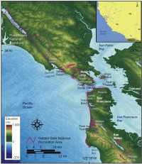 |
| Figure 1. Location of GGNRA, along the San Francisco Bay Region, California. Click on figure for larger image. |
The sandy and cliffed coast of GGNRA lies along the Northern Coast of California (Figure 1). Stretching from Tomales Bay north of San Francisco to San Mateo County to the south, GGNRA is one of the largest urban parks in the world. Further, the geology of GGNRA and the San Francisco Bay Area is among the most complex and active geologic settings in the world (for more information on the geology of the San Francisco Bay region see: http://wrgis.wr.usgs.gov/wgmt/sfbay/index.html). The reason for the Bay region's geologic complexity is that it lies along the boundary of two major tectonic plates: the North American Plate and the Pacific Plate. Rocks and sediments along the park coast reflect the dynamic nature of the plate boundary and include cherts, pillow basalts, mélanges, volcanic rocks and ash, ocean floor sediments, and sediments that are presently being deposited as dunes, alluvium, and stream deposits (Chin and Graymer, 2001). These large tectonic plates slide past one another at an average rate of about 2 inches per year. However, movement along the plate boundary can occur in catastrophic bursts, such as in 1906 when a magnitude 7.7 earthquake (Waldo and others, 1993) shook San Francisco and moved the Pacific Plate 20 feet to the northwest along the San Andreas Fault. Other geologic hazards that can result in immediate and major coastal change within the San Francisco Bay region include landslides and tsunamis, but they are not directly addressed in the methodology of this report because their occurrence is episodic and their coastal impacts are difficult to predict.
GGNRA was established in 1972, and NPS is preserving the vast natural, historical, and cultural resources within the urban park. Natural resources include over 1200 plant and animal species that exist in 19 distinct ecosystems. Cultural resources include archaeological sites, historic structures, and military forts (for more information on park resources see: http://www.nps.gov/goga/).