In 2001, a cooperative monitoring effort between the U.S. Geological
Survey (USGS), the Burlington Northern Santa Fe Railway (BNSF), BNSF's
geotechnical consultant, Shannon and Wilson, Inc., and the Washington
Department of Transportation was begun to determine whether near-real-time
monitoring of rainfall and shallow subsurface hydrologic conditions could
be used to anticipate landslide activity on the bluffs. Monitoring currently
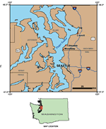
occurs at two sites-one near Edmonds, Washington, and the other near
Everett, Washington. During initial planning, the USGS proposed to evaluate
the monitoring results at the end of 3 years. This report summarizes
site conditions, methods, system reliability, data, and scientific results,
and identifies possible future directions for development of monitoring
and early warning of impending landslide activity.
Version 1.0
|
| Posted March 2005 |
| Part or all of this report is presented in Portable Document Format. The latest version of Adobe Acrobat Reader or similar software is required to view it. If you wish to download the latest version of Acrobat Reader free of charge, click here.
|
|
