Topographic Map of Quadrangle 3164, Lashkargah (605)
and Kandahar (606) Quadrangles, Afghanistan
Compiled by Robert G. Bohannon
Prepared in cooperation with the Afghan Geological Survey
and the Afghanistan Geodesy and Cartography Head Office under the auspices
of the U.S. Agency for International Development and the U.S. Trade and
Development Agency
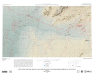
This map was produced from several larger digital
datasets. Topography was derived from Shuttle Radar Topography Mission
(SRTM) 85-meter digital data. Gaps in the original dataset were filled
with data digitized from contours on 1:200,000-scale Soviet General
Staff Sheets (1978–1997). Contours were generated by cubic convolution
averaged over four pixels using TNTmips1 surface-modeling
capabilities. Minor artifacts resulting from the auto-contouring
technique are present. Streams were auto-generated from the SRTM
data in TNTmips as flow paths. Flow paths were limited in number
by their Horton value on a quadrangle-by-quadrangle basis. Peak elevations
were averaged over an area measuring 85 m by 85 m (represented by
one pixel), and they are slightly lower than the highest corresponding
point on the ground. Cultural data were extracted from files downloaded
from the Afghanistan
Information Management Service (AIMS) Web site
(http://www.aims.org.af). The AIMS files were originally derived
from maps produced by the Afghanistan Geodesy and Cartography Head
Office (AGCHO). Because cultural features were not derived from the
SRTM base, they do not match it precisely. Province boundaries are
not exactly located.
This map is part of a series that includes a geologic map, a topographic
map, a Landsat natural-color-image map, and a Landsat false-color-image
map for the USGS/AGS (Afghan Geological Survey) quadrangles covering
Afghanistan. The maps for any given quadrangle have the same open-file
report (OFR) number but a different letter suffix, namely, -A, -B, -C, and -D
for the geologic, topographic, Landsat natural-color, and Landsat
false-color maps, respectively. The OFR numbers
range in sequence from 1092 to 1123. The present
map series is to be followed by a second series, in which the geology
is reinterpreted on the basis of analysis of remote-sensing data,
limited fieldwork, and library research. The second series is to
be produced by the USGS in cooperation with the AGS and AGCHO.
1Geospatial analysis software developed by MicroImages,
Inc., Lincoln, NE 68508-2010.
Recommended download procedures due to large
file size—right-click (PC) or control-click (Macintosh)
and save file to hard drive. Opening file from hard drive will
result in a faster load time.
For scientific questions or comments, please send inquiries to Robert
G. Bohannon (E-mail: bbohannon@usgs.gov).
For more information about USGS activities in Afghanistan, visit the USGS
Projects in Afghanistan Web site (http://gisdata.usgs.net/Website/Afghan/).
To view and print Portable Document Format (PDF) files you will need Adobe Reader software. Download the latest version of Adobe Reader, free of charge.