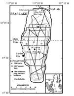
The Bear Lake Valley in northeastern Utah and adjacent Idaho is a half graben
containing a mesosaline-alkaline lake (Bear Lake). The lake is 32 km
long and 6–13 km wide with an area of 280 km2 at full capacity. Maximum depth is 63 m, with a mean depth of 28 m. The present
elevation of the lake is 1805 meters above sea level (masl), but this
level has varied considerably through time. The natural watershed of
the lake is relatively small, with a basin-area:lake-area ratio of only
4.8:1. Historically, the Bear River did not flow into Bear Lake. A series
of canals, built from 1909 to 1918, now diverts the Bear River into Bear
Lake creating a reservoir to supply irrigation water downstream. This
increased the basin-area:lake-area ratio considerably to 29.5:1. The
mean annual surface hydrologic flux (including precipitation) to the
lake is 0.48 * 109 m3/yr, which is only about 6 percent of the lake volume (7.86 * 109 m3), giving an average residence time of about 16 years. The magnitude of ground
water influx is not known.
Kullenberg piston coring in 1996 and seismic profiling in 1997 and 2002 reveal
a layered sediment package with clear wedging reflectors and erosional
unconformities. The piston cores recovered highly resolved records with
excellent definition of geochemical-climate proxies and low-sedimentation
rates. They are only a maximum of 5 m in length but provide a 30,000-year
record, well beyond the last glacial maximum. Some unknown amount of
sediment was missing from the tops of the piston cores so surface sediments
(up to 50 cm) were collected with a gravity corer. The Holocene sediments
are carbonate-rich (predominantly aragonite), and the glacial-age sediments
consist of calcareous silty clays, probably indicating direct inflow
of Bear River into Bear Lake.
The seismic stratigraphy below the lake indicates that the principal structure
is a half graben, with a steep normal-fault margin on the east and a
ramp margin on the west. Seismic reflections diverge toward the master
fault, bounding eastward thickening sediment wedges. Secondary normal
faults west of the master fault were imaged beneath the lake, and many
of these faults show progressively increasing throw with depth and age.
Several faults cut the youngest sediments in the lake as well as the
modern lake floor. Although pinch-outs of sedimentary units are common
in relatively shallow water, no major erosional or depositional features
suggestive of shoreline processes were observed on seismic profiles in
water deeper than about 5 m.
Version 1.0
|
| Posted October 2005 |
|
Part or all of this report is presented in Excel and Portable Document Format.
The latest version of Adobe Acrobat Reader or similar software
is required to view it. If you wish to download the latest version
of Acrobat Reader free of charge, click here.
|
|
