Link to USGS home page Link to USGS home page
Coastal and Marine Geology Program
Coastal & Marine Geology Program > Coastal Classification Mapping Project > Open File Report 2005-1151

Coastal Classification Atlas

Alabama-Mississippi Coastal Classification Maps - Perdido Pass to Cat Island

USGS Open File Report 2005-1151

Robert A. Morton, Russell L. Peterson

Report Home Maps Overview Mapping Methods Coastal Classifications Geologic Setting Coastal Processes Coastal Vulnerability Classification Summary References
Introduction || City: Cat Island | Ship Island | Dog Keys Pass | Horn Island West | Horn Island East | Petit Bois Island | Petit Bois Pass | Fort Morgan Northwest | Heron Bay/Fort Morgan Northwest | Little Dauphin Island/Fort Morgan | Fort Morgan | Little Point Clear/St. Andrews Bay | Bon Secour Bay/Pine Beach | Gulf Shores/Gulf Shores OE South | Orange Beach
Area: Northwest | Northeast

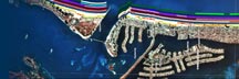
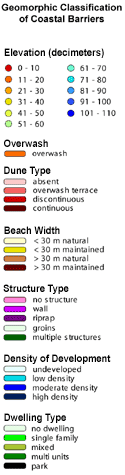
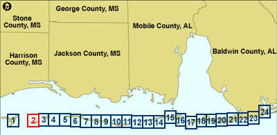
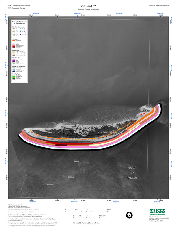
Ship Island NW Coastal Classification Map

Map showing the coastal classifications along the Alabama-Mississippi shoreline. The top item in the legend refers to the most landward data line. The last item in the legend refers to the most seaward data line. Click on the links below to download and view larger versions of the map. At the bottom of the page is a clickable index map that will take you to the other maps.

8 1/2" X 11" (45 KB JPEG)
14" X 18" (117 KB JPEG)
21" X 27" (256 KB JPEG)
  Printable PDF version (13.1 MB PDF)
Can't see the PDF version?
Get Adobe Acrobat® Reader
 
Coastal classification map for Ship Island NW.
Coastal Classification Map for Ship Island NW.
map legend
Map legend.
Index map with Ship Island NW highlighted.
1. Cat Island NW
2. Ship Island NW
3. Ship Island NE
4. Dog Keys Pass NW
5. Dog Keys Pass NE
6. Horn Island West NW
7. Horn Island West NE
8. Horn Island East NW
9. Horn Island East NE
10. Petit Bois Island NW
11. Petit Bois Island NE
12. Petit Bois Pass NW
13. Petit Bois Pass NE
14. Fort Morgan Northwest NW
15. Heron Bay SE/Fort Morgan Northwest NE
16. Little Dauphin Island SW/Fort Morgan NW
17. Fort Morgan NE
18. Little Point Clear SW/St. Andrews Bay NW
19. Little Point Clear SE/St. Andrews Bay NE
20. Bon Secour Bay SW/Pine Beach NW
21. Bon Secour Bay SE/Pine Beach NE
22. Gulf Shores SW/Gulf Shores OE South NW
23. Gulf Shores SE/Gulf Shores OE South NE
24. Orange Beach SW
Clickable Index Map. Use the index map above to navigate to the different coastal areas.
 

Orange Beach SWGulf Shores SE/Gulf Shores OE South NEGulf Shores SW/Gulf Shores OE South NWBon Secour Bay SE/Pine Beach NEBon Secour Bay SW/Pine Beach NWLittle Point Clear SE/St. Andrews Bay NELittle Point Clear SW/St. Andrews Bay NWFort Morgan NELittle Dauphin Island SW/Fort Morgan NWHeron Bay SE/Fort Morgan Northwest NEFort Morgan Northwest NWPetit Pois Pass NEPetit Pois Pass NWPetit Pois Island NEPetit Pois Island NWHorn Island East NEHorn Island East NWHorn Island West NEHorn Island West NWDog Keys Pass NEDog Keys Pass NWShip Island NECat Island NW

Coastal & Marine Geology Program > Coastal Classification Mapping Project > Open File Report 2005-1151


[an error occurred while processing this directive]