Open-File Report 2005-1162
USGS Open-File Report 2005-1162, Sidescan-Sonar Imagery and Surficial Geologic Interpretation of the Sea Floor off Bridgeport, Connecticut
Title Page | Introduction | Geologic Setting | Data/Processing | Bathymetry | Sidescan | Catalog | Figures | References| Contacts
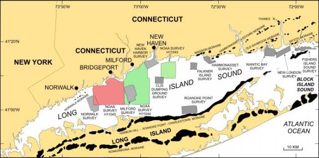 | ||
Figure 1. Map showing location of the Bridgeport, Connecticut, study area (red polygon). Also shown are the sites of major onshore and offshore moraines and other interpreted sidescan-sonar surveys in Long Island Sound: NOAA Survey H11044 - McMullen and others (2005); NOAA Survey H11043 -- Poppe and others (2004);Norwalk -- Twichell and others (1997); Milford -- Twichell and others (1998); New Haven Harbor and CLIS -- Poppe and others (2001); Roanoke Point -- Poppe and others (1999a); Falkner Island -- Poppe and others (1999b); Hammonasset -- Poppe and others (1997); Niantic Bay -- Poppe and others (1998a); New London -- Poppe and others (1992), Moffett and others (1994), Zajac and others (2000, 2003); Fishers Island Sound -- Poppe and others (1998b). | ||

![]() U.S. Department of the Interior |
U.S. Geological Survey
U.S. Department of the Interior |
U.S. Geological Survey
URL: http://pubsdata.usgs.gov/pubs/of/2005/1162/html/fig1.html
Page Contact Information: GS Pubs Web Contact
Page Last Modified: Friday, 23-Aug-2024 13:30:02 EDT
