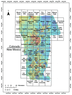
This report describes data collected from a high-resolution aeromagnetic survey
flown over the central San Luis basin during October, 2004, by PRJ, Inc.,
on contract to the U.S. Geological Survey (USGS). The survey extends
from just north of Alamosa, Colorado, southward to just northwest of
Taos, New Mexico. It covers large parts of the San Luis Valley in Alamosa,
Conejos, Costilla, and Rio Grande Counties, southern Colorado, and the
Taos Plateau in Taos County, northern New Mexico. The survey was designed
to complement two surveys previously acquired along the eastern borders
of the San Luis Basin over the vicinities of Taos, New Mexico (Bankey
and others, 2004a) and Blanca, Colorado (Bankey and others, 2004b). Our
overall objective in conducting these surveys is to improve knowledge
of the subsurface geologic framework in order to understand ground-water
systems in populated alluvial basins along the Rio Grande. These USGS efforts are conducted in collaboration with other federal, state, and local governmental
entities where possible.
Version 1.0
|
| Posted July 2005 |
|
Part or all of this report is presented in Portable Document Format. The latest
version of Adobe Acrobat Reader or similar software is required
to view it. If you wish to download the latest version of Acrobat
Reader free of charge, click here.
|
|
