Nuclear weapons are integral to the defense of the United States. The U.S. Department
of Energy, as the steward of these devices, must continue to gauge the
efficacy of the individual weapons. This could be accomplished by occasional
testing at the Nevada Test Site (NTS) in Nevada, northwest of Las Vegas.
Yucca Flat Basin is one of the testing areas at the NTS. One issue of
concern is the nature of the somewhat poorly constrained pre-Tertiary
geology and its effects on ground-water flow in the area subsequent to
a nuclear test. Ground-water modelers would like to know more about the
hydrostratigraphy and geologic structure to support a hydrostratigraphic
framework model that is under development for the Yucca Flat Corrective
Action Unit (CAU).
During 2003, the U.S. Geological Survey (USGS) collected and processed Magnetotelluric
(MT) and Audio-magnetotelluric (AMT) data at the Nevada Test Site in
and near Yucca Flat to help characterize this pre-Tertiary geology. That
work will help to define the character, thickness, and lateral extent
of pre-Tertiary confining units. In particular, a major goal has been
to define the upper clastic confining unit (UCCU) in the Yucca Flat area.
Interpretation will include a three-dimensional (3-D) character analysis
and two-dimensional (2-D) resistivity model. The purpose of this report
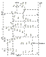
is to release the MT sounding data for Southern Yucca Flat, Profile 4,
as shown in Figure 1. No interpretation of the data is included here.
|
