Relative Coastal Change-Potential Assessment of Glacier Bay National Park and Preserve
USGS Open-File Report 2005-1247
 Relative Coastal Change-Potential Assessment of Glacier Bay National Park and Preserve USGS Open-File Report 2005-1247 |
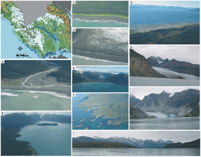
Figure 6. Photos of landforms within GBNPP. The figure in the upper left is indicating the approximate location of photos A - J. A) This is a high change-potential gravel beach shoreline north of Cape Fairweather. B) The sides of Lituya Bay were ranked as moderate change-potential because they are composed of alluvium and glacial deposits. C) A small section of coast between Lituya Bay and LaPerouse Glacier is rocky, and thus ranked as low change-potential. D) Laperouse is a tidewater glacier along the Gulf of Alaska coast, very high change-potential. E) An alluvium filled valley within Palma Bay is moderate change-potential while the high cliffs on either side are ranked as very low change-potential. F) The shoreline near Cape Spencer is ranked as low to very low change-potential based on the height of the cliffs. G) The Gustavus outwash plain was ranked as high change-potential because wave and tidal currents here rework the sediments along this area. H) Riggs glacier (very high change-potential) in Muir Inlet is bound on its north side by very low change-potential rock cliffs. I) McBride glacier is very high change-potential surrounded by moderate change-potential moraines and low change-potential cliffs. J) Moraines (moderate change-potential) near the entrance to Muir Inlet were deposited in the late 19th century as Muir Glacier retreated up the inlet some 35 km. A map with location names is provided by the National Park Service and can be viewed in digital format at: http://home.nps.gov/applications/parks/glba/ppMaps/ACF30C1.pdf. | ||
 |
||
