The Great Lakes National Lakeshores
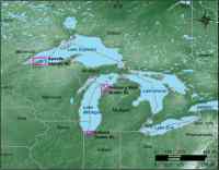 |
| Figure 2. Location of Great Lakes National Lakeshores: Sleeping Bear Dunes, MI; Indiana Dunes, IN; and Apostle Islands, WI. Click on figure for larger image. |
The Great Lakes enclose the largest single mass of fresh water in the world. The three National Lakeshores presented in this report, Apostle Islands, Indiana Dunes, and Sleeping Bear Dunes, represent over 400 km (250 miles) of Great Lakes shoreline (Figure 2). The modern shoreline of the Great Lakes is primarily the result of the Wisconsin glaciation and the subsequent deglaciation. The Laurentide ice sheet of the Wisconsin glaciation reached its maximum extent about 23,000 years BP and had disappeared completely by 8,000 years BP. Ice retreat landforms, such as moraines, and ancient lake-phase shorelines associated with crustal rebound, ice sheet margin, and drainage outlet, stipple the Great Lakes landscape; these features have been further modified during the Holocene by lake-level changes and wind and wave processes. The three National Lakeshores in this CPI report are described in more detail in the following paragraphs.
Apostle Island National Lakeshore
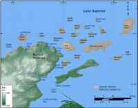 |
| Figure 3A. Detailed map of Apostle Islands National Lakeshore Click on figure for larger image. |
Apostle Island National Lakeshore lies along the southwestern shore of Lake Superior. The Apostle Island archipelago contains twenty-two islands, twenty-one of which lie within the boundary of Apostle Islands National Lakeshore. A 12-mile sand spit along the Bayfield Peninsula also lies within jurisdiction of the National Lakeshore (Figure 3A). The basement rock of the Apostle Islands is Precambrian sandstone, but the surficial geology is a diverse landscape of weathered sandstone cliffs and glacial till that have been reshaped by lake processes to produce abundant sand beaches and spits. Late Holocene shorelines of Lake Superior fluctuations were mapped within the Apostle Islands by Larsen and others (1999) and are visible within the park as well older, higher shorelines from glacial lakes (Teller and Thorleifson, 1983). There are six historic lighthouses within Apostle Islands National Lakeshore as well as cultural resources associated with Native Americans, voyageurs, quarrying, loggers, farmers, and fisherman. For more information on Apostle Islands National Lakeshore see: http://www2.nature.nps.gov/geology/parks/apis/
Indiana Dunes National Lakeshore
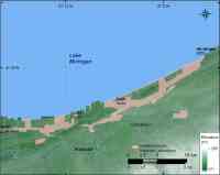 |
| Figure 3B. Detailed map of Indiana Dunes National Lakeshore. Click on figure for larger image. |
Indiana Dunes National Lakeshore spans 24 km (15 miles) of Lake Michigan shoreline between Michigan City and Gary, IN (Figure 3B). The beautiful beaches along this stretch of lakeshore are a significant recreational resource for the park and a diverse wildlife retreat situated in a large urban setting. Bedrock lies far beneath the surface and large moraines, beach ridges, and sand dunes preserve a record of the glacial history and subsequent lake-level changes of this area. Indiana Dunes NL at the southern end of Lake Michigan represents the largest strandplain of beach ridges in the Great Lakes with about 150 distinct ridges that have evolved over the past 6000 years (Thompson, 1992). In the past 2600 calendar years beach ridges have formed about every 30 years due to lake level changes and the rate of sediment supply to the area (Thompson and Baedke, 1995). Colman and others (2000) estimated that sediments are being deposited in the basin of southern Lake Michigan between 4 and 11 times faster than in the 5,000 years before human settlement, which would suggest a higher rate of erosion of the lakeshore due to lake-level change or changes in land use. Indiana Dunes National Lakeshore is home to one of the most diverse biological communities per unit area of any of the national parks. For more information on Indiana Dunes National Lakeshore see: http://www2.nature.nps.gov/geology/parks/indu/index.cfm
Sleeping Bear Dunes National Lakeshore
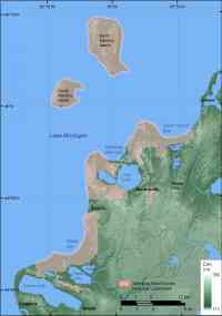 |
| Figure 3C. Detailed map of Sleeping Bear Dunes National Lakeshore. Click on figure for larger image. |
Sleeping Bear Dunes National Lakeshore encompasses 103 km (64 miles) of Lake Michigan shoreline including the Manitou Islands (Figure 3C). After the last ice sheet retreated from the region about 12,000 years ago, lake currents, waves, and winds began reshaping the glacial till that was deposited. Today, sand beaches, spits, and bars line the coast and attest to lake and wind processes. Similar to Indiana Dunes NL, Sleeping Bear Dunes NL has successive beach ridges that formed in glacial terrain embayments, such as the one at Platte Bay (Thompson, 1992). The beach-ridge stratigraphy in Indiana Dunes NL represents a more continuous record than Sleeping Bear Dunes because the rate of sediment supply to southern Lake Michigan is higher. Perched dunes and beach dunes, for which the park is well known, sit on top of high glacial bluffs or lie along the beach, and adjust to the prevailing winds from Lake Michigan. In 1995, a nearly 500-m (1600-feet) block of sediment slipped off the bluff near Sleeping Bear Point and into Lake Michigan. This was the third landslide to occur during the 20th century at Sleeping Bear Point. Jaffe and others (1998) believe that these landslides are triggered by an increase in pore pressure between sand grains in the bluff, brought on by snowmelt being trapped behind a frozen bluff face, weakening the bluff. Geophysical techniques revealed another source of potential bluff weakening related to a paleochannel that could act as a conduit for groundwater, reducing sediment strength and promoting slope failure (Barnhardt and others, 2004). In addition to the vast water and geologic resources within the park, Sleeping Bear Dunes provides a diverse habitat for many species; one example is the 160 different species of nesting birds. For more information on Sleeping Bear Dunes National Lakeshore see: http://www2.nature.nps.gov/geology/parks/slbe/index.cfm