|
|
|
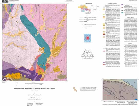
The Sage 7.5' quadrangle is located at the southern part of the Perris block of the Peninsular Ranges batholith, a relatively stable area located between the Elsinore and San Jacinto Fault Zones. The geology of the quadrangle is dominated by parts of two large tonalite plutons, the tonalite of the Coahuila Valley pluton of Sharp (1967), and the tonalite of the Tucalota Valley pluton. Most of the tonalite in both plutons is massive or very slightly foliated and contains scattered ellipsoidal mafic inclusions. In the northwestern corner of the quadrangle is an intimate mixture of schist, gneiss and heterogeneous granitic rocks. Some of the granitic rocks are white mica-bearing monzogranite. In most of the area the Tucalota Valley pluton is separated from the Coahuila Valley pluton by a broad septum of gneiss and schist. The metamorphic rocks consist of foliated biotite schist, biotite gneiss, and impure quartzite. Antatectic gneiss is common. Hornblende gabbro invaded by a variety of heterogeneous grantitic rocks occurs in the southern part of the quadrangle. The Temecula Arkose is mainly pale greenishyellow, medium- to coarse-grained, indurated sandstone. It includes thin discontinuous beds of tuffaceous sandstone, siltstone, and claystone, and some pebble and conglomerate beds having locally derived clasts. Kennedy (1977) assigned the unit a late Pliocene Blancan IV-V mammal age (2.2 to 2.8 Ma) based on vertebrate assemblages collected east of quadrangle. Assemblages include Nannippus, Hypolagus, Tetrameryx, Equus, and Odocoileus. Later work established the first occurrence of Tetrameryx as Irvingtonian I rather than late Blancan, placing the Temecula Arkose age nearer 1.9 Ma (late Pliocene) than 2.2 Ma. A microtine fauna from this unit in the Radec area, about five miles east of Santa Ana quadrangle, is considered to have an age of 4.6 Ma (Blancan I). Thickness of the Temecula Arkose ranges from 90 to over 550 m. A thin, narrow outcrop of vesicular basalt, the Miocene basalt of Temecula area, occurs in the southwest corner of the quadrangle. A large landslide, the Oak Mountain landslide consists of gabbro fragments largely resting on the Pliocene Temecula Arkose. Major drainages, such as Tucalota Creek, Lewis Valley, and Weber Valley, contain both dissected Pleistocene alluvial deposits and essentially undissected Holocene alluvial deposits. Some of the drainages, such as Glenoak Valley, contain mainly Holocene alluvial deposits. |
Download this map as a 45x36-inch PDF document. This file is used for viewing and plotting the geologic map at full scale, correlation of map units and description of map units. (sage1_map.pdf; 5.3 MB)
Download the readme file for this report as a text document (sage1_readme.txt; 8 KB)
Download the metadata file for this report as a text document (sage1_met.txt; 24 KB)
Download this map as a zipped .eps (encapsulated PostScript) document. This file is used for plotting the geologic map at full scale, correlation of map units and description of map units. (sage1_map.zip; 7.2 MB - opens to a 12.3-MB .eps file)
Download the digital-data plot package as a zip file (sage.zip; 2.4 MB - opens to a 3.7-MB folder)
Download the map symbols as a zip document. Files in the plot package have been prepared to produce optimum plots using the shade, line, and marker sets; these symbol sets and supporting fonts are included in this file (symbols.zip; 184 KB - opens to a 1.3-MB folder)).
For questions about the content of this report, contact Doug Morton.
| Help
| PDF help
| Publications main page | Open-File
Reports for 2005 |