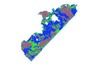
mlclass5- Nahant to Gloucester, Maximum Likelihood Bottom Classification | |
Data format: Raster Dataset - ESRI GRID File or table name: mlclass5 Coordinate system: Universal Transverse Mercator Theme keywords: U.S. Geological Survey, USGS, Coastal and Marine Geology Program, CMGP, Woods Hole Science Center, WHSC, Bathymetry, Seafloor, Marine Geology, Swath Bathymetry, Interferometric Sonar, ArcGIS Raster, field activity serial number RAFA03007, field activity serial number RAFA04002, Bottom Classification, Bottom Type, geoscientificInformation, elevation, imageryBaseMapsEarthCover |
|
Abstract:
These data are high-resolution maximum likelihood classification of the seafloor offshore of Massachusetts, from Nahant to Gloucester. Approximately 127 kmē of the inner shelf were mapped in the nearshore region between the 10m and 40-m isobath. |
Metadata elements shown with blue text are defined in the Federal Geographic Data Committee's (FGDC) Content Standard for Digital Geospatial Metadata (CSDGM). Elements shown with green text are defined in the ESRI Profile of the CSDGM. Elements shown with a green asterisk (*) will be automatically updated by ArcCatalog. ArcCatalog adds hints indicating which FGDC elements are mandatory; these are shown with gray text.
These data are high-resolution maximum likelihood classification of the seafloor offshore of Massachusetts, from Nahant to Gloucester. Approximately 127 kmē of the inner shelf were mapped in the nearshore region between the 10m and 40-m isobath.
The purpose of this data set is to calculate a generalized sea floor bottom type using multivariate statistics, and high resolution depth (bathymetry) and acoustic backscatter (sidescan sonar) data. These data were collected under a cooperative agreement with the Massachusetts Office of Coastal Zone Management (CZM) and the U.S. Geological Survey, Coastal and Marine Geology Program, Woods Hole Science Center. High resolution bathymetry, backscatter intensity, and seismic profile data were collected over 127 kmē area covering a portion of the South Essex Ocean Sanctuary to characterize the surface and subsurface of the seafloor for regional geologic framework investigations. geophysical data were collected during two different surveys. Survey RAFA03007 began Monday, 22 Sep 2003 (JD267) and ended on Tuesday, 14 Oct 2003 (JD287). RAFA04002 began 17 Apr 2004 (JD 108) and ended on 2 May 2004 (JD123).
ground condition
Data are not intended for navigational use. These data should not be used at resolutions for which they are not intended. Additional ground validation should be conducted to use these data for applications other than regional geologic framework studies at spatial scales finer that 1:60,000. Public domain data from the U.S. Government are freely redistributable with proper metadata and source attribution. Please recognize the U.S. Geological Survey (USGS) as the source of this information.
384 Woods Hole Rd.
Bottom classification was calculated using the ISOCluster and Maximum likelihood tools combined in a custom modelbuilder model. Rigorous error analysis of the ISOCluster function has not been conducted. These data are intended for regional geologic framework investigations and should not be used for applications at fine scales without additional ground validation
Iso Cluster model Number of Classes=5, Max_Iterations=20, min_class_size=20 sampling interval=10 Number of Selected Grids = 3 input grids 1) se_5mbath 2) slope_fm3 3) ss_mos_5m.tif output signature file = isoclus5.gsg
Maximum Likelihood classification model Geoprocessing History: Process: *Process name: MLClassify_2 *Date: 20050202 *Time: 221410 *Tool location: C:\Program Files\ArcGIS\ArcToolbox\Toolboxes\Spatial Analyst Tools.tbx\MLClassify *Command issued: MLClassify agg_5mb.tif;slopedeg_fm3;sebath_fm3 C:\MCZM\data\bath\grids\5m_bsssl.gsg C:\MCZM\data\bath\grids\mlclass_5all 0.0 EQUAL # #
Internal feature number.
ESRI
Bottom Type
USGS
Sand/Silt
USGS
Cobble/Boulders
USGS
Ledge
USGS
No Data
USGS
Multivariate bottom classification in ESRI GRID format. Data values represent bottom type classification
384 Woods Hole Rd.
Although this data set has been used by the U.S. Geological Survey (USGS), no warranty, expressed or implied, is made by the USGS as to the accuracy of the data and/or related materials. The act of distribution shall not constitute any such warranty, and no responsibility is assumed by the USGS in the use of these data or related materials. Any use of trade, product, or firm names is for descriptive purposes only and does not imply endorsement by the U.S. Government.
ESRI Raster GRID format
384 Woods Hole Rd.