
|
|
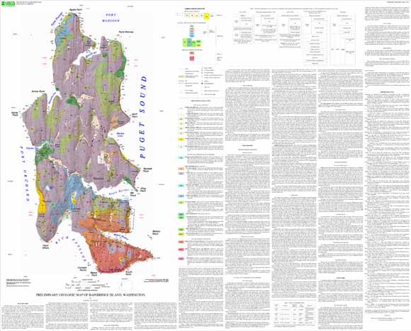
Bainbridge Island is in the center of the Puget Lowland, Washington, surrounded by the waters of Puget Sound. Winslow, the commercial center of the island, is a 35-minute ferry ride from Seattle. The island lies within the Suquamish and Bremerton East 7.5-minute quadrangles. This open-file report is an advance view of quadrangle-format mapping of these areas by the U.S. Geological Survey. This study of Bainbridge Island was undertaken in response to (1) recent awareness of the hazard posed by future earthquakes in the Seattle fault zone, at the south edge of the island, and the need to marshal geologic evidence for the rate and style of deformation; (2) increasing population on Bainbridge Island and consequent pressure on groundwater resources; (3) concern about landslide hazards; and (4) increased awareness of the role that the nearshore zone plays in supporting marine resources. Almost all post-glacial deposits, ice-contact deposits, most fault traces, and most bedding traces were mapped from detailed lidar topography. Vashon till and older strata were delineated on the basis of field observations, including traverses and numerous dug or augured holes. Subsurface observations extracted from a database compiled by GeoMapNW at the University of Washington (http://geomapnw.ess.washington.edu) were used to refine the distribution of till and older units. |
Download this report as a ~45" X 36" PDF document (2.6 MB)
Download the digital data package as a .zip compressed file (563 KB that opens into a 3-MB folder)
For questions about the content of this report, contact Ralph Haugerud.
| Help
| PDF help
| Publications main page | Open-File
Reports for 2005 |