
|
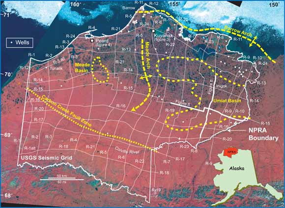
Location of regional seismic lines (white) and selected subsurface features (yellow) within the NPRA plotted on LANDSAT satellite image. Geologic features are after Kirschner and Rycerski (1988) who used the full suite of NPRA 2D seismic in their determination. (from figure 1). |
|
Interpretation of reprocessed data from a regional grid of 25 public-domain 2-D seismic profiles in the National Petroleum Reserve in Alaska has enabled an analysis of subsurface geologic relations throughout that region. Notable results include interpretations of the geometry of the Mississippian Umiat and Meade basins, and depositional patterns in the thick succession of younger strata that were influenced by major structural features such as the Barrow arch and the Brooks Range. Pre-Mississippian low-grade metamorphic rocks and subordinate granites of the Franklinian sequence are the basement rocks of the region. The top of the Franklinian is imaged as one of the highest amplitude, most continuous reflections. The sedimentary succession includes (1) the Mississippian to Triassic Ellesmerian sequence (consisting of the Endicott, Lisburne and Sadlerochit groups, and the Shublik Formation and Sag River Sandstone; (2) the Beaufortian sequence, comprising the Jurassic to Lower Cretaceous Kingak Shale and the overlying Lower Cretaceous pebble shale unit; and (3) the Cretaceous to Paleocene Brookian sequence, which includes the Hue Shale and the Torok, Nanushuk, Seabee, Tuluvak, Schrader Bluff, and Prince Creek formations. Stratigraphic horizons that were mapped seismically include the tops of the Franklinian basement, the Endicott, Lisburne, and Sadlerochit groups, the Shublik Formation, the Sag River Sandstone, the Lower Cretaceous unconformity (LCU), and the gamma-ray zone of the Hue Shale. Distinguishing criteria were established for the seismic-reflection characteristics for each of these horizons, and the results were used in the correlation of units across the basins and onto the bordering margins. |
Download this report as a 25-page PDF file (31.5 MB)
Go to the Plates folder to browse the 25 interpreted-seismic-section files (363 MB total)
For questions about the content of this report, contact Christopher Potter
|
Help |
PDF help |
Publications main page |
Open-File
Reports for 2005 |
This report is available only on the Web