Abstract
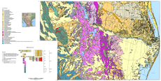
The geologic map covers the southernmost part of Texas (parts of Jim Hogg, Brooks, Starr, Hidalgo, Zapata, Willacy, Kenedy, and Cameron Counties), and parts of Nuevo Leon and Tamaulipas, Mexico. Geologic units become younger from west to east across the map area. The oldest rocks are in the western part of the map area in the states of Nuevo Leon and Tamaulipas, Mexico, and include mostly Cretaceous and Jurassic marine limestone, sandstone, shale, and evaporite units exposed in a series of north to northwest-trending ranges. These rocks are highly folded and are part of the Sabinas foldbelt (Ewing, 1991), a compressional terrain which formed during the Laramide (Cretaceous to Paleocene) due to complex interactions related to subduction of the Pacific plate beneath North America. The Mesozoic rocks were intruded by Miocene and Oligocene igneous rocks. The central and eastern portions of the map cover the Gulf Coastal Plain province extending across southern Texas and Tamalupias and Nuevo Leon, Mexico. Rocks in central part of the map area are Tertiary units consisting mostly of sandstone, shale, and claystone units deposited in mixed marine and continental environments. These Paleocene to Pliocene rocks dip east and formed as a result of rapid deposition and progradation of sediments across the continental margin into the Gulf of Mexico. The rapid infilling resulted in the development of syndepositional growth faults which formed episodically from Paleocene to the Pliocene. The growth faults (Ewing, 1986) are concealed beneath Pliocene and Quaternary deposits and form a structurally complex Gulf Coast Tertiary basin. Tertiary bedrock units are important because they contain oil and gas resources in south Texas and in Tamaulipas, Mexico (Burgos basin), and uranium deposits in the South Texas Uranium District (Galloway and others, 1979; Eargle and others, 1971; Henry and Kapadia, 1980). In addition, some of these rocks also are aquifers for ground water in the region. Rocks bordering the Gulf of Mexico are the youngest units in the map area consisting mostly of Quaternary and modern coastal deposits in deltaic, tidal flat, beach, barrier island, lagoonal, esturary, and dune environments (Brown and others, 1980).
|
