U.S. Geological Survey Open-File Report 2005-1428
Digital Mapping Techniques '05—Workshop Proceedings
The U.S. Fish and Wildlife Service (FWS) is a federal agency whose mission, working with others, is to conserve fish and wildlife and their habitats for the continuing benefit of the American people. This mission is partially fulfilled through the establishment and maintenance of wildlife refuges. Under the management of fish and wildlife professionals, the National Wildlife Refuge System has become the worlds premier network of wildlife habitats. The FWS is making use of modern cartographic methods and implementing Geographic Information Systems to more effectively manage the lands and resources entrusted to them.
One hundred years in the making, the National Wildlife Refuge System is a network of habitats that benefit wildlife, provide unparalleled outdoor experiences for all Americans, and protect a healthy environment. Since President Theodore Roosevelt designated Florida's Pelican Island as the first wildlife refuge in 1903, these lands have grown to encompass approximately 100 million acres within more than 540 wildlife refuges (http://www.fws.gov/refuges/). Refuges are special places where the FWS and its partners restore, protect, and manage habitat for America's wildlife. Wildlife refuges occur across the breadth of the U.S. States, Territories, and Possessions, from the Virgin Islands to Guam, north to Alaska and south to the American Samoa. Mapping refuges across a region that extends across almost half of the planet makes the use of automated systems a necessity. The FWS has been using computers for refuge mapping, land management, and habitat analysis since the mid-1980s.
MAPPING AND GISPresently, Geographic Information Systems (GIS) and spatial data development efforts are coordinated within seven management "regions" and nationally through a FWS GIS Steering Committee (Figure 1). At the local level, GIS is used by refuge managers, biologists, and outdoor recreation planners for planning, operating, and evaluating refuge projects and programs. At the regional or landscape level, GIS is used to identify and implement refuge goals that support larger ecosystem goals and partnership efforts. At the national level, GIS is used to summarize information from a group of refuges within an ecosystem, flyway, or political boundary; or to develop regional or local wildlife management objectives from the analysis of information with broad geographic content (e.g., national or continental coverage of migratory birds and their habitats). Finally, GIS provides another avenue to communicate and share information with partner groups and the public.
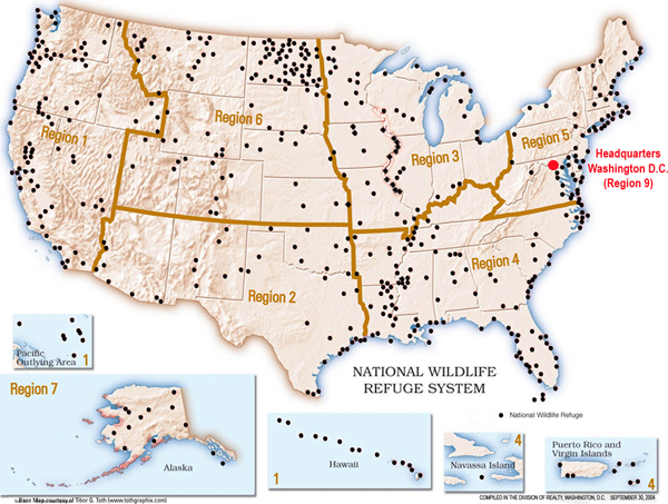
Figure 1. The Management Regions of the National Wildlife Refuge System.
The FWS maintains a website, Geographic Information Systems and Spatial Data (http://www.fws.gov/data/gishome.html) devoted specifically to sharing the spatial data that is being generated in support of its mission. Available on this site is an interactive map-server that allows the user to view many of the digital refuge boundaries and download the boundary data and the associated metadata. The website uses the ArcIMS internet map-server software, made by Environmental Science Research Institute (ESRI, Inc.). The digital boundaries are in the shapefile format with a standard attribute scheme that includes the name of, and contact information for, the particular refuge. Other available layers are the Wetland Management Districts, Interstate Highways, and major water bodies. The main site has spatial data for download from other federal agencies, State agencies, educational groups, non-government groups, as well as commercially sponsored sites. Also at the main site is information describing GIS tools, FWS data standards (such as vegetation), as well as links to several other unique GIS sites (such as the Environmental Conservation Online System) that provide viewing and downloading of spatial data.
Cartographers from the FWS have worked with the U.S. Geological Survey on a new map of the National Wildlife Refuge System, which was released in December 2002. The map is a combination of FWS and USGS data and will be included as part of the National Atlas (http://www.nationalatlas.gov/). This collaborative effort marks the first time a national map for the refuge system has been produced entirely in a digital format. The 1:7.5-million scale of the map is consistent for all areas of the U.S., with the exception of the Pacific Islands area, where a scale of 1:29 million was used to reflect an area extending from Hawaii to Guam. The consistent scale allows the viewer to appreciate Alaskas tremendous size and the true expanse of the wildlife refuges located there.
The boundaries of the National Wildlife Refuges are intended to protect specific wildlife habitats and natural resources, as identified by FWS biologists. Private lands within these boundaries are purchased only from willing sellers. Maps that reflect these land ownership patterns have used a consistent format since 1936. In May 2002, cartographers from all seven management regions gathered to update the existing Mapping chapter in the FWS manual, which describes Service-wide standards for mapping (http://www.fws.gov/policy/343fw3.html). A new cartographic format for all maps produced for the FWS was designed and has been implemented since that time. The new mapping standards are based on existing graphic standards for FWS publications, which is similar to the standards for the other agencuies within the Department of the Interior. The maps will use USGS digital orthophoto quads and digital raster graphs as a base, with color shading to represent the various land status categories (see Figures 2 and 3).
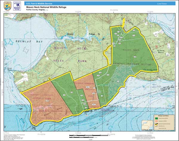
Figure 2. Example of the new map format, based on the existing FWS graphic standards.
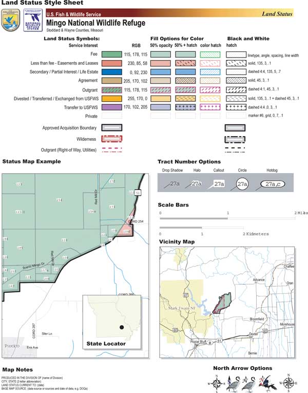
Figure 3. Guidance for making land status maps for the FWS are shown on the "style sheet."
In October 2004, the same group of cartographers gathered to revise the Standard Operating Procedure for generating digital refuge boundaries and digital land status. The new SOP document will implement the use of the ArcGIS "geodatabase" format to store boundaries, FWS-owned parcels, and private lands and their associated attributes (see Figure 4).
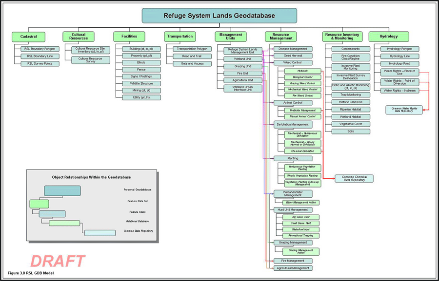
Figure 4. Proposed design of the geodatabase for lands within the National Wildlife Refuge System.
A GIS coordination team at FWS Headquarters in Washington, D.C., has recently completed (1/06/2006) an extensive report to the FWS Directorate entitled "Recommendations for GIS in the National Wildlife Refuge System." The report contains recommendations on national, regional, and field office needs for spatial data acquisition, development, and management in support of the National Wildlife Refuge System programs. This will help identify programs with common data needs, provide access to data systems and existing databases, reduce duplication of efforts, and provide technical support for science-based decision-making. The report will soon be available at the main FWS GIS website (http://www.fws.gov/data/gishome.html). The major recommendations are as follows:

![]() U.S. Department of the Interior |
U.S. Geological Survey
U.S. Department of the Interior |
U.S. Geological Survey
URL: pubsdata.usgs.gov /pubs/of/2005/1428/vandegraft/index.html
Page Contact Information: David R. Soller
Page Last Modified: Saturday, 12-Jan-2013 22:05:25 EST
