Open-File Report 2006–1052
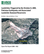 
The October 8, 2005, Kashmir earthquake (M 7.6) triggered several thousand landslides, mainly rock falls and rock slides, in the epicentral area near the cities of Muzafarrabad and Balakot, Pakistan. Most of these were shallow, coalescing rock slides emanating from highly sheared and deformed limestone and dolomite of the Precambrian Muzafarrabad Formation. The largest landslide triggered by the earthquake is located approximately 32 kilometers southeast of Muzafarrabad in a tributary valley of the Jhelum River. This landslide is a debris avalanche of approximately 80 million cubic meters volume within the Miocene Murree Formation consisting of mixed sandstone, mudstone, shale, and limestone. The avalanche buried the village of Dandbeh and resulted in approximately...>>MORE |
Version 1.0 Posted May 2006
|
Part or all of this report is presented in Portable Document Format (PDF); the latest version of Adobe Acrobat Reader or similar software is required to view it. Download the latest version of Acrobat Reader, free of charge or go to access.adobe.com for free tools that allow visually impaired users to read PDF files.
