|
|
|
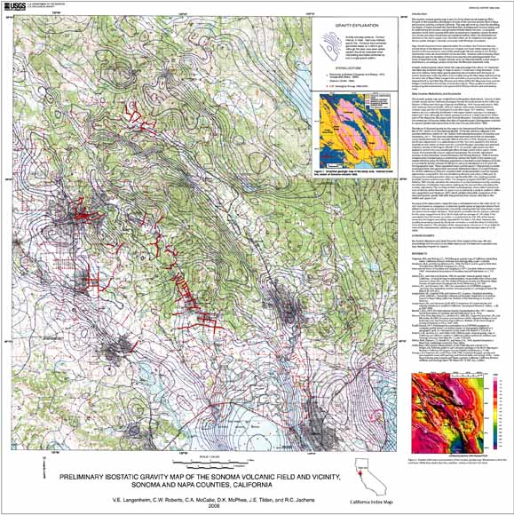
This isostatic residual gravity map is part of a three-dimensional mapping effort focused on the subsurface distribution of rocks of the Sonoma volcanic field in Napa and Sonoma counties, northern California. This map will serve as a basis for modeling the shapes of basins beneath the Santa Rosa Plain and Napa and Sonoma Valleys, and for determining the location and geometry of faults within the area. Local spatial variations in the Earth's gravity field (after accounting for variations caused by elevation, terrain, and deep crustal structure explained below) reflect the distribution of densities in the mid to upper crust. Densities often can be related to rock type, and abrupt spatial changes in density commonly mark lithologic boundaries. High-density basement rocks exposed within the northern San Francisco Bay area include those of the Mesozoic Franciscan Complex and Great Valley Sequence present in the mountainous areas of the quadrangle. Alluvial sediment and Tertiary sedimentary rocks are characterized by low densities. However, with increasing depth of burial and age, the densities of these rocks may become indistinguishable from those of basement rocks. Tertiary volcanic rocks are characterized by a wide range in densities, but, on average, are less dense than the Mesozoic basement rocks. Isostatic residual gravity values within the map area range from about -41 mGal over San Pablo Bay to about 11 mGal near Greeg Mountain 10 km east of St. Helena. Steep linear gravity gradients are coincident with the traces of several Quaternary strike-slip faults, most notably along the West Napa fault bounding the west side of Napa Valley, the projection of the Hayward fault in San Pablo Bay, the Maacama Fault, and the Rodgers Creek fault in the vicinity of Santa Rosa. These gradients result from juxtaposing dense basement rocks against thick Tertiary volcanic and sedimentary rocks. |
Download this map as a 35" x 35" PDF document (of2006-1056.pdf; 22.4 MB)
download the gravity data as an Excel .xls spreadsheet (of2006-1056_gravity.xls; 540 KB)
For questions about the content of this report, contact Vicki Langenheim.
Learn more about Understanding Geohydrology; Investigating Geohydrologic Systems from Geologic Framework and History
| Help
| PDF help
| Publications main page | Open-File
Reports for 2006 |