Open-File Report 2006-1059
![]() Title | Geologic Setting | Introduction
| Methods | Bathymetric Overview |
Interpretation | Data Catalog
| Acknowledgments | References
| Figures
| Contacts
Title | Geologic Setting | Introduction
| Methods | Bathymetric Overview |
Interpretation | Data Catalog
| Acknowledgments | References
| Figures
| Contacts
 |
||
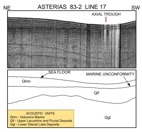
Figure 5. Subbottom profile from line 17 in southeastern Long Island Sound collected during RV ASTERIAS cruise 83-2 (Needell and others, 1987; Poppe and others, 2002a). Location of profile is shown in figure 8. Profile and interpretation show the thinning of the Holocene marine unit in the axial trough, relatively smooth nature of the sea floor, and acoustic character of the underlying units. | ||

![]() U.S. Department of the Interior |
U.S. Geological Survey
U.S. Department of the Interior |
U.S. Geological Survey
URL: http://pubsdata.usgs.gov/pubs/of/2006/1059/html/fig5.html
Page Contact Information: GS Pubs Web Contact
Page Last Modified: Tuesday, 16-Sep-2025 16:01:17 EDT
