|
|
|
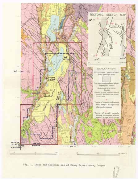
The U.S. Geological Survey (USGS) conducted geophysical studies in support of the resource appraisal of the Crump Geyser Known Geothermal Resource Area (KGRA). This area was designated as a KGRA by the USGS, and this designation became effective on December 24, 1970. The land classification standards for a KGRA were established by the Geothermal Steam Act of 1970 (Public Law 91-581). Federal lands so classified required competitive leasing for the development of geothermal resources. The author presented an administrative report of USGS geophysical studies entitled "Geophysical background of the Crump Geyser area, Oregon, KGRA" to a USGS resource committee on June 17, 1975. This report, which essentially was a description of geophysical data and a preliminary interpretation without discussion of resource appraisal, is in Appendix 1. Reduction of sheets or plates in the original administrative report to page-size figures, which are listed and appended to the back of the text in Appendix 1, did not seem to significantly degrade legibility. Bold print in the text indicates where minor changes were made. A colored page-size index and tectonic map, which also show regional geology not shown in figure 2, was substituted for original figure 1. Detailed descriptions for the geologic units referenced in the text and shown on figures 1 and 2 were separately defined by Walker and Repenning (1965) and presumably were discussed in other reports to the committee. Heavy dashed lines on figures 1 and 2 indicate the approximate KGRA boundary. One of the principal results of the geophysical studies was to obtain a gravity map (Appendix 1, fig. 10; Plouff, and Conradi, 1975, pl. 9), which reflects the fault-bounded steepness of the west edge of sediments and locates the maximum thickness of valley sediments at about 10 kilometers south of Crump Geyser. Based on the indicated regional-gravity profile and density-contrast assumptions for the two-dimensional profile, the maximum sediment thickness was estimated at 820 meters. A three-dimensional gravity model would have yielded a greater thickness. Audiomagnotelluric measurements were not made as far south as the location of the gravity low, as determined in the field, due to a lack of communication at that time. A boat was borrowed to collect gravity measurements along the edge of Crump Lake, but the attempt was curtailed by harsh, snowy weather on May 21, 1975, which shortly followed days of hot temperature. Most of the geophysical data and illustrations in Appendix 1 have been published (Gregory and Martinez, 1975; Plouff, 1975; and Plouff and Conradi, 1975), and Donald Plouff (1986) discussed a gravity interpretation of Warner Valley at the Fall 1986 American Geophysical Union meeting in San Francisco. Further interpretation of possible subsurface geologic sources of geophysical anomalies was not discussed in Appendix 1. For example, how were apparent resistivity lows (Appendix 1, figs. 3-6) centered near Crump Geyser affected by a well and other manmade electrically conductive or magnetic objects? What is the geologic significance of the 15-milligal eastward decrease across Warner Valley? The explanation that the two-dimensional gravity model (Appendix 1, fig. 14) was based on an inverse iterative method suggested by Bott (1960) was not included. Inasmuch as there was no local subsurface rock density distribution information to further constrain the gravity model, the three-dimensional methodology suggested by Plouff (1976) was not attempted. Inasmuch as the associated publication by Plouff (1975), which released the gravity data, is difficult to obtain and not in digital format, that report is reproduced in Appendix 2. Two figures of the publication are appended to the back of the text. A later formula for the theoretical value of gravity for the given latitudes at sea level (International Association of Geodesy, 1971) should be used to re-compute gravity anomalies. To merge the observed-gravity values printed in that report with later measurements, an empirically determined constant gravity datum shift should be applied. |
Download the text of this publication as a 51-page PDF file (of2006-1110.pdf; 37.3 M).
GIS data (shapefile made from table 1; tab-delimited text included): 2006-1110.zip (24 kB)
Metadata (text file)
For questions about the content of this report, contact Don Plouff
| Help
| PDF help
| Publications main page
| Open-File Reports for 2006
|
This report is available only on the web.