etopo2_8bit.sid: Global bathymetry image (MrSid format)

Metadata also available as

Frequently-anticipated questions:


What does this data set describe?

Title: etopo2_8bit.sid: Global bathymetry image (MrSid format)
Abstract:
The National Geophysical Data Center assembled a 2-minute gridded database of global relief data, referred to as ETOPO2. The seafloor data between latitudes 64° North and 72° South are from the work of Smith and Sandwell (1997). These data were derived from satellite altimetry observations combined with carefully, quality-assured shipboard echo-sounding measurements, by Dr. Walter H.F. Smith, of the NOAA Laboratory for Satellite Altimetry and Dr. David T. Sandwell, of the Institute of Geophysics and Planetary Physics at the University of California, San Diego. This dataset formed the basis for the creating of the bathymetry image for this product's GIS.
  1. How should this data set be cited?

    Buczkowski, Brian J. , 2006, etopo2_8bit.sid: Global bathymetry image (MrSid format):,.

    Online Links:

    This is part of the following larger work.

    Buczkowski, Brian J. , and Kelsey, Sarah A. , 2006, Archival Policies and Collections Database for the Woods Hole Science Center's Marine Sediment Samples: Open-File Report 2006-1187, U.S. Geological Survey, Coastal and Marine Geology Program, Woods Hole Science Center, Woods Hole, MA.

    Online Links:

  2. What geographic area does the data set cover?

    West_Bounding_Coordinate: -180.000000
    East_Bounding_Coordinate: 180.000000
    North_Bounding_Coordinate: 90.000000
    South_Bounding_Coordinate: -90.000000

  3. What does it look like?

    <http://pubs.usgs.gov/of/2006/1187/basemaps/etopo2/etopo2_8bit.jpg> (JPEG)
    Image showing extent of data layer coverage

  4. Does the data set describe conditions during a particular time period?

    Calendar_Date: 2001
    Currentness_Reference: publication date

  5. What is the general form of this data set?

    Geospatial_Data_Presentation_Form: remote-sensing image

  6. How does the data set represent geographic features?

    1. How are geographic features stored in the data set?

      This is a Raster data set. It contains the following raster data types:

      • Dimensions 8401 x 24001 x 1, type Pixel

    2. What coordinate system is used to represent geographic features?

      Horizontal positions are specified in geographic coordinates, that is, latitude and longitude. Latitude and longitude values are specified in Decimal degrees.

      The horizontal datum used is World Geodetic System 1984.

  7. How does the data set describe geographic features?

    Band_1

    ObjectID
    Internal feature number. (Source: ESRI)

    Sequential unique whole numbers that are automatically generated.

    Value

    Count

    Band_2

    ObjectID
    Internal feature number. (Source: ESRI)

    Sequential unique whole numbers that are automatically generated.

    Value

    Count

    Band_3

    ObjectID
    Internal feature number. (Source: ESRI)

    Sequential unique whole numbers that are automatically generated.

    Value

    Count


Who produced the data set?

  1. Who are the originators of the data set? (may include formal authors, digital compilers, and editors)

  2. Who also contributed to the data set?

  3. To whom should users address questions about the data?

    Brian J. Buczkowski
    U.S. Geological Survey
    Core Curator and Data Management Specialist
    384 Woods Hole Road
    Woods Hole, MA 02543-1598
    USA

    508-458-8700 x2361 (voice)
    508-457-2310 (FAX)
    bbuczkowski@usgs.gov


Why was the data set created?

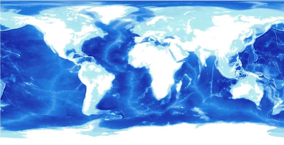
This image provides a color view of the etopo2 bathymetry for the project area and is used as a basemap for overlaying sample data.


How was the data set created?

  1. From what previous works were the data drawn?

    NGDC ETOPO2 (source 1 of 1)
    National Oceanic and Atmospheri, National Geophysical Data Center (NGDC), 2001, 2-minute Gridded Global Relief Data (ETOPO2).

    Online Links:

    Type_of_Source_Media: CD-ROM

  2. How were the data generated, processed, and modified?

    (process 1 of 4)
    The desired data was extracted from the ETOPO2 global relief data in the ESRI ASCII format. The ASCII dataset was then converted to an ESRI grid file and combined to a single ESRI grid file.

    Person who carried out this activity:

    Brian J. Buczkowski
    U.S. Geological Survey
    Core Curator and Data Management Specialist
    384 Woods Hole Road
    Woods Hole, MA 02543-1598
    USA

    508-458-8700 x2361 (voice)
    508-457-2310 (FAX)
    bbuczkowski@usgs.gov

    Data sources produced in this process:
    • etopo2

    (process 2 of 4)
    The grid was converted to a tiff image using the extension image_convert_georef.avx downloaded from www.esri.com.

    Data sources used in this process:

    • etopo2

    Data sources produced in this process:

    • etopo2.tif
    • etopo2.tfw

    (process 3 of 4)
    The tiff image was converted to 8 bit using Photoshop CS in order to reduce the file size.

    Data sources used in this process:

    • etopo2.tif
    • etopo2.tfw

    Data sources produced in this process:

    • etopo2_8bit.tif
    • etopo2_8bit.tfw

    (process 4 of 4)
    The tiff image was compressed using Lizardtech's Mr. Sid compression software.

    Data sources used in this process:

    • etopo2_8bit.tif
    • etopo2_8bit.tfw

    Data sources produced in this process:

    • etopo2_8bit.sid
    • etopo2_8bit.sdw

  3. What similar or related data should the user be aware of?


How reliable are the data; what problems remain in the data set?

  1. How well have the observations been checked?

  2. How accurate are the geographic locations?

  3. How accurate are the heights or depths?

  4. Where are the gaps in the data? What is missing?

  5. How consistent are the relationships among the observations, including topology?


How can someone get a copy of the data set?

Are there legal restrictions on access or use of the data?

Access_Constraints: None.
Use_Constraints:
Bathymetry is not to be used for navigation purposes. Public domain data from the U.S. Government are freely redistributable with proper metadata and source attribution. Please recognize the U.S. Geological Survey (USGS) as the source of this information.

  1. Who distributes the data set?[Distributor contact information not provided.]

  2. What's the catalog number I need to order this data set?

    Downloadable Data; etopo2_8bit.sid

  3. What legal disclaimers am I supposed to read?

    Although this data set has been used by the U.S. Geological Survey (USGS), no warranty, expressed or implied, is made by the USGS as to the accuracy of the data and/or related materials. The act of distribution shall not constitute any such warranty, and no responsibility is assumed by the USGS in the use of these data or related materials.

    Trade, firm, or product names and other references to non-USGS products and services are provided for information only and do not constitute endorsement or warranty, express or implied, by the USGS, USDOI, or U.S. Government, as to their suitability, content, usefulness, functioning, completeness, or accuracy.

  4. How can I download or order the data?

  5. What hardware or software do I need in order to use the data set?

    This image is available as a MrSID image with an accompanying world file. To utilize this data, the user must have an image viewer, image processing or GIS software package capable of importing a MrSID image.


Who wrote the metadata?

Dates:
Last modified: 19-Jul-2006
Metadata author:
Brian J. Buczkowski
U.S. Geological Survey
Core Curator and Data Management Specialist
384 Woods Hole Road
Woods Hole, MA 02543-1598
USA

508-458-8700 x2361 (voice)
508-457-2310 (FAX)
bbuczkowski@usgs.gov

Metadata standard:
FGDC Content Standards for Digital Geospatial Metadata (FGDC-STD-001-1998)
Metadata extensions used:


Generated by mp version 2.8.6 on Tue Oct 03 09:23:27 2006