 |
|
|
||||
| USGS, FEMA, NOAA |
|
|
|
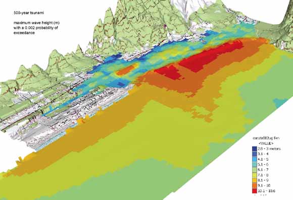
Abstract FEMA Flood Insurance Rate Map (FIRM) guidelines do not currently exist for conducting and incorporating tsunami hazard assessments that reflect the substantial advances in tsunami research achieved in the last two decades; this conclusion is the result of two FEMA-sponsored workshops and the associated Tsunami Focused Study. Therefore, as part of FEMA’s Map Modernization Program, a Tsunami Pilot Study was carried out in the Seaside/Gearhart, Oregon, area to develop an improved Probabilistic Tsunami Hazard Assessment (PTHA) methodology and to provide recommendations for improved tsunami hazard assessment guidelines. The Seaside area was chosen because it is typical of many coastal communities in the section of the Pacific Coast from Cape Mendocino to the Strait of Juan de Fuca, and because State Agencies and local stakeholders expressed considerable interest in mapping the tsunami threat to this area. The study was an interagency effort by FEMA, U.S. Geological Survey and the National Oceanic and Atmospheric Administration, in collaboration with the University of Southern California, Middle East Technical University. Portland State University, Horning Geosciences, Northwest Hydraulics Consultants, and the Oregon Department of Geological and Mineral Industries. Draft copies and a briefing on the contents, results and recommendations of this document were provided to FEMA officials before final publication. |
| Frank | González | NOAA/PMEL |
| Eric | Geist | U.S. Geological Survey |
| Costas | Synolakis | Univ. of Southern California |
| Diego | Arcas | NOAA/PMEL |
| Doug | Bellomo | FEMA, Dept. of Homeland Security |
| David | Carlton | FEMA, Dept. of Homeland Security |
| Tom | Horning | Horning Geoscience |
| Bruce | Jaffe | U.S. Geological Survey |
| Jeff | Johnson | Northwest Hydraulics Consultants |
| Utku | Kanoglu | Middle East Technical University, Ankara, Turkey |
| Hal | Mofjeld | NOAA/PMEL |
| Jean | Newman | NOAA/PMEL |
| Tom | Parsons | U.S. Geological Survey |
| Robert | Peters | U.S. Geological Survey |
| Curt | Peterson | Portland State University |
| George | Priest | Oregon Dept. of Geology & Minerals |
| Vasily | Titov | NOAA/PMEL |
| Angie | Venturato | NOAA/PMEL |
| Joe | Weber | FEMA, Dept. of Homeland Security |
| Florence | Wong | U.S. Geological Survey |
| Ahmet | Yalciner | Middle East Technical University, Ankara, Turkey |
Download Open-File Report 2006-1234 as a 161-page PDF file (61.6 MB)
Download Plate 1 as a 58"x28" PDF file (2.8 MB)
see also: USGS Data Series 236: Seaside, Oregon, Tsunami Pilot Study - Modernization of FEMA Flood Hazard Maps: GIS Data [http://pubs.usgs.gov/ds/2006/236/]
For questions about the content of this report, contact Eric Geist
Download a current version of Adobe Reader for free
| Help
| PDF help
| Western reports main page | Open-File Reports for 2006 |
| Privacy
Statement | Disclaimer
| Accessibility |
| Geologic
Division | Western Coastal and Marine Geology
|